
Dangerous heat wave to spread across the Western and Central US, maximum temperatures up to 43°C (110°F)
The first widespread and significant heat wave of the summer is forecast to develop across the Intermountain West and Plains beginning Friday, July 10, 2026. Widespread temperatures above 38°C (100°F) are forecast, with isolated highs of up to 43°C (110°F). The Weather Prediction Center (WPC) forecasts widespread Major (Level 3) to locally Extreme (Level 4) HeatRisk between Friday and Wednesday, July 10 and 15.
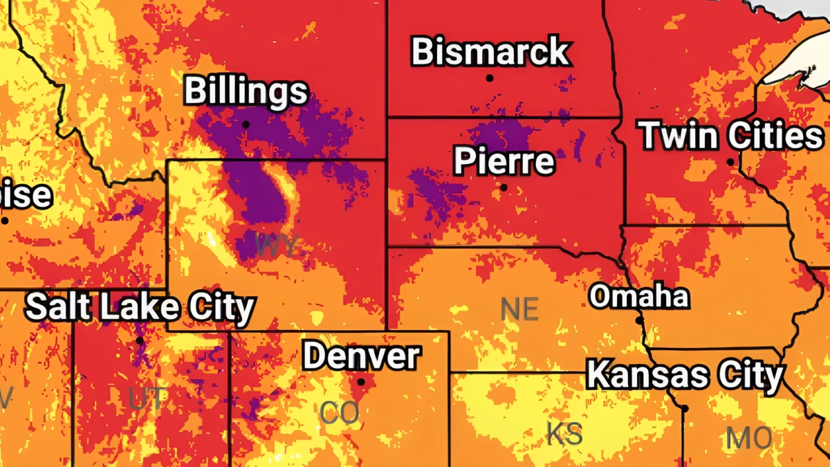
Image credit: NWS/WPC
A dangerous heat wave is forecast to expand from the Intermountain West into the Plains through next week, bringing widespread temperatures above 38°C (100°F) and localized highs up to 43°C (110°F) possible. Widespread major to locally extreme heat stress is forecast across the region.
The first widespread and significant heat wave of the summer is expected to develop on Friday, July 10, across the Intermountain West and Plains before expanding early next week.
Forecast high temperatures of 35–41°C (95–105°F) are expected across a broad swath of the region, with isolated locations potentially surpassing 43°C (110°F) by Sunday. Forecasters said the event could produce numerous daily high-temperature records, along with several monthly and even all-time records.

The combination of extremely hot daytime temperatures and potentially record-warm overnight lows is forecast to generate widespread Major (Level 3) to locally Extreme (Level 4) HeatRisk, significantly increasing accumulated heat stress.
“This heatwave will quickly become dangerous to anyone without adequate cooling or hydration,” the WPC said.
Widespread Major HeatRisk is forecast from the Great Basin and Intermountain West across much of the northern Plains between July 10 and July 15, with pockets of Extreme HeatRisk forecast over parts of Montana and Wyoming.
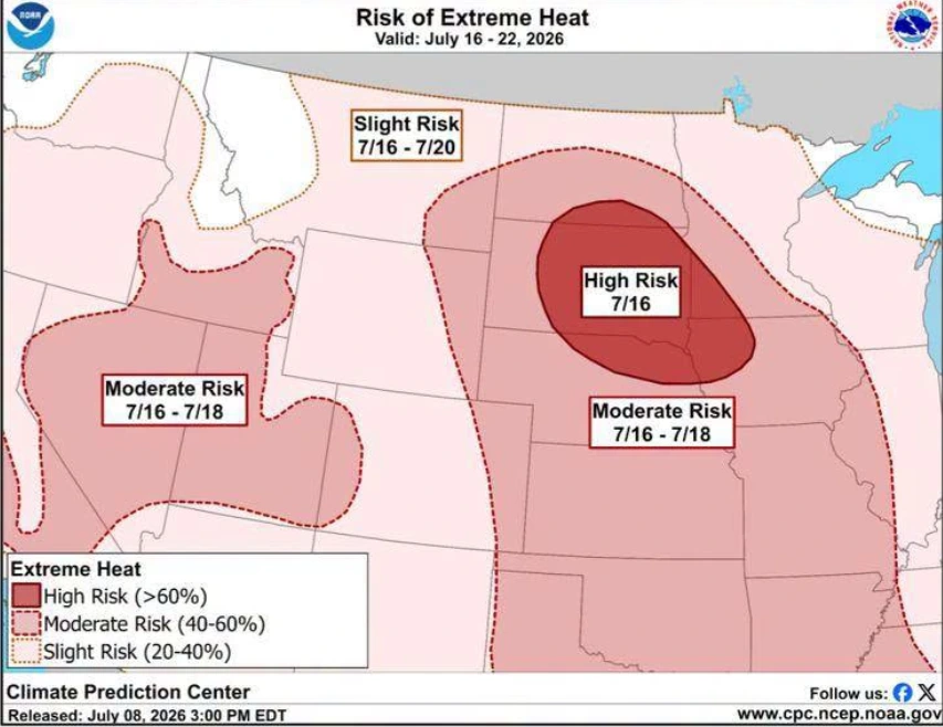
There is a High Risk (over 60% probability) of extreme heat across portions of the northern Plains and Upper Mississippi Valley around July 16. A Moderate Risk (40–60%) probability extends into surrounding areas of the Great Plains through July 18, while a broader 20-40% probability covers parts of the Great Basin and adjacent western states.
Heat indices of over 38°C (100°F) will be possible across many high- and moderate-risk areas, with portions of the central and southern Plains expected to experience heat index values above 41°C (105°F).
The prolonged heat may be especially hazardous because many parts of the Plains experienced near- to below-normal temperatures during June. This means the residents are yet to be fully acclimatized to the heat.
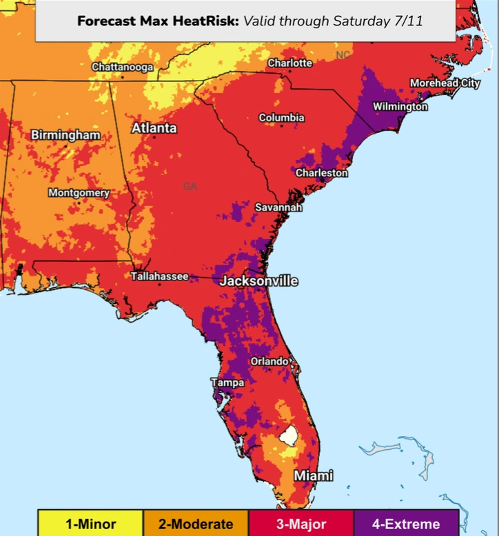
Meanwhile, hazardous heat continues across portions of the Southeast through Saturday, July 11, under a persistent subtropical ridge.
Across parts of Georgia, the Carolinas, and Florida, afternoon temperatures in the low 32s to upper 30s°C (low 90s to low 100s°F) combined with high humidity are expected to produce heat index values of 40–43°C (105–110°F). Overnight lows will remain unusually warm, generally in the mid-20s to upper 20s°C (mid-to upper 70s°F) and around 27°C (80°F), providing little nighttime relief.
A gradual moderation in temperatures is expected across the eastern United States this weekend as a backdoor cold front pushes southward from New England. Increased cloud cover and rainfall from the central Plains into the Mid-Atlantic will also help suppress daytime temperatures, allowing highs to return closer to seasonal averages across the Mississippi and Ohio valleys before cooler air reaches the Southeast.
The WPC advises residents in affected areas to limit strenuous outdoor activity during the hottest part of the day, stay hydrated, seek air-conditioned spaces or cooling centers whenever possible, and regularly check on vulnerable family members and neighbors. Officials also warn against leaving children or pets unattended in vehicles and recommend ensuring outdoor animals have access to shade and fresh water.
References:
1 Short Range Forecast Discussion – NWS/WPC – July 10, 2026

I am an Assistant Editor and Severe Weather & Science Journalist at The Watchers, specializing in real-time severe weather coverage, geophysical event reporting, and research-driven scientific analysis. You can reach me at rishav(at)watchers(.)news.

Commenting rules and guidelines
We value the thoughts and opinions of our readers and welcome healthy discussions on our website. In order to maintain a respectful and positive community, we ask that all commenters follow these rules.