
NHC designates 100% chance of cyclone formation for EP96
The National Hurricane Center (NHC) assigned a 100% probability of tropical cyclone formation within the next seven days to disturbance EP96 at 05:00 PDT (12:00 UTC) on July 14, 2026, while raising the 48-hour probability to 90%. If it does form it will be the fifth named storm of the season. A low-pressure circulation with an estimated minimum central pressure of 1 007 hPa had already developed by 08:00 PDT (15:00 UTC), and a tropical depression or tropical storm is expected to form later on July 14 as the system moves west-northwest offshore of southwestern Mexico.
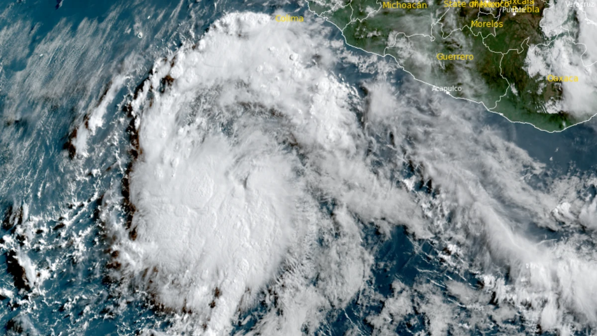
Satellite image of EP96 at 16:00 UTC on July 14, 2026. Credit: NOAA/GOES-19, RAMMB/CIRA, The Watchers
The National Hurricane Center (NHC) designated a 100% chance of cyclone formation for an area of disturbance designated EP96.
The designation was given in an update published at 05:00 PDT (12:00 UTC) on July 14, with the NHC assigning a 90% chance of cyclone formation within the next 48 hours, and a 100% chance of cyclone formation in the next seven days.
If it does develop into a tropical storm, it will be named Elida and become the fifth named storm of the season. The disturbance is located offshore of Southwestern Mexico. Showers and thunderstorms had become better organized and were producing gusty winds associated with a tropical wave located south-southwest of the coast of southwestern Mexico.
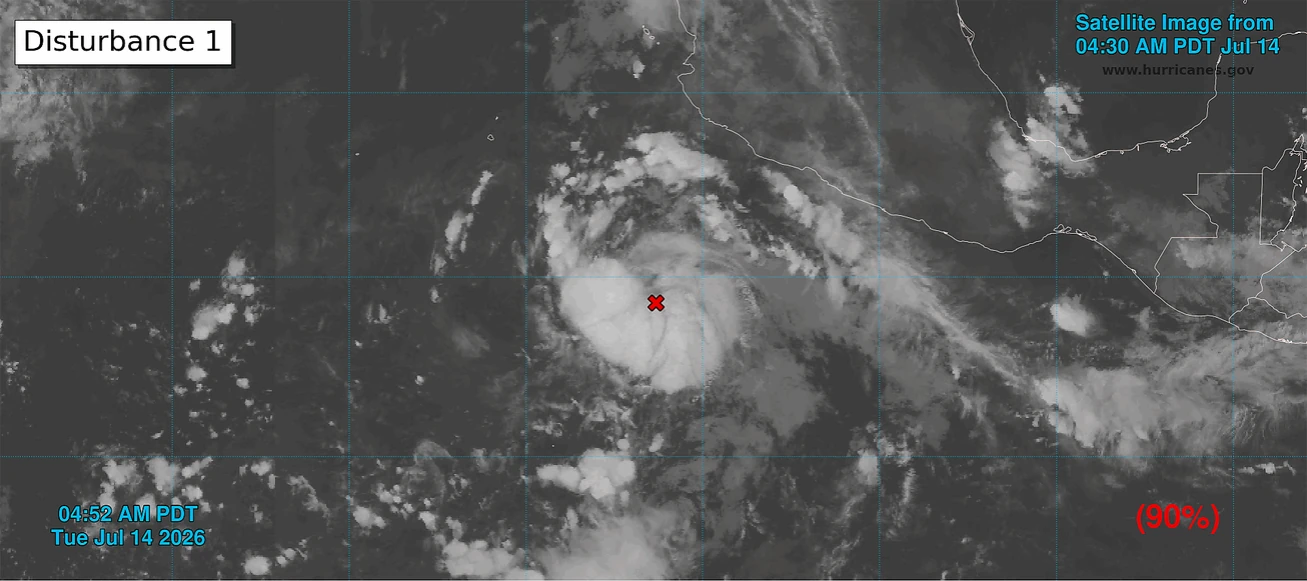
A low pressure circulation with an estimated minimum central pressure of 1 007 hPa had already developed in the region based on satellite imagery at 08:00 PDT (15:00 UTC).
A tropical depression or a tropical storm could form on July 14, while the system will continue moving west-northwest, the NHC reported. The system is expected to stay offshore of the coast of Mexico.
Right Next to EP96 is another disturbance with a 70% chance of cyclone formation in the next seven days. A tropical depression is likely to form in this area by the weekend, according to the NHC.
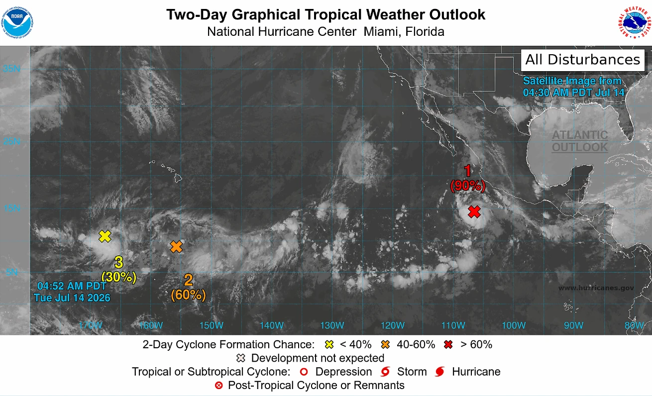
Further west, two areas of disturbance located south of Hawaii have a medium chance of cyclone formation during this week.
The first area of disturbance, designated CP90, has a 50% chance of cyclone formation over the next seven days and a 30% chance in the next 48 hours. The area is located southwest of the Hawaiian islands, and is producing disorganized showers and thunderstorms.
Conditions seem favorable for a tropical depression to develop later in the week. If that happens, the system is forecast to continue moving northwest and will remain far offshore southwest of the Hawaiian islands, according to the NHC.
Meanwhile, disturbance CP91 has 60% chance of becoming a cyclone for both the 48-hour and seven-day periods. It is expected to move into an unfavorable environment by the end of the week without developing further.
References:
1 Tropical Weather Outlook – NOAA/NHC – July 14, 2026
2 Tropical Weather Discussion – NOAA/NHC – July 14, 2026

I am an Assistant Editor and Severe Weather & Science Journalist at The Watchers, specializing in real-time severe weather coverage, geophysical event reporting, and research-driven scientific analysis. You can reach me at rishav(at)watchers(.)news.

Commenting rules and guidelines
We value the thoughts and opinions of our readers and welcome healthy discussions on our website. In order to maintain a respectful and positive community, we ask that all commenters follow these rules.