
NHC warns of life-threatening flash flooding in southern Mexico and Central America
The National Hurricane Center (NHC) is monitoring two eastern Pacific systems, EP91 south of Acapulco, Mexico and EP92 offshore Central America. The center warns life-threatening flash flooding is possible across southern Mexico, Costa Rica, Nicaragua, El Salvador and Guatemala through early this week.
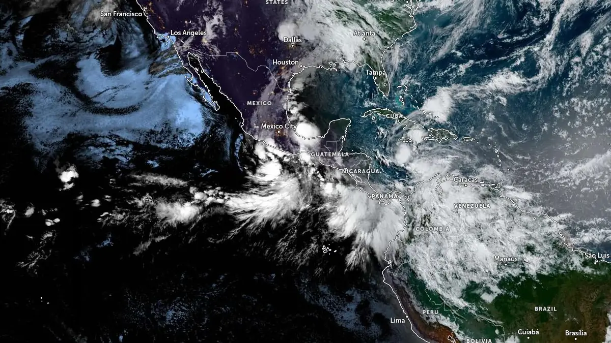
Satellite image acquired at 12:10 UTC on June 7, 2026. Credit: NOAA/GOES-East, Zoom Earth, The Watchers
According to the NHC Tropical Weather Outlook issued at 12:00 UTC on Sunday, June 7, EP91 was located a couple of hundred km south of Acapulco and had a 90% chance of tropical cyclone formation within 48 hours and 90% within seven days. The disturbance was producing a broad area of showers and thunderstorms, was gradually becoming better organized, and was forecast to move northeastward and then northward toward the coast of southern Mexico tonight and Monday.
NHC said a tropical depression will likely form from EP91 later today. Regardless of development, however, heavy rainfall and life-threatening flash flooding are possible across portions of southern Mexico through early this week.
Shower and thunderstorm activity associated with the broad low-pressure area EP92, located offshore Central America, had changed little in organization during the morning, but some development was still expected.
This second system had a 70% chance of tropical cyclone formation within 48 hours and 70% within seven days, with a tropical depression likely during the next day or two as it moves slowly northward toward the coast of Central America.
Interests along the Pacific coasts of northwestern Costa Rica, Nicaragua, Honduras, and El Salvador were advised to monitor EP92. NHC said heavy rainfall and life-threatening flash flooding are possible across portions of Costa Rica, Nicaragua, El Salvador, and Guatemala through early this week, regardless of whether the system becomes a tropical depression.
The Tropical Weather Discussion issued by NHC at 10:05 UTC on June 7 placed both systems along the monsoon trough. EP91 was described as a broad low-pressure area a few hundred km southwest of Zihuatanejo, Mexico, with numerous heavy showers and isolated thunderstorms expected to persist through the day. Fresh to strong monsoonal southwest to west winds and seas of 1.8–3 m (6–10 feet) in large southwest swell were reported offshore southern Mexico.
Farther southeast, NHC reported a developing low-pressure area along 90°W offshore Central America, with scattered heavy showers and isolated thunderstorms. The agency forecast a new set of large southwest swells across Central America offshore waters from Sunday through early Tuesday, with moderate seas becoming rough by Sunday evening and very rough by Monday morning.
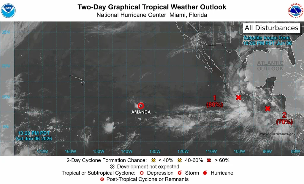
On Saturday, June 6, the Ministry of Environment and Natural Resources (MARN) of El Salvador reported a low-pressure area in the Intertropical Convergence Zone off the Salvadoran Pacific coast had a 70% chance of evolving into a tropical cyclone within 48 hours and seven days. MARN said the system would continue moving slowly near Central America, increasing Pacific moisture inflow and producing temporal-type rains over El Salvador, mainly along the coastal zone, volcanic chain, and mountainous sectors.
MARN forecast the heaviest Salvadoran rainfall focus on June 7 along the coastal strip and mountain areas, followed by rainfall between June 8 and 11 in municipalities near the volcanic chain and coast. The agency also forecast winds of 10–30 km/h (6–19 mph), with occasional gusts of 50 km/h (31 mph) in coastal areas on Sunday and in coastal and high-elevation areas on Monday.
El Salvador’s General Directorate of Civil Protection (DGPC) instructed departmental, municipal, and communal civil protection commissions to strengthen territorial monitoring, follow risk conditions, check communication and alert systems, and monitor areas with histories of flooding, landslides, falling trees, and sudden river rises.
The National Institute of Seismology, Volcanology, Meteorology and Hydrology (INSIVUMEH) of Guatemala reported it expects rain across several regions during June 6 and 7, linked to atmospheric instability and a Pacific low near the coasts of Guatemala and El Salvador. Rainfall was expected from the south toward central Guatemala on Sunday, with additional activity over the Franja Transversal del Norte, eastern valleys, and parts of the Caribbean.
INSIVUMEH warned of possible sudden river rises, flooding, landslides, and lahars in the volcanic chain due to the forecast rainfall. Pacific-region temperatures were expected to remain high, with maximum values of 34–36°C (93–97°F), while Petén could see similar maximum temperatures.
References:
1 Tropical Weather Discussion – NWS/NHC – June 7, 2026
2 Tropical Weather Outlook – NWS/NHC – June 7, 2026
I'm a dedicated researcher, journalist, and editor at The Watchers. With over 20 years of experience in the media industry, I specialize in hard science news, focusing on extreme weather, seismic and volcanic activity, space weather, and astronomy, including near-Earth objects and planetary defense strategies. You can reach me at teo /at/ watchers.news.
Commenting rules and guidelines
We value the thoughts and opinions of our readers and welcome healthy discussions on our website. In order to maintain a respectful and positive community, we ask that all commenters follow these rules.