
Adelaide hit by 70% of its July rainfall in one day as successive cold fronts bring flooding and damaging winds to South Australia
Heavy rain from successive winter cold fronts flooded roads and properties across South Australia during July 2–3, 2026, prompting hundreds of State Emergency Service (SES) call-outs, disrupting transport, triggering a statewide Code Blue response for vulnerable people and delivering more than 100 mm (3.9 inches) of rain to parts of the Mount Lofty Ranges, according to the Bureau of Meteorology (BOM) and the SES.
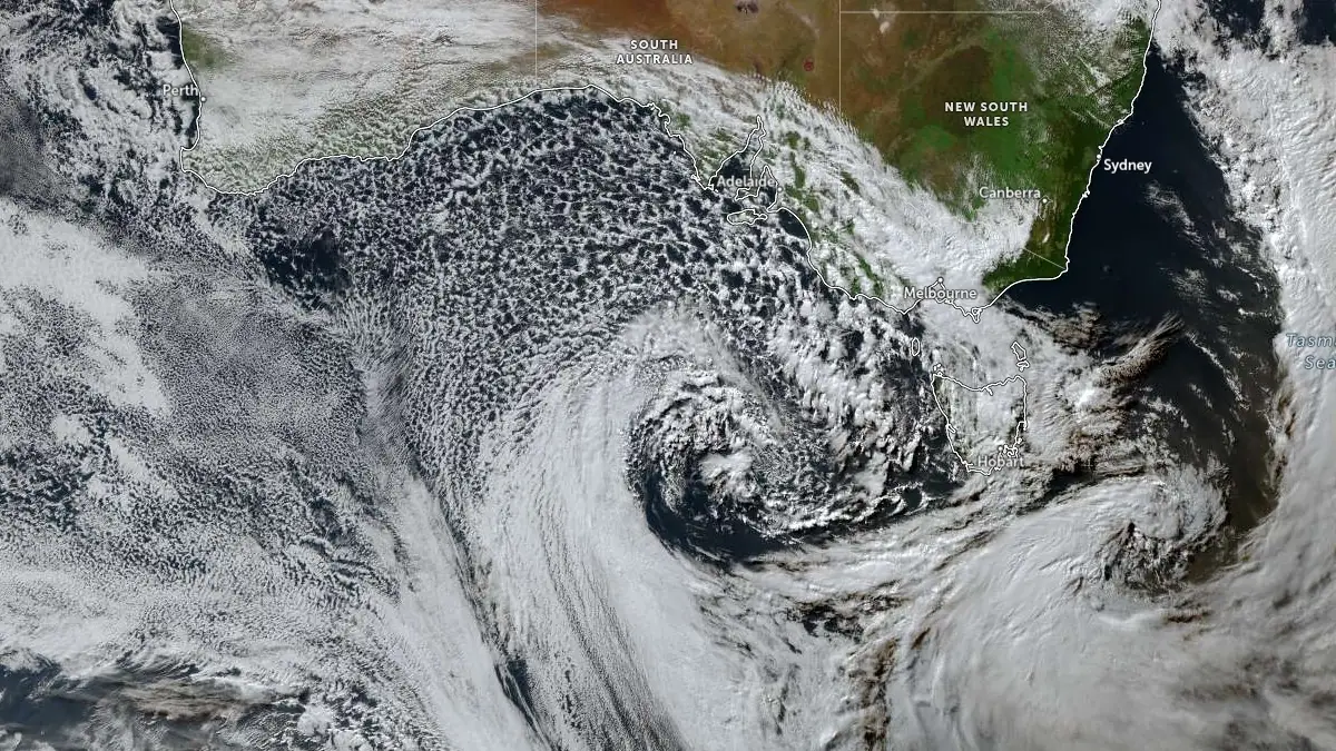
Satellite image acquired at 04:50 UTC on July 2, 2026. Credit: JMA/Himawari-9, Zoom Earth, The Watchers
Successive winter cold fronts swept across South Australia during July 2–3, bringing widespread rain, localized flooding, and damaging winds that affected Adelaide, the Adelaide Hills, and several regional districts. The Bureau of Meteorology (BOM) said metropolitan Adelaide received about 42 mm (1.7 inches) of rain in the 24 hours to Thursday morning, around 70% of Adelaide’s median July rainfall in a single day, while parts of the Mount Lofty Ranges recorded more than 100 mm (3.9 inches) over the event.
BOM’s weekly rainfall bulletin showed Lenswood received 117 mm (4.6 inches), Ashton 105 mm (4.1 inches), Uraidla 103 mm (4.1 inches), and both Mount Bold Reservoir and Woodhouse 101 mm (4.0 inches). Elsewhere, Adelaide (West Terrace/ngayirdapira) and Burnside each recorded 63 mm (2.5 inches), while Adelaide Airport measured 47 mm (1.9 inches). Significant rainfall also extended beyond the Adelaide region, with 48 mm (1.9 inches) at Stenhouse Bay and 44 mm (1.7 inches) at Port Vincent on Yorke Peninsula, while parts of Eyre Peninsula received about 30 mm (1.2 inches).
The South Australian State Emergency Service (SES) responded to more than 350 requests for assistance over approximately two days, including more than 160 incidents on July 2 alone. Most call-outs involved fallen trees, roof damage, water entering homes and businesses, and localized flooding. SES duty officer Kane Murray told ABC News there was still “a bit of a sting in the tail” as damaging winds shifted into the Lower South East following the heavy rain.
Floodwaters caused disruption across Adelaide and the Adelaide Hills. One southbound lane of James Congdon Drive at Mile End was closed after water overflowed near the SA Athletics Stadium. Cox Creek overflowed through Bridgewater, inundating facilities at the Bridgewater Raiders Football Club, while water ran high beside the Bridgewater Inn. Kingswood Oval was protected with tarpaulins after persistent rain, and the Piccadilly Cinema was again affected by water entering the historic building, according to Australian media reports.
Flood advice was also issued for the Patawalonga Lake system, where heavy inflows combined with high tides increased the risk of flooding in nearby residential areas. SES volunteers sandbagged properties at Glenelg North and advised residents to move belongings to higher ground before water levels gradually began to fall later in the day.
Emergency services again warned motorists not to drive through floodwaters after rescuing a 73-year-old driver whose vehicle became stranded in floodwater near Finniss after entering a closed road, according to media reports citing emergency authorities.
The severe weather prompted the South Australian Government to activate a statewide Code Blue response to provide additional support for people sleeping rough and other vulnerable residents during the cold and wet conditions. Human Services Minister Katrine Hildyard said the activation would expand outreach services, emergency accommodation, and welfare support while severe weather continued.
For many farmers, however, the rain brought welcome relief after prolonged dry conditions. Grain grower Tom Fielke, near Loxton, told ABC News that his property had received 228.5 mm (9 inches) of rain so far this year, describing the rainfall as a major improvement after several difficult seasons. SA Dairyfarmers’ Association president Rob Brokenshire said improved soil moisture and pasture growth would benefit producers but warned that prolonged wet weather could create a “wet drought,” where muddy conditions limit pasture production and increase feed costs.
Damaging wind warnings remained in place for parts of the Lower South East, where BOM forecast sustained winds of 50–65 km/h (31–40 mph) with gusts approaching 90 km/h (56 mph). While rainfall was expected to ease following the passage of the cold fronts, authorities warned that soaked ground, swollen creeks, and localized flooding could continue to affect parts of South Australia during the cleanup.
References:
1 Weekly Rainfall Bulletin (Rainfall for the 7 days to 9am Friday, July 3, 2026) – Bureau of Meteorology – July 3, 2026
2 Adelaide gets 70 per cent of July rain in one day as windy weather set to continue – ABC News Australia – July 2, 2026

I’m a science journalist and researcher at The Watchers, contributing to the Epicenter edition, where I cover peer-reviewed scientific research and emerging discoveries across Earth and space sciences. With a background in astronomy and a passion for environmental science, I’ve worked in shark and coral conservation in Fiji, conducting reef and shark-behavior research, contributing to mangrove restoration, and earning PADI Open Water and Coral Reef Certifications. I bring a blend of scientific rigor and storytelling to illuminate the discoveries shaping our planet and beyond.
Commenting rules and guidelines
We value the thoughts and opinions of our readers and welcome healthy discussions on our website. In order to maintain a respectful and positive community, we ask that all commenters follow these rules.