
Rare winter low threatens Western Australia with destructive winds and large waves
A Severe Weather Warning remains in effect across a large part of Western Australia as an unusually deep low-pressure system approaches the southwest coast, bringing the threat of damaging to destructive wind gusts, severe thunderstorms, heavy rainfall, isolated tornadoes, and very large waves through June 1, 2026.
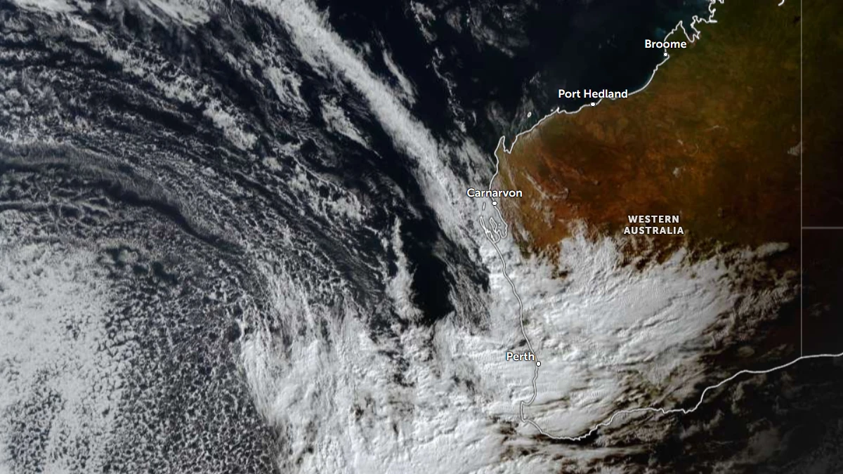
Satellite image of Western Australia 08:00 UTC on May 30, 2026. Credit: JMA/Himawari-9, Zoom Earth, The Watchers
A Severe Weather Warning remains in effect across a large part of Western Australia as an unusually deep low-pressure system approaches the southwest coast, bringing the threat of damaging to destructive wind gusts, severe thunderstorms, heavy rainfall, isolated tornadoes, and very large waves through June 1.
A warning area extends from approximately Kalbarri southward through the Lower West and South West districts and east toward the state’s southeast coast.
The Bureau of Meteorology (BoM) warns the system is capable of producing damaging to destructive wind gusts, heavy rainfall, severe thunderstorms, and dangerous coastal conditions during the period May 30 to June 1.
Showers and thunderstorms are forecast to move into the Central West during the evening of May 30, before spreading through the Lower West and South West overnight and into the morning of May 31.
The risk of damaging wind gusts and heavy rainfall is expected to expand eastward throughout May 31 as the system advances across the southern parts of the state.
Embedded thunderstorms are forecast to bring locally intense rainfall and severe wind gusts, while BoM also warns of an isolated tornado risk. Any tornadoes that develop are expected to be short-lived and fast-moving within the broader convective environment accompanying the frontal system.
The most dangerous phase of the event is forecast from the evening of May 31 into the morning of June 1. BoM identifies an area southwest of a line from approximately Lancelin to Albany as the region most exposed to locally destructive wind gusts, with the second surge of winds expected to deliver the highest potential for widespread severe weather impacts.
The event is being driven by a very deep low-pressure system approaching the Western Australian coast. Ahead of an advancing cold front, a trough is drawing moisture from the northwest into the southwestern districts.
As the front moves east on May 31, showers and thunderstorms are forecast to spread across the southern parts of the state. A secondary trough trailing the front is expected to generate a renewed burst of damaging to destructive winds late on May 31 and early on June 1.
Marine conditions are expected to deteriorate rapidly as the low approaches the coast. Offshore wave heights are forecast to reach up to 8 m (26 feet) on May 31, with large and powerful surf continuing into June 1 before extending farther east. BoM warns of dangerous surf, coastal erosion, and possible inundation of low-lying coastal areas exposed to the southwest swell.
Potential impacts include property damage, fallen trees, downed power lines, and extended power outages. Transport disruptions are also possible where severe weather affects roads, coastal infrastructure, or utility networks.
By June 1, the low-pressure system is forecast to continue moving east, carrying showers and thunderstorms into parts of South Australia before progressing farther southeast during the new week. Gusty thunderstorms may accompany the system as it tracks away from Western Australia.
Southwestern Western Australia experiences frequent frontal systems during the cool season, but BoM describes the approaching low as unusually deep, noting that systems of comparable intensity are typically observed only once every few years. The depth of the low is expected to support a broad area of severe weather extending across multiple districts and adjacent coastal waters.
Residents are advised to monitor the latest forecasts, warnings, and emergency information issued by the Bureau of Meteorology and local emergency management agencies as conditions evolve through June 1.
References:
1 Severe Weather Update – BOM – May 30, 2026

I am an Assistant Editor and Severe Weather & Science Journalist at The Watchers, specializing in real-time severe weather coverage, geophysical event reporting, and research-driven scientific analysis. You can reach me at rishav(at)watchers(.)news.
Commenting rules and guidelines
We value the thoughts and opinions of our readers and welcome healthy discussions on our website. In order to maintain a respectful and positive community, we ask that all commenters follow these rules.