
Category 5 Severe Tropical Cyclone Narelle forecast to cross Far North Queensland on March 20
Severe Tropical Cyclone Narelle intensified into a Category 5 system on March 19, 2026, and is forecast to cross the Cape York Peninsula between Lockhart River and Cape Melville, Queensland, on the morning of March 20. Very destructive wind gusts of more than 250 km/h (155 mph), heavy rainfall of 100 to 350 mm (4 to 14 inches), and dangerous coastal conditions, including abnormally high tides and large waves, are forecast near and south of the landfall area, although slight weakening to a high-end Category 4 before crossing remains possible.

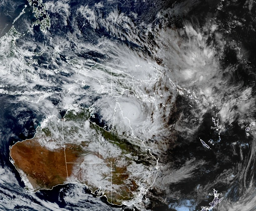
Satellite image of Tropical Cyclone Narelle at 07:20 UTC on March 19, 2026. Credit: JMA/Himawari-9, RAMMB/CIRA, The Watchers
Severe Tropical Cyclone Narelle was located approximately 240 km (149 miles) northeast of Cooktown and 355 km (221 miles) east of Coen, moving west at 27 km/h (17 mph) while maintaining Category 5 intensity at 16:00 AEST (06:00 UTC) on March 19.
10-minute maximum sustained winds near the center reached 220 km/h (137 mph), along with 3-second gusts of 315 km/h (196 mph) and an estimated minimum central pressure of 926 hPa.
Narelle is forecast to make landfall between Lockhart River and Cape Melville on the morning of March 20 as a Category 5 cyclone, although slight weakening to a high-end Category 4 remains possible immediately before landfall.
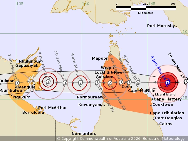

Very destructive wind gusts of more than 250 km/h (155 mph) are forecast near the cyclone’s center at landfall, with damaging to destructive winds expected across parts of Cape York Peninsula away from the core.
Damaging wind gusts of around 120 km/h (75 mph) are forecast across parts of the region between Lockhart River and Cooktown, with impacts potentially extending farther south toward Cape Tribulation depending on the cyclone’s track.
The system is forecast to bring widespread rainfall totals of 100 to 350 mm (4 to 14 inches) within 24 hours along and near the track. This heavy rain could trigger flash flooding across affected areas, including locations west of Coen and across northern parts of the peninsula.
Coastal hazards are expected to include abnormally high tides, large waves, and dangerous storm tides near the landfall area. Princess Charlotte Bay is a location of particular concern, where tides may rise significantly above normal levels and cause dangerous flooding in low-lying coastal areas.
The warning zone includes coastal and inland communities between Lockhart River and Cape Tribulation, as well as areas between Mapoon and Pormpuraaw, including Cooktown, Coen, Weipa, and Aurukun. Residents have been advised to finalize preparations and secure property ahead of the cyclone’s arrival.
Narelle is forecast to weaken after landfall as it tracks westward across the Cape York Peninsula on March 20 before emerging into the Gulf of Carpentaria later in the night into March 21.
Environmental conditions over the Gulf of Carpentaria are expected to support re-intensification, with the system forecast to strengthen again before approaching the eastern Northern Territory during the weekend.
Further westward movement is expected through the Northern Territory, where heavy rainfall, damaging winds, and elevated coastal water levels may develop from late March 21 into 22.
Beyond the weekend, forecast guidance indicates the system could continue toward the Joseph Bonaparte Gulf and possibly the Kimberley region early next week, although confidence in this longer-range track remains lower.
References:
1 Tropical Cyclone Forecast Track Map – BoM – March 19, 2026
2 Tropical Cyclone Technical Bulletin – BoM – March 19, 2026
3 Tropical Cyclone Advice – BoM – March 19, 2026

I am an Assistant Editor and Severe Weather & Science Journalist at The Watchers, specializing in real-time severe weather coverage, geophysical event reporting, and research-driven scientific analysis. You can reach me at rishav(at)watchers(.)news.
Commenting rules and guidelines
We value the thoughts and opinions of our readers and welcome healthy discussions on our website. In order to maintain a respectful and positive community, we ask that all commenters follow these rules.