
Kona low brings extreme rainfall to Maui and Oʻahu, causing flooding and landslides across Hawaiʻi
A slow-moving Kona low brought extreme rainfall to the Hawaiian Islands between March 10–16, 2026, producing record-breaking totals at multiple long-term stations, particularly on Maui and Oʻahu. Honolulu and Kahului both set new daily rainfall records on March 13, while multi-day accumulations on Maui reached up to about 1 170 mm (46 inches), triggering flooding, landslides, and widespread disruption.

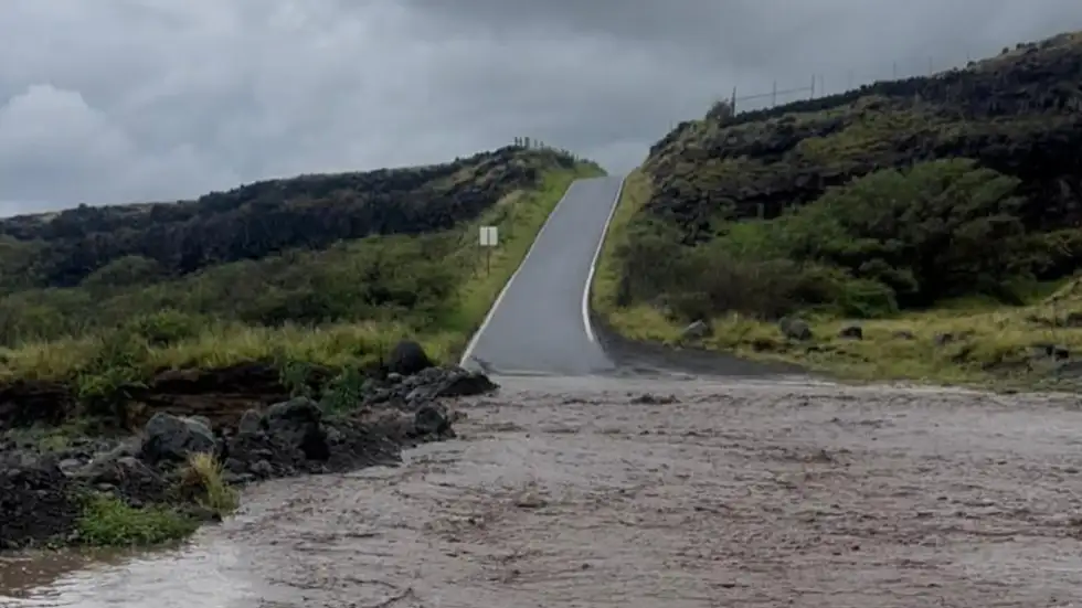
Flooding from days of downpours in Hana, Hawaii, on Friday, March 13, 2026. Credit: Maui County
A Kona low affected the Hawaiian Islands from March 10 to 16, producing prolonged heavy rainfall, thunderstorms, and strong winds as it moved slowly near the state. Kona lows form when winds shift to a southwesterly or westerly direction, reversing the typical northeast trade wind pattern and allowing deep tropical moisture to spread across the islands.
This reversal of the usual wind pattern often brings heavy rainfall to normally drier leeward areas. Honolulu, which averages about 417 mm (16.41 inches) of rainfall annually, received more than 200 mm (8 inches) during the event, underscoring the intensity of the system.
Rainfall rates reached 25–50 mm/h (1–2 inches per hour) in parts of Maui, Molokaʻi, and Hawaiʻi Island, according to the Hawaiʻi Emergency Management Agency. The persistence of rain bands over several days led to exceptional accumulation totals, particularly on Maui and Oʻahu.
Although Kona lows are typically associated with impacts on the leeward Kona side of Hawaiʻi Island, the most extreme rainfall and record-breaking totals during this event were concentrated on Maui and Oʻahu.
Terrain-driven uplift over the West Maui Mountains and the Koʻolau Range, combined with repeated rain bands, produced significantly higher accumulations than those observed along the Kona coast.
On Maui, multiple locations recorded extreme multi-day totals, with one location measuring approximately 1 170 mm (46 inches) of rainfall between March 10 and 15, according to National Weather Service (NWS) data.
Additional high totals included 1 127 mm (44.37 inches) at Kula and 879 mm (34.59 inches) at Kamehamenui. Across the state, significant accumulations were also recorded, including 646 mm (25.45 inches) at Mauna Loa on Hawaiʻi Island, 492 mm (19.38 inches) at North Wailua Ditch on Kauaʻi, and 490 mm (19.27 inches) at Schofield Barracks on Oʻahu.
Daily rainfall records were broken on March 13 at key long-term stations. In Honolulu, 140 mm (5.51 inches) fell within 24 hours, surpassing the previous record of 83.8 mm (3.3 inches) set in 1951. At Kahului Airport on Maui, 188 mm (7.4 inches) was recorded, marking the highest daily total since record-keeping began in 1954 and exceeding the previous record of 163 mm (6.4 inches) set on December 20, 2017.
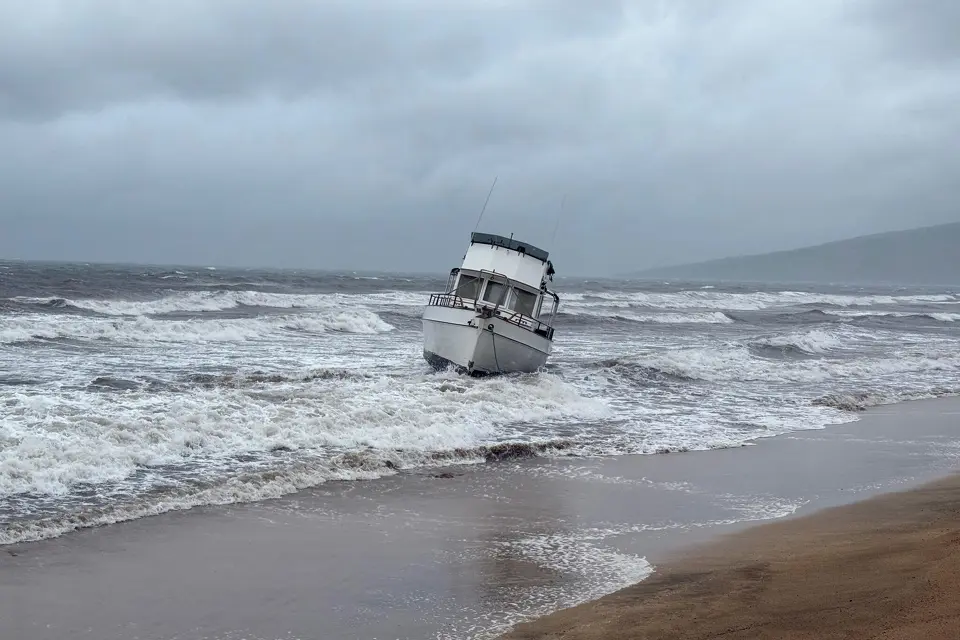
The heavy rainfall caused widespread flooding across multiple islands, including Kauaʻi, Oʻahu, Maui, Molokaʻi, Lānaʻi, and Hawaiʻi Island, with impacts reported from Hanalei to Kihei to Hilo. Flash flooding inundated roads and urban areas, while saturated ground conditions triggered landslides, debris flows, and sinkholes.
Maui County Mayor Richard Bissen reported flooding, landslides, debris, and downed power lines across the county, with multiple roads damaged or washed out.
Sections of Honoapiʻilani Highway in West Maui were closed due to flooding and debris near the Kuihelani intersection, stranding travelers and contributing to extended congestion. Airports across the state, including Kahului and Daniel K. Inouye International Airport in Honolulu, experienced delays and cancellations, with disruption continuing for several days.
Emergency response teams conducted multiple floodwater rescues as conditions deteriorated. Video released by Maui County showed washed-out roads, vehicles trapped in floodwaters, and widespread debris.
In Maui’s Iao Valley, residents Tom and Carrie Bashaw reported that rising water destroyed part of their home, with the rear section collapsing after nearby trees were uprooted.
“In the 20 years I’ve been here, I’ve never seen this much rain,” said Maui resident Jesse Wald, describing conditions as comparable to a thunderstorm but “times 10.”
Power outages affected multiple islands, with Hawaiian Electric reporting about 121 020 customers without electricity at 4:00 p.m. HST on March 13. Restoration continued in the following days, though some disruptions persisted during the early recovery phase.
Officials also monitored rising water levels at Wahiawā Reservoir on Oʻahu as conditions approached thresholds that could prompt evacuation warnings.
According to statements from Governor Josh Green, the worst of the Kona low has passed, but impacts continued across Maui County and Hawaiʻi Island, where showers, strong winds, and flooding remained possible on saturated ground. Flood Watch conditions remained in effect for these areas as recovery operations began.
The Kona low also produced winter weather conditions at higher elevations. Up to 500 mm (20 inches) of snow was reported on the summits of Mauna Kea, where snow and ice caused observatory cameras to stop functioning.
Strong winds accompanied the system, with gusts reaching 217 km/h (135 mph) at Kaiaulu Puu Waawaa on Hawaiʻi Island and exceeding 170 km/h (105 mph) in parts of Maui, contributing to damage and power outages.
NWS meteorologist Thomas Vaughan said the event involved exceptional rainfall totals. “We’re talking about a lot of water,” he said, warning that additional rainfall would continue to pose a risk in already saturated areas.
Authorities urged residents to avoid flooded roadways and follow emergency guidance as conditions slowly improved, repeating the message: “Turn around, don’t drown.”
Meteorologists are also monitoring a second storm system developing west of Hawaiʻi, expected to begin affecting the islands on March 19 and continue into March 22. Although it is forecast to be weaker than the previous storm, forecasters warned that even moderate rainfall could trigger flooding and landslides because soils remain saturated and stream levels are elevated.
In a statement posted on social media, Governor Josh Green said he declared a State of Emergency ahead of the incoming system to ensure state and county agencies are prepared to respond quickly and maintain public safety.
Recovery operations are ongoing across the state as officials continue to monitor conditions and prepare for the potential impacts of the next storm system.
References:
1 Hawaii rainfall summary – NOAA – March 18, 2026

I’m a science journalist and researcher at The Watchers, contributing to the Epicenter edition, where I cover peer-reviewed scientific research and emerging discoveries across Earth and space sciences. With a background in astronomy and a passion for environmental science, I’ve worked in shark and coral conservation in Fiji, conducting reef and shark-behavior research, contributing to mangrove restoration, and earning PADI Open Water and Coral Reef Certifications. I bring a blend of scientific rigor and storytelling to illuminate the discoveries shaping our planet and beyond.
Commenting rules and guidelines
We value the thoughts and opinions of our readers and welcome healthy discussions on our website. In order to maintain a respectful and positive community, we ask that all commenters follow these rules.