
Storm Therese brings heavy rainfall, flood and landslide risk to Canary Islands, Spain
Storm Therese began affecting the Canary Islands, Spain, on March 19, 2026, bringing strong winds, heavy rain, rough seas, and snowfall at high elevations. The severe weather is forecast to persist until at least March 2, with rainfall totals of over 300 mm (12 inches) being forecast in parts of La Palma and Tenerife, increasing the risk of flooding and landslides. Meanwhile, wind gusts above 90 km/h (56 mph) and waves over 5 m (16 feet) are expected.
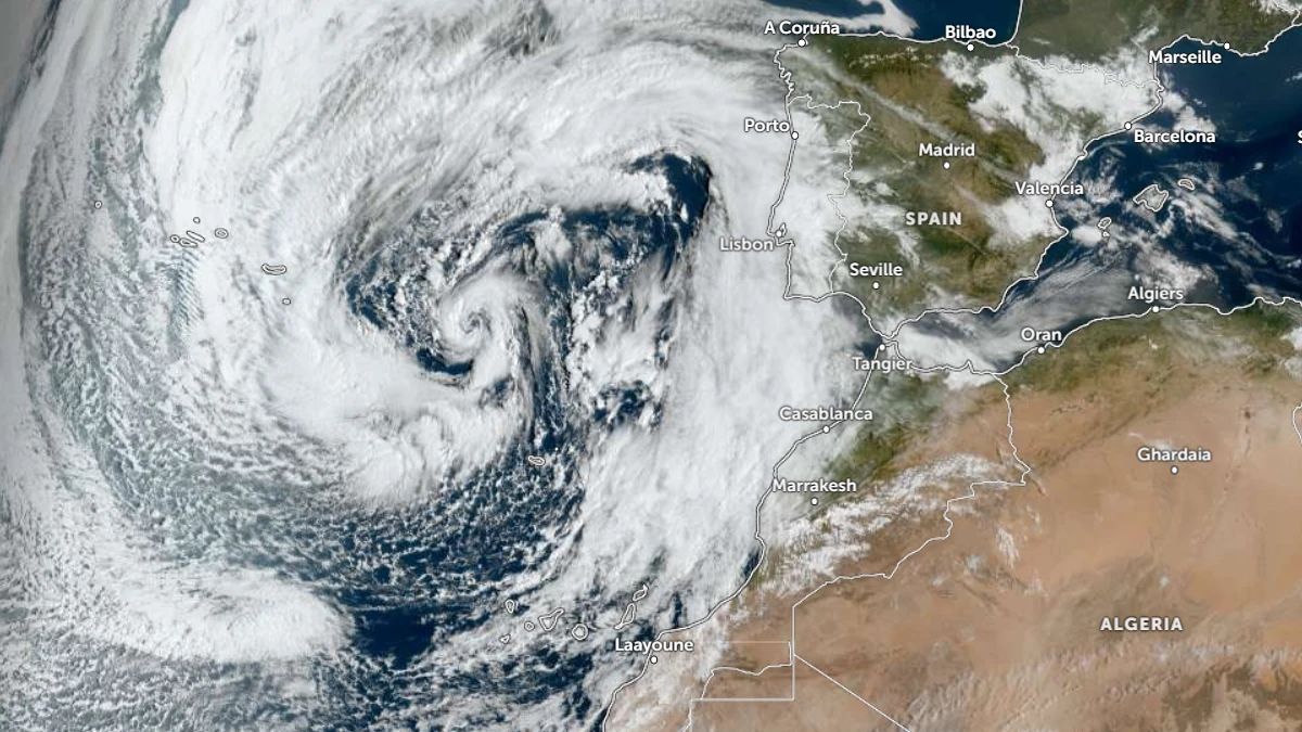
Satellite image of Storm Therese at 09:30 UTC on March 19, 2026. Credit: EUMESAT/METEOSAT, Zoom Earth, The Watchers
Storm Therese began affecting the Canary Islands on March 19, as an isolated cold low positioned to the northwest of the archipelago, generating a multi-day severe weather event across the region. The system’s impacts are forecast to persist until at least March 22, with a high probability exceeding 70%.
The synoptic configuration is characterized by a deepening cut-off low west of the Iberian Peninsula, driving successive frontal systems across the islands. This setup supports sustained atmospheric instability and enhanced moisture transport, with terrain-induced uplift contributing to intensified precipitation over high-relief areas, particularly on the western islands.
AEMET indicates that precipitation will intensify from March 19 onward, becoming strong to very strong and persistent, especially across La Palma and Tenerife.
The northern coast, the south-west, and high-altitude areas will be most vulnerable. The corridor between Santiago del Teide and Arico is expected to face the most severe conditions. Urban centers, including Santa Cruz and La Laguna, may also see disruption, though impacts there are forecast to be less intense.
The Tenerife Island Council announced the activation of its Island Emergency Plan (PEIN) from 15:00 LT on March 18, and it is expected to remain in effect through March 22.
Mount Teide National Park has been closed above 1 800 m (5 900 feet) due to heavy snow and ice. All forest tracks, recreational areas, and hiking paths are closed to reduce the risk of accidents and exposure to landslides.
The TF-445 road leading to Punta de Teno has been closed due to the risk of falling debris and coastal surges. Public outdoor activities and events have been suspended until conditions improve.
Accumulated rainfall totals of over 300 mm (12 inches) are forecast, particularly along midlands, summits, and southwest-facing slopes. The expected rainfall will produce rapid runoff in steep terrain, increasing the likelihood of flooding in ravines and low-lying urban zones, as well as landslides that may disrupt road networks.
Westerly to southwesterly flows will generate very strong gusts of over 90 to 100 km/h (56 to 62 mph) in exposed high-altitude areas and on leeward slopes, with widespread gusts around 70 km/h (43 mph) elsewhere. Winds from the storm are also pulling in Saharan dust, bringing orange skies to some areas.
A combined sea state will develop, with wave heights generally exceeding 4 m (13 feet) across affected waters and surpassing 5 m (16 feet) in western and southern coastal areas of La Palma and around El Hierro. These conditions are expected to produce hazardous coastal environments and disrupt maritime operations.
Snowfall is expected at higher elevations as the snow level drops to approximately 1 800–1 900 m (5 900–6 200 feet). Significant accumulations are likely on the summits of Tenerife and La Palma, supported by sub-zero temperatures observed at high-altitude stations, including −4.5°C (23.9°F) at Izaña.
Wind gusts of 88 km/h (55 mph) at Izaña and 86 km/h (53 mph) at Vallehermoso were observed as of 09:22 LT on March 19. Early rainfall totals remain modest, with up to 13.8 mm (0.54 inches) recorded at El Paso and 11.8 mm (0.46 inches) at Puntagorda, indicating that the event is still developing.
Rainfall is forecast to expand eastward on March 20 as the initial frontal system crosses the archipelago, followed by renewed instability associated with another frontal band.
Persistent precipitation is expected to continue through the weekend, particularly across mid-elevation zones and windward slopes of the western islands. Wind intensity is forecast to remain elevated through March 21, with gradual weakening expected by March 22, although locally strong gusts may persist in exposed areas.
References:
1 Weather summary – AEMET – March 19, 2026
2 Special Adverse Event Notice number 13/2026 – AEMET – March 19, 2026
3 The Cabildo activates the PEIN before the arrival of the Therese storm that will affect Tenerife until next Sunday – Cabildo de Tenerife – March 18, 2026

I am an Assistant Editor and Severe Weather & Science Journalist at The Watchers, specializing in real-time severe weather coverage, geophysical event reporting, and research-driven scientific analysis. You can reach me at rishav(at)watchers(.)news.
Commenting rules and guidelines
We value the thoughts and opinions of our readers and welcome healthy discussions on our website. In order to maintain a respectful and positive community, we ask that all commenters follow these rules.