
Powerful Kona low prompts emergency proclamations as Hawaii faces multi-day flood and severe storm threat
A powerful Kona low is bringing a multi-day flood and severe weather threat to Hawaii on Wednesday, March 11, 2026, with the most dangerous conditions forecast for Friday into Saturday. The National Weather Service says the storm could produce flash flooding, damaging winds, and strong to severe thunderstorms across the island chain, while Governor Josh Green has issued two emergency proclamations tied to the event.

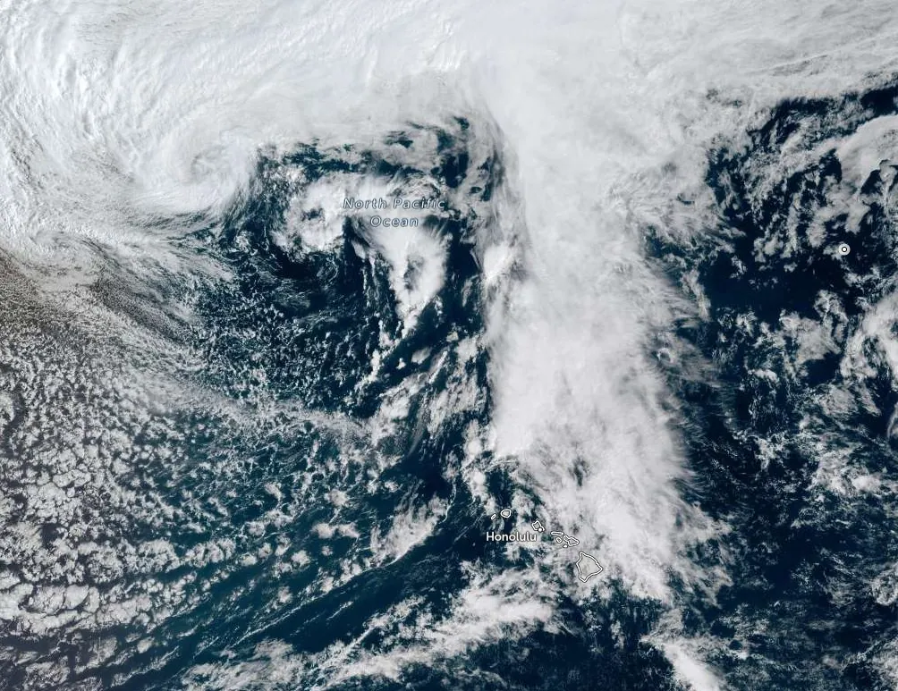
Satellite image of Kona low affecting Hawai'i at 20:00 UTC on March 11, 2026. Credit: NOAA/GOES-West, Zoom Earth, The Watchers
NWS/WPC warns a high-impact and potentially life-threatening weather pattern will continue to unfold across Hawaii into early next week.
A powerful Kona low northwest of Hawaii is producing a prolonged severe weather pattern across the state, with flash flooding, damaging winds, and strong to severe thunderstorms forecast through the weekend.
The National Weather Service in Honolulu said the western end of the island chain would be affected first before impacts spread eastward, while the peak of the event is forecast for Friday and Saturday, March 13 and 14.
Governor Josh Green issued an emergency proclamation ahead of the storm and a second proclamation tied to the same event, with the governor’s office saying the declarations were intended to support statewide preparation, response, and recovery measures for the March 2026 Kona low weather event.
Forecast discussions from the Honolulu office describe the event as a high-impact Kona storm that began with heavy rain over Kauai and Oahu.
Early on March 11, radar showed bands of showers lifting north across the state, with peak rainfall rates between 25.4 and 50.8 mm (1 and 2 inches) per hour in the initial bands, while several streams had already become elevated after overnight rainfall.
A short-term update later that morning said embedded convective elements were producing rates up to 38.1 mm (1.5 inches) per hour, with 12-hour totals reaching 147.6 mm (5.81 inches) at North Wailua Ditch on Kauai.
The larger-scale pattern remains favorable for repeated rounds of heavy rain and thunderstorms. The Weather Prediction Center (WPC) said the storm center was positioned a little over 1 600 km (1 000 miles) northwest of the island chain early March 11, with surface pressures at or below 990 hPa.
Aloft, forecasters identified a negatively tilted trough and a 222–259 km/h (138–161 mph) jet streak, a configuration expected to support significant upper-level divergence and organized convection with embedded thunderstorms for several days.
WPC said precipitable water values of 44.5–50.8 mm (1.75–2 inches) would expand eastward across the islands on Wednesday and Thursday before peaking at more than 50.8–57.2 mm (2–2.25 inches) by Friday and Saturday, when forcing aloft is expected to be strongest.
The center warned that additional heavy rainfall over already saturated soils would raise the risk of flash flooding as the event matures.
The Honolulu forecast office warned that the second phase of the storm could bring stronger winds and more dangerous convection later in the week. Its March 11 discussion said south to southwest winds may strengthen Friday into the weekend as the pressure gradient tightens between the low to the northwest and high pressure to the northeast, creating the potential for strong and damaging kona winds, including localized downslope winds capable of downing trees and power lines.
Additionally, environmental conditions may periodically become favorable for strong to severe thunderstorms, particularly Friday into Saturday, with storms capable of producing damaging winds, large hail, and possibly a tornado.
Flood watches covered the island chain today, with timing varying slightly by zone, while the Honolulu forecast discussion listed a High Wind Watch for Haleakala Summit and the Big Island summits from Thursday evening through Sunday afternoon, along with a Winter Storm Watch for the Big Island summits from Thursday evening through Saturday afternoon.
Kona low is a cut-off low-pressure system that typically forms northwest of Hawaii and reverses the usual trade-wind pattern, drawing deep tropical moisture northward toward the islands.
March falls within the late-wet-season period when Kona lows remain climatologically plausible in Hawaii, so the timing is in season even though the forecast moisture and multi-day impacts are unusually high for this point in the year.
References:
1 Hawaii Extended Forecast Discussion – NWS/WPC – March 11, 2026
2 Area Forecast Discussion – NWS/WPC – March 11, 2026
3 Proclamation Relating to March 2026 Kona Low Weather Event – Office of the Governor/State of Hawai’i – Accessed March 11, 2026
I'm a dedicated researcher, journalist, and editor at The Watchers. With over 20 years of experience in the media industry, I specialize in hard science news, focusing on extreme weather, seismic and volcanic activity, space weather, and astronomy, including near-Earth objects and planetary defense strategies. You can reach me at teo /at/ watchers.news.
Commenting rules and guidelines
We value the thoughts and opinions of our readers and welcome healthy discussions on our website. In order to maintain a respectful and positive community, we ask that all commenters follow these rules.