
Long-duration atmospheric river raises flood risk in western Washington through March 21
A multi-day atmospheric river event affecting western Washington, United States, since March 15, 2026, is elevating flood potential as cumulative rainfall and snowmelt impact the regional river basins. Prolonged precipitation and high snow levels are leading to rising rivers, with flood risk expected to persist through early March 21.
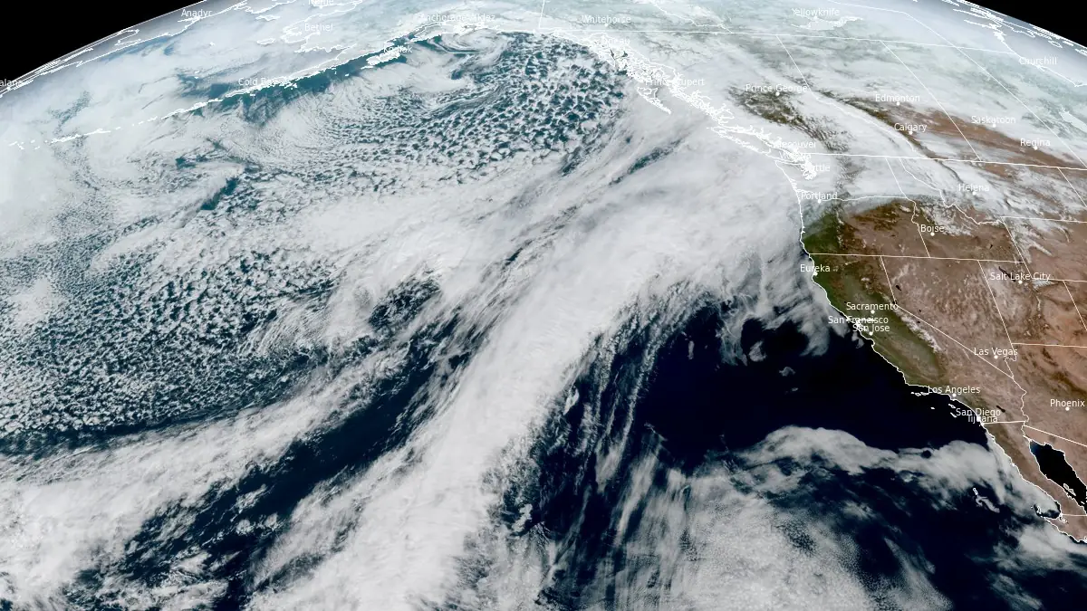
Satellite image of atmospheric river affecting British Columbia and Washington at 20:40 UTC on March 18, 2026. Credit: NOAA/GOES-West, RAMMB/CIRA, The Watchers
A long-duration atmospheric river continues to impact western Washington on March 18, raising the risk of river flooding through early Saturday, March 21.
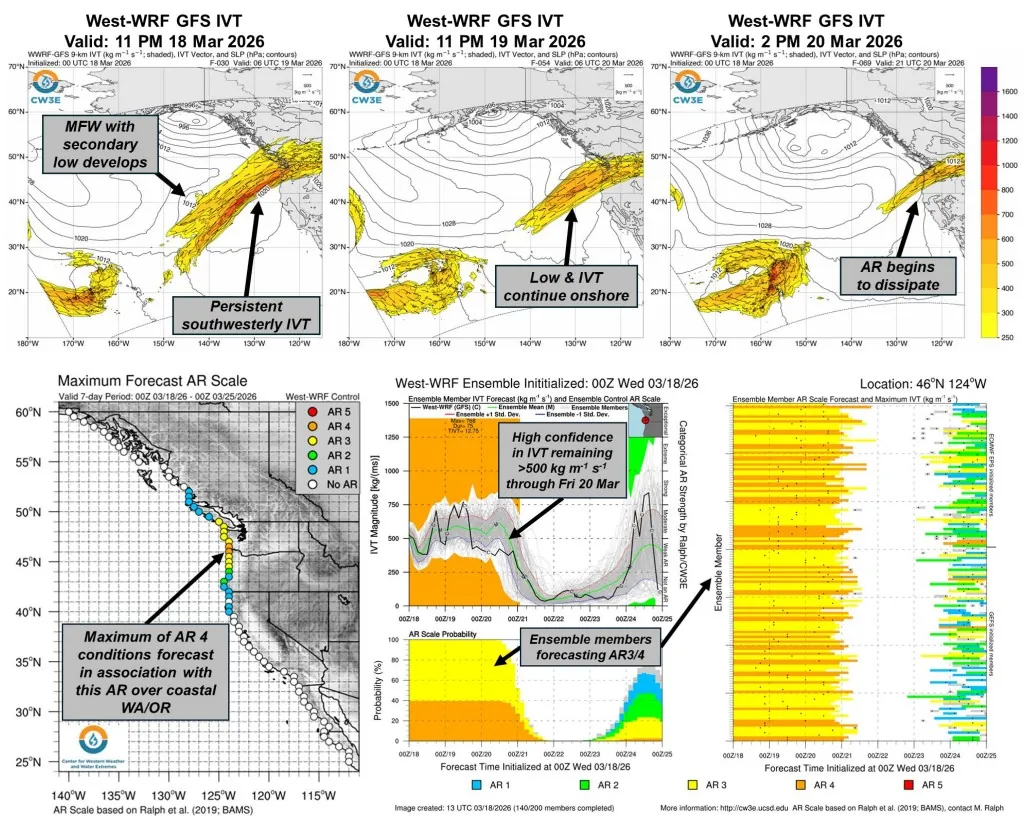
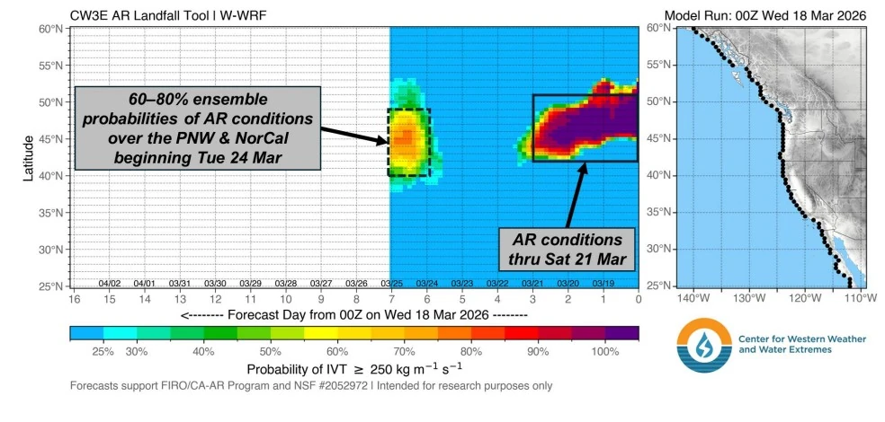
The system made landfall over British Columbia and the Pacific Northwest on March 15 and has maintained a persistent corridor of moisture transport into Washington State. Forecast guidance indicates that atmospheric river conditions are likely to persist for more than 72 hours, supported by repeated pulses of integrated vapor transport exceeding 500 kg m⁻¹ s⁻¹.
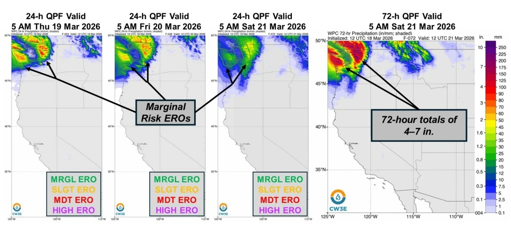
Forecast precipitation totals remain concentrated over the Olympic Peninsula and the northern Washington Cascades, where an additional 75–125 mm (3–5 inches) is expected over the Olympic Peninsula and 125–175 mm (5–7 inches) over the Cascades for the three-day period ending early March 21.
Localized higher totals are possible in terrain-favored areas due to orographic enhancement under sustained moist flow.
The primary hazard is not short-duration rainfall intensity but the prolonged accumulation of precipitation combined with elevated freezing levels. Snow levels near 2 400 m (8 000 feet) are allowing rainfall to extend into higher elevations, promoting rain-on-snow processes and accelerating runoff into river systems.
Hydrologic forecasts indicate widespread river and stream rises across western and central Washington. Several basins are expected to approach or exceed flood thresholds, with some locations forecast to reach moderate flood stage and others reaching minor flood stage or action levels in the coming days, according to regional forecast guidance.
Operational guidance from the National Weather Service (NWS) highlights the Olympic Peninsula and the Cascades as the most sensitive regions, where sustained precipitation and terrain effects are driving the highest runoff efficiency. River systems draining these areas are responding to both direct rainfall and snowmelt, increasing the likelihood of prolonged high flows rather than rapid flash flooding.
Excessive rainfall outlooks issued by the NWS Weather Prediction Center maintain a Marginal Risk across parts of Washington through early March 21.
A mesoscale frontal wave developing along the atmospheric river is forecast to reinforce moisture transport into the region through March 20, extending the duration of precipitation and sustaining elevated runoff rates. This additional forcing may prolong river responses even as peak rainfall rates remain moderate.
Anomalously warm conditions across the western United States are expected to persist into early next week, further enhancing snowmelt in affected basins. This thermal contribution continues to act as a secondary driver of runoff, particularly in mid-elevation terrain.
Ensemble guidance from the Center for Western Weather and Water Extremes (CW3E) indicates a 60–80% probability of another atmospheric river making landfall between central Washington and northern California around March 24–25.
While uncertainty remains regarding its exact trajectory and intensity, the potential for successive events introduces the risk of compounded hydrologic impacts in already saturated basins.
References:
1 Quick Look at the AR Impacting the Pacific Northwest – CW3E – March 18, 2026
I'm a dedicated researcher, journalist, and editor at The Watchers. With over 20 years of experience in the media industry, I specialize in hard science news, focusing on extreme weather, seismic and volcanic activity, space weather, and astronomy, including near-Earth objects and planetary defense strategies. You can reach me at teo /at/ watchers.news.
Commenting rules and guidelines
We value the thoughts and opinions of our readers and welcome healthy discussions on our website. In order to maintain a respectful and positive community, we ask that all commenters follow these rules.