
Atmospheric river forecast to stall over Washington, raising flood risk through March 20
An atmospheric river is forecast to stall over Washington through March 20, 2026, bringing an additional 127–254 mm (5–10 inches) of precipitation to the Olympic Peninsula and North Cascades. Freezing levels above 2 100 m (7 000 feet) are expected to keep nearly all precipitation falling as rain, accelerating snowmelt, and increasing the risk of flooding on some rivers and streams.
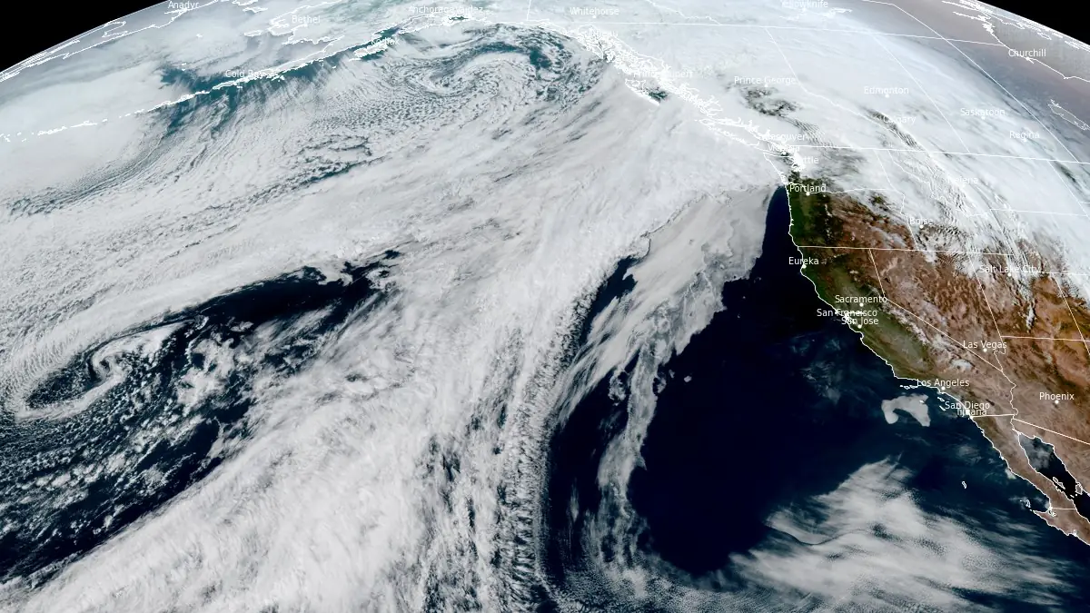
Satellite image of atmospheric river impacting British Columbia and Washington at 23:50 UTC on March 16, 2026. Credit: NOAA/GOES-18, RAMMB/CIRA, The Watchers
An atmospheric river (AR) impacting British Columbia is forecast to drift southward and stall over Washington and northern Oregon through March 20, supporting sustained moisture transport into the region, with some guidance extending conditions into early March 21.
The event is associated with a poleward surge of low-latitude moisture that made landfall over the region on March 15 before shifting northward into British Columbia under the influence of a mid-level ridge along the U.S. West Coast.
As the ridge weakens and a closed low moves into the Gulf of Alaska, the moisture plume is forecast to drift southward and stall over Washington, allowing prolonged precipitation to develop.
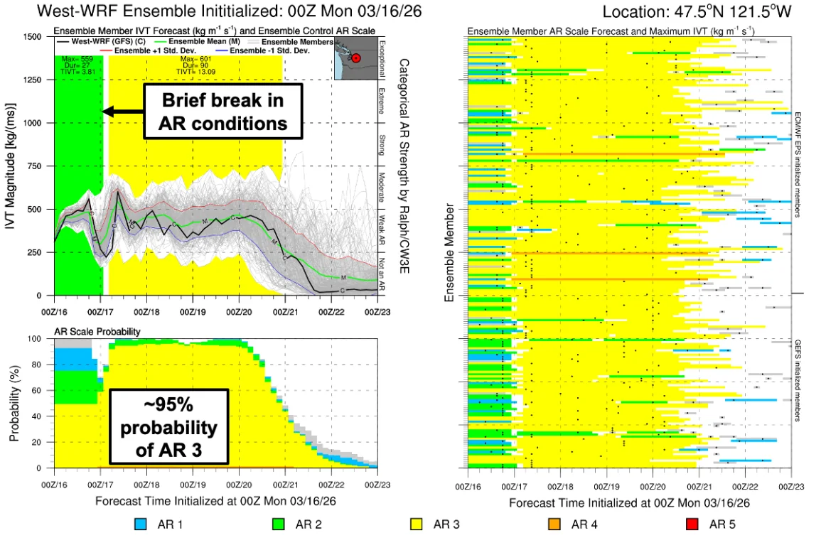
This pattern is expected to remain nearly stationary for several days, supporting a multi-day AR event with embedded frontal waves that will generate multiple pulses of enhanced integrated vapor transport (IVT). Periods of IVT exceeding 500 kg m-1 s-1 are likely during stronger phases, contributing to episodic increases in precipitation intensity.
Forecasts show high confidence in sustained AR conditions across coastal Washington, with over 90% probability for IVT ≥250 kg m-1 s-1 through late March 19. Moderate AR conditions (IVT ≥500 kg m-1 s-1) are also likely, with probabilities above 50% during key phases associated with the initial southward shift and subsequent moisture pulses.
AR 3–4 intensity is forecast along coastal Washington, with approximately 70% of ensemble members indicating AR 4 conditions. In the Cascade foothills near Snoqualmie Pass, AR 3 conditions are highly likely, supported by about 95% of ensemble members.
The AR impacts are forecast to last at least 72 hours of continuous moisture transport, with some models showing AR conditions persisting into early March 21.
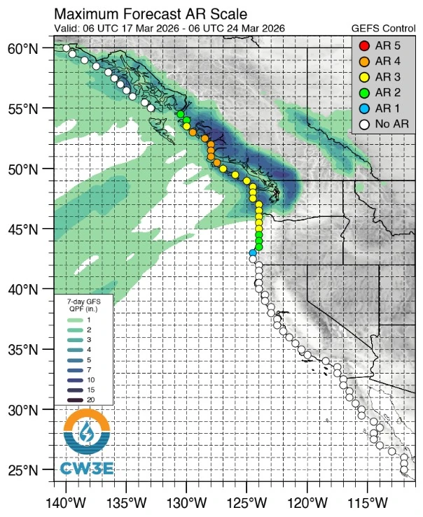
The heaviest precipitation is forecast over the Olympic Peninsula and North Cascades, where an additional 127–254 mm (5–10 inches) of rainfall is forecast by March 20.
Meanwhile, southern coastal Washington, the southern Cascades, and adjacent foothills are forecast to receive 51–127 mm (2–5 inches) during the same period.
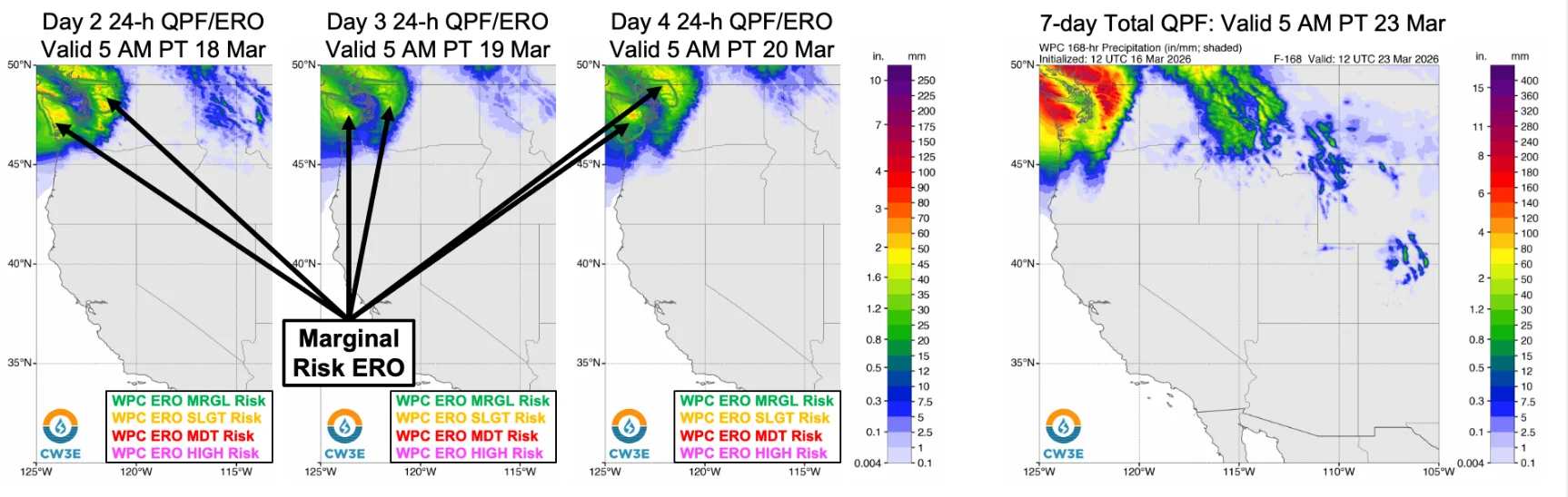
The Weather Prediction Center (WPC) has issued a Marginal Risk (level 1 of 4) in its excessive rainfall outlook for the Olympic Peninsula and North Cascades from March 17 through early March 20, indicating at least a 5% probability of flash flooding.
Freezing levels are forecast to remain above 2 100 m (7 000 feet) throughout the event after previously rising to 2 700–3 350 m (9 000–11 000 feet). The levels are high enough to keep nearly all precipitation falling as rain.
Forecast conditions will promote rain-on-snow processes across areas that received substantial snowfall during the previous week, accelerating snowmelt and increasing runoff efficiency. This is expected to enhance flood potential, particularly in basins with existing snowpack and steep terrain.
Rivers and streams across western and central Washington are forecast to rise in response to combined rainfall and snowmelt inputs. Forecast guidance from the Northwest River Forecast Center (NWRFC) indicates that four stream gauges are expected to exceed flood stage over the next 10 days, while numerous others are forecast to reach action or bankfull levels.
Hydrological forecasts indicate a 46% probability that the Tolt River near Carnation will exceed minor flood stage, with the most likely timing of initial flooding around March 18. Additional rises are possible later in the week in association with subsequent IVT pulses embedded within the AR.
Forecast models show varying precipitation totals and timing of peak intensity. The West-WRF configuration initialized with ECMWF data suggests a stronger and later final pulse of moisture transport, as well as prolonged AR conditions into early March 21, while GFS-based guidance indicates earlier dissipation by March 20.
In the Stillaguamish watershed, precipitation totals range from approximately 101 mm (3.97 inches) in GFS-based guidance to 163 mm (6.41 inches) in ECMWF-based guidance.
The same atmospheric river is also affecting British Columbia, where flood alerts have been issued and much higher rainfall totals are forecast in some coastal areas.
References:
1 Long-Duration Atmospheric River to Impact Washington This Week – CW3E – March 16, 2026
2 100 straight hours of rain: B.C.’s flood and avalanche risk raised – The Weather Network – March 17, 2026

I am an Assistant Editor and Severe Weather & Science Journalist at The Watchers, specializing in real-time severe weather coverage, geophysical event reporting, and research-driven scientific analysis. You can reach me at rishav(at)watchers(.)news.
Commenting rules and guidelines
We value the thoughts and opinions of our readers and welcome healthy discussions on our website. In order to maintain a respectful and positive community, we ask that all commenters follow these rules.