
Prolonged atmospheric river brings Flood Watch and high avalanche danger to British Columbia as some areas face up to 400 mm (15.7 inches) of rain
A prolonged atmospheric river is affecting parts of British Columbia this week, with Flood Watch, multiple rainfall warnings, and Special Weather Statements in effect across the province. Western Vancouver Island could receive up to 400 mm (15.7 inches) of rain in the wettest areas, while heavy rain on existing snowpack and rising freezing levels are increasing the risk of flooding, washouts, landslides, and high avalanche danger.
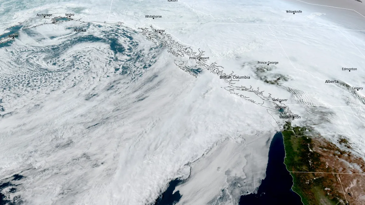
Satellite image of atmospheric river impacting British Columbia, Canada at 23:50 UTC on March 16, 2026. Credit: NOAA/GOES-West, RAMMB/CIRA, The Watchers
A Flood Watch remains in place for northern and western Vancouver Island and the Central Coast, while Environment Canada (EC) has issued multiple rainfall warnings across parts of the Central Coast, West Vancouver Island, the Fraser Valley, Howe Sound, Inland Vancouver Island, and parts of Metro Vancouver.
Special Weather Statements are also in effect for several inland areas, and a winter storm warning has been issued for Whistler.
Some parts of the B.C. coast could receive 50 to 400 mm (2–15.7 inches) of rain during this event. Forecast totals include 200 to 400 mm (7.9–15.7 inches) for Tofino and western Vancouver Island, 150 to more than 200 mm (5.9–7.9+ inches) for the North Shore Mountains, and 150 to 200 mm (5.9–7.9 inches) for Squamish.
EC has also issued a rainfall warning for coastal sections of the Central Coast south of Bella Bella near Rivers Inlet, where an additional 30 mm (1.2 inches) of rain is forecast on March 17.
The agency said prolonged heavy rain on snow, combined with mountain snowmelt, would lead to enhanced river responses and potential flooding, with extensive water pooling on roads, possible washouts, and an increased risk of landslides. Localized flooding is considered likely, and some roads could become impassable.
Elevated freezing levels, reaching about 2 000 to 2 500 m (6 560–8 200 feet) in some areas, are forecast to allow rain to fall on existing snowpack and accelerate mountain snowmelt. In southeastern parts of the province, EC said 25 to 45 mm (1–1.8 inches) of rain from Tuesday evening, March 17 into Wednesday afternoon, March 18, could produce localized flooding in valleys and other low-lying areas.
Warm temperatures, strong winds, and moderate to heavy precipitation are affecting the south and central coast, while rising snow levels are bringing rain into alpine terrain and increasing instability in mountain snowpack.
Preliminary rainfall totals provided by EC included 149 mm (5.9 inches) at Quatsino, 148.2 mm (5.8 inches) at Lennard Island, 142 mm (5.6 inches) at Estevan Point, and 124 mm (4.9 inches) at Kennedy Lake Highway Station. Maximum wind gusts reached 144 km/h (89 mph) at Sartine Island and 131 km/h (81 mph) at Solander Island.
Heavy snowfall was also recorded in parts of coastal and northwestern British Columbia before snow levels rose. The agency listed 42 cm (16.5 inches) near Stewart, 38 cm (15 inches) at Terrace, 38 cm (15 inches) at Onion Lake Highway Station, and 14 cm (5.5 inches) in the Whistler area during the March 15 to 16 period.
The combination of prolonged rainfall, saturated ground, elevated freezing levels, and ongoing snowmelt is expected to keep rivers and streams under pressure through the event, especially in coastal and mountain watersheds.
Additional alerts may be required later in the week as another period of more significant rainfall is expected in some parts of the province.
The same atmospheric river is also affecting Washington, where forecasters warned of prolonged moisture transport, high freezing levels, and an increasing risk of flooding through March 20.
In both British Columbia and Washington, the main concern is the same — heavy rain falling on existing snowpack, accelerating snowmelt, and increasing pressure on rivers, streams, and vulnerable mountain terrain.
References:
1 Weather Alerts for Canada – Environment Canada – Accessed March 17, 2026
2 Weather Summary for British Columbia – Environment Canada – March 17, 2026
3 100 straight hours of rain: B.C.’s flood and avalanche risk raised – The Weather Network – March 17, 2026
I'm a dedicated researcher, journalist, and editor at The Watchers. With over 20 years of experience in the media industry, I specialize in hard science news, focusing on extreme weather, seismic and volcanic activity, space weather, and astronomy, including near-Earth objects and planetary defense strategies. You can reach me at teo /at/ watchers.news.
Commenting rules and guidelines
We value the thoughts and opinions of our readers and welcome healthy discussions on our website. In order to maintain a respectful and positive community, we ask that all commenters follow these rules.