
Evacuation orders issued near Lytton as Saw Creek wildfire grows to 200 ha (494 acres), British Columbia, Canada
Authorities issued evacuation orders for areas east of the Highway 1 corridor near Lytton, British Columbia, as the Saw Creek wildfire grew to an estimated 200 ha (494 acres) on June 20, 2026. Officials warned that the out-of-control wildfire poses a significant risk to life as emergency operations continue south of the community.
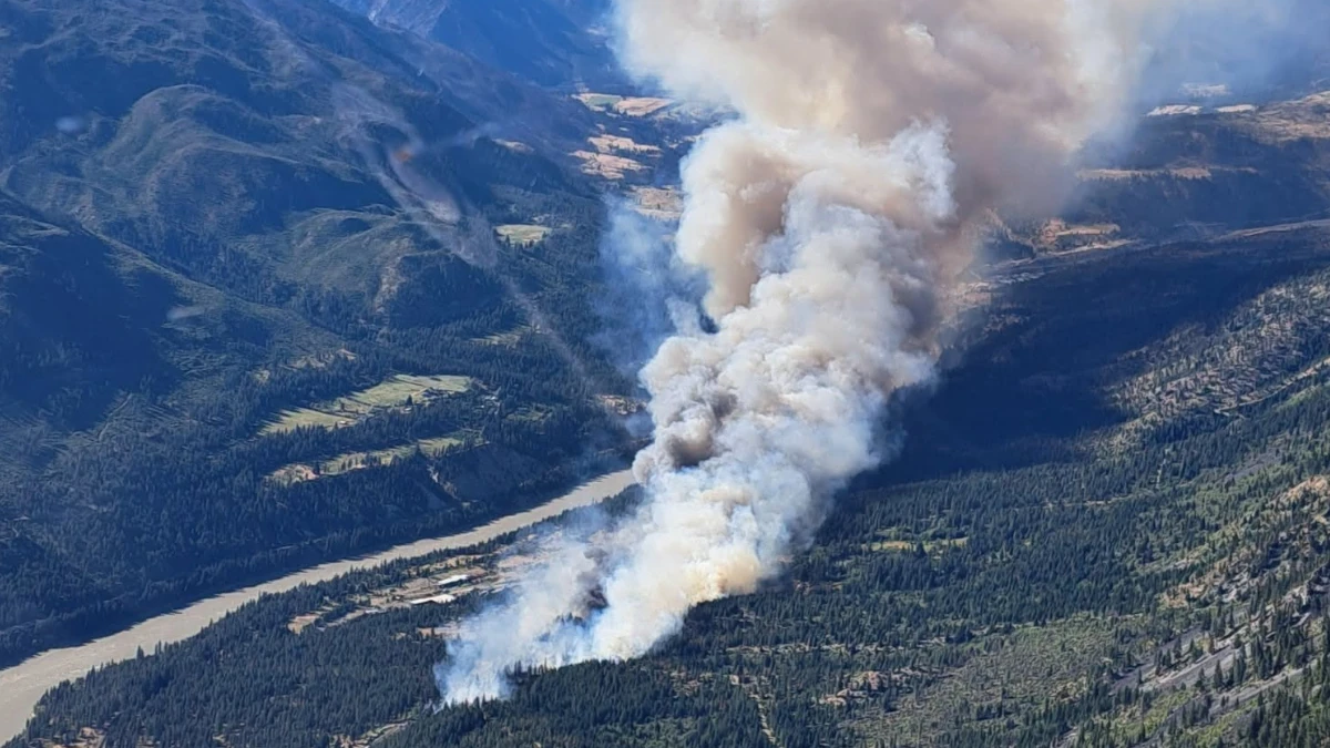
Saw creek fire near Lytton, British Columbia Canada on June 19, 2026. Credit: BC Wildfire Service
The Saw Creek wildfire (K70597) ignited on June 19 and is burning approximately 3 km (1.9 miles) south of Lytton near Highway 1. As the fire continued to spread, emergency officials ordered residents in several areas to leave immediately, while hundreds of others were placed on alert and told to prepare for possible evacuation.
A BC Emergency Alert issued at 22:10 LT on June 19, warned that the Saw Creek wildfire was creating a significant risk to life. The alert covered properties east of the BC Highway 1 corridor from Florence Road north to Lytton Airport. Evacuees were directed to the Battlefield Community Hall at 1756 Battlefield Road, while anyone unable to evacuate was instructed to call 9-1-1.
The Thompson-Nicola Regional District issued evacuation orders for a portion of the Village of Lytton and an area east of Highway 1 north and south of the community, including IR 17, IR 20, Kitzowitz, Ponderosa, and Loring Way. Authorities said residents within the evacuation zone must leave immediately because of the threat posed by the wildfire.
They also issued an evacuation alert for 168 properties within the Village of Lytton and two properties west of BC Highway 1. Residents in those areas were advised to be ready to leave on short notice if conditions deteriorate. Emergency officials noted that an evacuation order remains in effect for nearby areas.
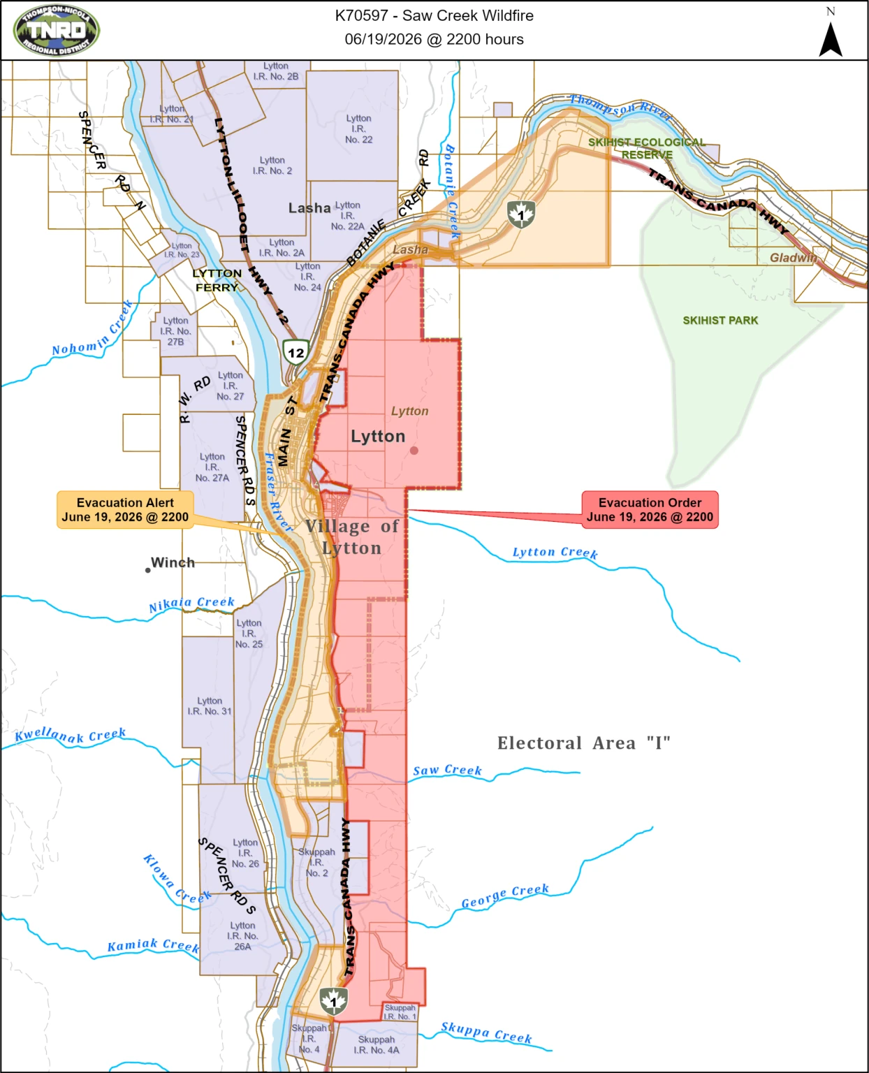
An evacuation alert was issued by Lytton First Nation for the area north of Klahkamich 17, where residents have been advised to prepare for immediate evacuation if conditions worsen. The First Nation also confirmed evacuation orders for IR 17 and IR 20 Kitzowitz.
DriveBC said that Highway 1 was closed in both directions just after 18:00 LT between Ashcroft and Boston Bar due to the fire. Commuters have been told to take the Coquihalla Highway or Highway 97C as alternate routes. There was no estimated reopening time for the stretch of Highway 1 in the Fraser Canyon, as of 21:00 LT on June 19.
The BC Wildfire Service classified the fire as “Out of Control”, meaning it is expected to spread beyond existing containment objectives. The agency also continues to list the incident as a Wildfire of Note, a designation reserved for highly visible wildfires or those that pose a potential threat to public safety, property, or critical infrastructure.
Emergency operations also remain active near Highway 1 because of the fire’s proximity to transportation infrastructure. Any specific highway closures or traffic restrictions should be verified directly through transportation authorities.
As of the latest information reviewed, provincial emergency authorities had not confirmed fatalities, injuries, or structural losses associated with the wildfire.
References:
1 Saw Creek – BC Wildfire Service – June 20, 2026
2 Evacuation Orders issued for Village of Lytton and BC Highway 1 corridor near Lytton – EmergencyInfoBC – June 19, 2026

I am an Assistant Editor and Severe Weather & Science Journalist at The Watchers, specializing in real-time severe weather coverage, geophysical event reporting, and research-driven scientific analysis. You can reach me at rishav(at)watchers(.)news.
Commenting rules and guidelines
We value the thoughts and opinions of our readers and welcome healthy discussions on our website. In order to maintain a respectful and positive community, we ask that all commenters follow these rules.