
Aspen Acres Fire destroys 155 structures, three Colorado wildfires burn over 25 000 ha (62 000 acres)
The Aspen Acres Fire destroyed at least 155 structures in Pueblo and Custer counties. This fire, together with Ferris and Gold Mountain fires burned a combined 25 077 ha (61 969 acres) across Colorado by late June 30, 2026. Critical fire weather conditions are forecast to continue supporting rapid fire growth through at least July 3.
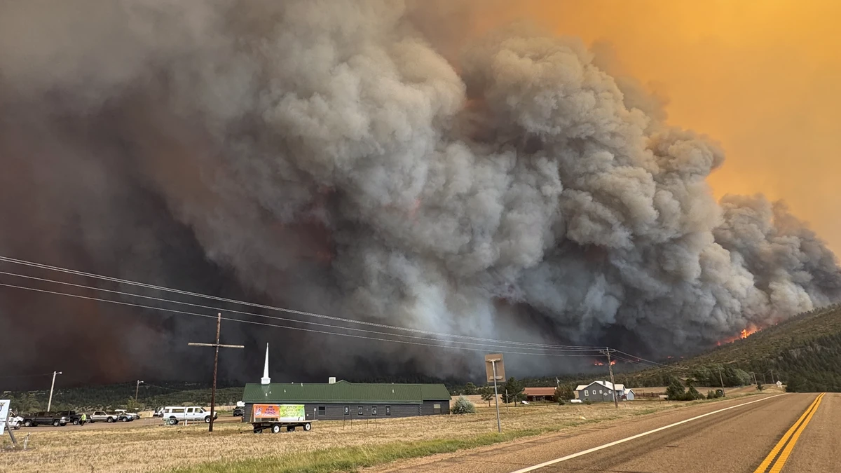
Smoke rising from the Aspen Acres Fire in Colorado on June 30, 2026. Credit: PCSO
The Aspen Acres Fire, which ignited on June 29, burned 11 457 ha (28 314 acres) as of 20:20 LT on June 30, according to the Pueblo County Sheriff’s Office (PCSO).
The blaze has destroyed over 100 structures in Pueblo County and 55 structures in Custer County. Authorities believe the fire was human-caused, while the Colorado Department of Fire Prevention and Control (DFPC) estimated preliminary damage at approximately USD 15 million.
Mandatory evacuation orders remained in effect for the towns of Beulah, Rye, and San Isabel, along with the Burnt Mill Road corridor east to Interstate 25 south of Lake Isabel.
Additional evacuation areas included a 3 km (2 mile) zone around San Isabel, the Highway 165 corridor from Lazy Acres to Bishop Castle, and the area extending from 12 Mile Road and 3R Road to Crow Cutoff.
Meanwhile, the Ferris Fire, burning in San Juan National Forest east of Cahone, scorched 8 611 ha (21 279 acres) with 0% containment by 22:21 LT on June 30, according to InciWeb.
The fire was first reported at approximately 15:04 LT on June 28 and is believed to have been caused by lightning. The Far Draw, Doe Canyon, and Ferris incidents were subsequently managed together under the Ferris Fire, based on the information available for this draft. DFPC estimated preliminary damage at approximately USD 991 000.
Evacuation orders were issued for Bradfield Bridge Campground and nearby areas along Highway 504 and Forest Service Road 521 to McPhee Dam in Montezuma County.
Private holdings in Glade Ranch were also evacuated. In neighboring Dolores County, evacuation orders covered private inholdings north of Glade Ranch, while pre-evacuation notifications extended east of Lone Mesa State Park to the Dolores–Norwood Road and north to just below Disappointment Road.
Northeast of Ouray, the Gold Mountain Fire burned 5 009 ha (12 376 acres) by 23:24 LT on June 30 after it was first reported at approximately 17:33 LT on June 27. The fire remained 0% contained, its cause was under investigation, and DFPC estimated preliminary damage at approximately USD 660 000.
Critical fire weather conditions are forecast to persist across much of Colorado through at least July 3. Multiple Red Flag Warnings and Fire Weather Watches remain in effect as a warm, dry air mass combines with gusty south to southwest winds and critically low relative humidity, creating conditions favorable for rapid wildfire ignition and spread across central, southern, and western parts of the state.
The National Weather Service (NWS) office in Denver/Boulder has a Red Flag Warning in effect from 12:00 MDT to 20:00 MDT on July 1 for South Park, the southern foothills, and the Palmer Divide, including Fire Weather Zones 214, 216, and 241.
Sustained south winds of 24–40 km/h (15–25 mph) with gusts up to 56 km/h (35 mph) and a minimum relative humidity of 8% will support critical fire weather.
The NWS office in Pueblo has Red Flag Warnings in effect from 10:00 MDT to 22:00 MDT on July 1 across Fire Weather Zones 220 through 230 and 233, covering the Upper Arkansas River Valley, Teller County, Fremont County, the San Luis Valley, Pueblo County, El Paso County, and Las Animas County.
Southwest winds of 24–40 km/h (15–25 mph) with gusts up to 64 km/h (40 mph), combined with minimum relative humidity as low as 5%, are expected to support rapid fire growth. Additional Red Flag Warnings remain in effect from 10:00 MDT on July 2 until 00:00 MDT on July 3, while Fire Weather Watches remain in place for July 3, indicating the threat of continued critical fire weather.
Across western Colorado, the NWS office in Grand Junction has Red Flag Warnings in effect from 12:00 MDT to 20:00 MDT on July 1 for multiple fire weather zones, including the Lower Colorado River, Colorado River Headwaters, Gunnison Basin, Northern San Juan Mountains, and portions of southwest Colorado.
South to southwest winds of 16–32 km/h (10–20 mph) with gusts up to 56 km/h (35 mph) and minimum relative humidity between 5% and 12% are expected to produce dangerous fire weather conditions. Fire Weather Watches also remain in effect for many of these areas on July 2.
The combination of strong winds, critically low humidity, and dry fuels is expected to support rapid fire spread and extreme fire behavior where new ignitions occur, maintaining elevated wildfire conditions across much of Colorado through at least July 3.
References:
1 Pueblo Emergency Status Board – PCSO – June 30, 2026
2 Ferris Fire – Inciweb – accessed at 10:00 UTC on July 1, 2026
3 Colorado Wildland Fire Status Dashboard – DFPC – accessed at 10:00 UTC on July 1, 2026
4 Red Flag Warnings – NWS – July 1, 2026

I am an Assistant Editor and Severe Weather & Science Journalist at The Watchers, specializing in real-time severe weather coverage, geophysical event reporting, and research-driven scientific analysis. You can reach me at rishav(at)watchers(.)news.
Commenting rules and guidelines
We value the thoughts and opinions of our readers and welcome healthy discussions on our website. In order to maintain a respectful and positive community, we ask that all commenters follow these rules.