
NWS confirms EF3 tornado in Effingham County, seven tornadoes confirmed across central Illinois
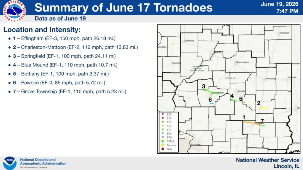
The National Weather Service (NWS) Central Illinois office confirmed seven tornadoes across central Illinois following severe thunderstorms on June 17, 2026, including an EF3 tornado with peak winds of 241 km/h (150 mph) that tracked 42.2 km (26.2 miles) through Effingham County and injured two people. The surveys documented tornadoes affecting portions of Effingham, Jasper, Coles, Menard, Sangamon, Christian, Macon, Shelby, and Moultrie counties.
The Effingham County tornado was the strongest and most destructive of the outbreak. It touched down near Beecher City at 06:26 and remained on the ground until 06:58, reaching a maximum width of 457 m (1 500 feet).
Survey teams assigned the tornado an EF3 rating and estimated peak winds of 241 km/h (150 mph). Two injuries were reported associated to the twister.
The tornado initially produced EF0 and EF1 damage along Illinois Route 33 near Beecher City, snapping and uprooting large trees and damaging grain silos and farm outbuildings.
As it moved east through Shumway, it intensified to EF2 strength, snapping hardwood and softwood trees roughly two-thirds of the way up their trunks, removing the roof from a single-family residence, and destroying multiple farm buildings.
The most severe damage occurred north of Effingham along East 1800th Avenue, where NWS investigators found EF3 damage, including the destruction of a single-family home that suffered complete exterior wall collapse.
Additional EF3 damage occurred at nearby farmsteads, where large outbuildings were demolished and homes sustained complete roof loss and structural failure. After crossing U.S. Highway 45 in Effingham, the tornado destroyed a large metal building following failure of an X-brace system and threw a delivery van approximately 137 m (450 feet).
The tornado continued southeast across Interstate 70 and into the Teutopolis area, where it caused major tree damage and complete roof loss at several homes.
Near the intersection of Highway 40 and North 1950th Street, survey teams documented the destruction of large barns and outbuildings and the complete removal of a residence roof.
The tornado maintained EF3 intensity into rural Teutopolis, where peak winds were estimated at 225 km/h (140 mph) near North 2100th Street and East 1500th Avenue. Two homes were destroyed before the tornado crossed into Jasper County, weakened to EF2 intensity, and eventually lifted north of Island Grove.
The second strongest tornado developed about 6 km (4 miles) north of Mattoon and tracked southeast toward Charleston. Rated EF2, the tornado reached estimated peak winds of 187 km/h (116 mph), remained on the ground for 22 km (14 miles), and reached a maximum width of 732 m (800 yards). One injury occurred when a semi-truck was overturned on Interstate 57.
Survey teams documented damage to homes, farm buildings, electrical transmission lines and trees before the tornado crossed through the north side of Charleston, damaging the fairgrounds, outbuildings, and additional trees before lifting east of the city along Illinois Route 16.
Five additional tornadoes were confirmed elsewhere in central Illinois. An EF1 tornado tracked 39 km (24 miles) from southern Menard County into Sangamon County, first touching down near Salisbury.
In addition to extensive tree damage, it damaged a garage and the roof of a nearby home before continuing through northern Springfield, where it damaged more trees and blew in the garage door of a business. Portions of the path followed the same track as an EF1 tornado that struck the area on June 10 before dissipating west of Mechanicsburg.
Another EF1 tornado developed in the Griswold Conservation Area in northern Christian County and crossed into Macon County near Blue Mound. The tornado caused extensive tree damage, damaged structures in town, tore part of the roof from Meridian Elementary School, destroyed two grain bins south of the school, and downed electrical transmission lines.
It continued across U.S. Route 51 and into Shelby County, causing additional damage to trees and transmission infrastructure before lifting northeast of Moweaqua. Survey teams estimated peak winds of 177 km/h (110 mph), a path length of 17 km (11 miles), and a maximum width of 640 m (2 100 feet).
NWS also documented an EF1 tornado southwest of Bethany with peak winds of 161 km/h (100 mph) and a 5.5 km (3.4 mile) path. The tornado snapped softwood trees, removed large branches from hardwood trees, crossed from Christian County into Moultrie County, and lifted south of Bethany.
A separate EF1 tornado formed in Grove Township in Jasper County after the Effingham tornado underwent a cycling process. The tornado caused major roof damage to a two-story house, rolled an SUV, damaged an outbuilding, and snapped several large hardwood trees near North 300th Street.
Additional damage occurred along East 1700th Avenue, where homes, mobile homes, trees, and agricultural structures sustained impacts before the tornado lifted east of North 800th Street. The tornado had estimated peak winds of 177 km/h (110 mph), a path length of 8.4 km (5.2 miles), and a maximum width of 160 m (175 yards).
The final tornado surveyed by NWS was an EF0 that touched down west of Pawnee Junction near the Interstate 55 exit and tracked east through Comanche Village and Pawnee before dissipating southeast of town.
The tornado primarily caused tree damage along its 9.2 km (5.7-mile) path, although minor roof and soffit damage was also reported. Estimated peak winds reached 137 km/h (85 mph), and no injuries occurred.
References:
1 June 17, 2026 Severe Weather – NWS – June 19, 2026
Featured image credit: representational image of Spiritwood/Urbana EF3 tornado on June 20, 2025. Credit: Tanner Charles, NWS

I am an Assistant Editor and Severe Weather & Science Journalist at The Watchers, specializing in real-time severe weather coverage, geophysical event reporting, and research-driven scientific analysis. You can reach me at rishav(at)watchers(.)news.
Commenting rules and guidelines
We value the thoughts and opinions of our readers and welcome healthy discussions on our website. In order to maintain a respectful and positive community, we ask that all commenters follow these rules.