
Severe storms and flash flooding forecast across the Plains, Midwest, and eastern U.S. through June 23
A multi-day severe weather outbreak is forecast to affect large portions of the central and eastern United States through Tuesday, June 23, 2026. Forecasters are warning of scattered to widespread flash flooding in parts of Nebraska, Kansas, and Missouri under a Moderate Risk of excessive rainfall, while severe thunderstorms capable of producing very large hail, damaging winds, and tornadoes develop across the Plains and Midwest.
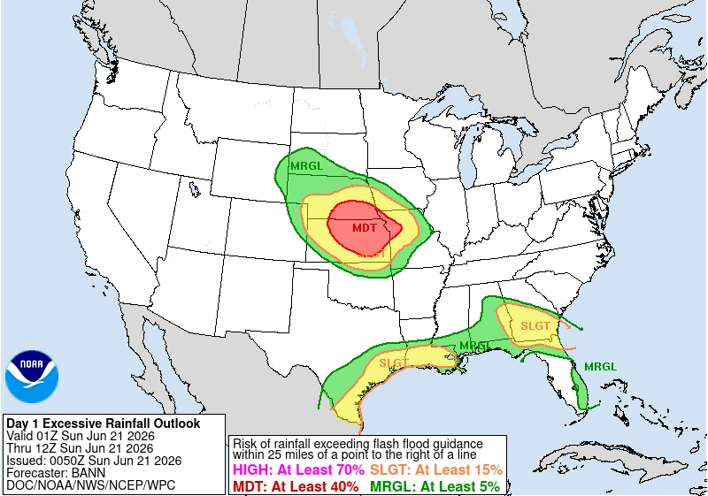
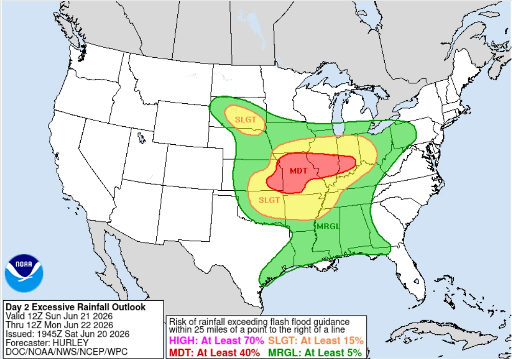
Google earth overlay of WPC day 1 ERO issued on June 21, 2026. Credit: NWS/WPC, Google Earth, The Watchers
An expansive storm system will bring multiple rounds of thunderstorms and excessive rainfall to the Plains, Midwest, Ohio Valley, Northeast, Gulf Coast, and southern Plains through early next week.
The Southeast will continue to face heavy rainfall and flash flood concerns, while dangerous heat and humidity persist across parts of the region.
The event began to organize on Saturday, June 20, as an upper-level disturbance helped deepen a surface low east of the Rocky Mountains. Strong southerly flow ahead of the system transported abundant Gulf moisture northward into the central Plains, creating a highly unstable environment favorable for widespread thunderstorm development.
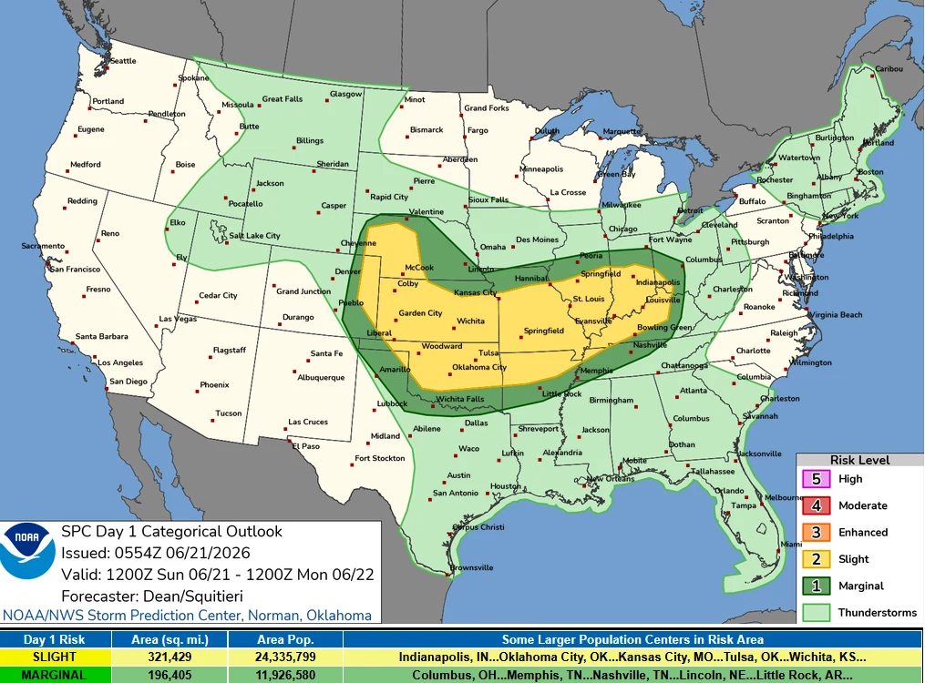
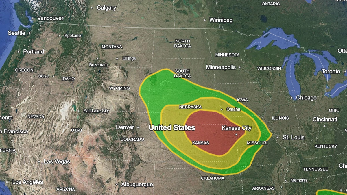
The Storm Prediction Center (SPC) maintained a Slight Risk (Level 2 of 5) for severe thunderstorms across portions of the central Plains on Saturday, due to the threat of large hail, damaging winds, and a few tornadoes.
Storms are forecast to intensify during the afternoon and evening before evolving into a larger organized convective system as a cold front advances eastward overnight. An Enhanced Risk (Level 3 of 5) covers northeastern Colorado, southern Nebraska, and northern Kansas, where stronger storms are forecast to produce very large hail and more widespread significant wind damage, according to the Weather Prediction Center (WPC).
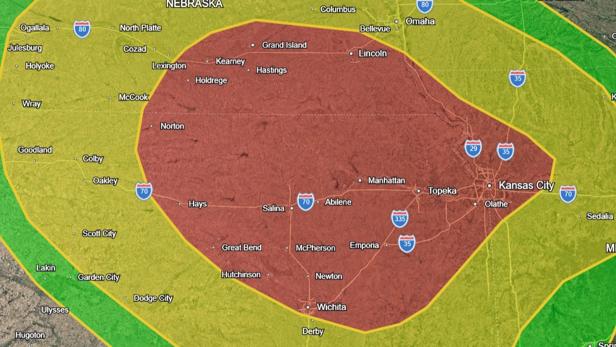
WPC has placed southeastern Nebraska, northeastern Kansas, and northwestern Missouri under a Moderate Risk (Level 3 of 4) for excessive rainfall, where scattered to widespread flash flooding is expected. A broader Slight Risk area extends across much of the central Plains and the Middle and Lower Missouri Valley, reflecting the potential for additional flash flood occurrences.
Thunderstorms are expected to continue on Sunday, June 21, as the storm system shifts eastward into the Middle Mississippi Valley and Lower Ohio Valley.
Additional storms are forecast to develop ahead of the advancing cold front across portions of the Missouri Valley and central Plains. The WPC continues to highlight a Moderate Risk of excessive rainfall in parts of the region, while severe thunderstorms capable of producing damaging winds, large hail, and tornadoes remain possible.
By Monday, June 22, the surface low is forecast to track into the Ohio Valley and toward the Northeast. Its trailing cold front will extend southwestward through the Tennessee Valley, Lower Mississippi Valley, and southern Plains, serving as a focus for widespread thunderstorm development.
The WPC forecasts a broad flash flood threat on Monday from the southern Plains through the Lower Mississippi Valley, Tennessee Valley, Ohio Valley, and into parts of the Northeast. A broad Slight Risk of excessive rainfall remains in place as repeated rounds of thunderstorms develop along and ahead of the frontal boundary.
Across the Gulf Coast and portions of the Southeast, deep tropical moisture interacting with a lingering frontal boundary will support numerous thunderstorms capable of producing intense rainfall rates. Locally significant flash flooding remains possible in areas that experience repeated storms. The WPC maintains a Slight Risk of excessive rainfall across parts of the region.
The severe weather threat is not confined to the central and eastern United States. Farther west, another upper-level disturbance moving through the Great Basin and northern Rockies is expected to generate scattered thunderstorms and gusty winds. Dry fuels, low humidity, and strengthening winds have prompted elevated fire weather concerns across parts of the Interior West.
Critical Fire Weather Risk (Level 2 of 3) has also been issued for portions of the eastern Great Basin and Four Corners region, surrounded by a broader Elevated Fire Weather Risk area.
Significant temperature contrasts are also forecast across the country. Heat and humidity will continue across the Southeast and portions of the southern Plains, where heat index values are expected to exceed 38°C (100°F). High temperatures above 38°C (100°F) are also forecast across parts of the southern High Plains.
Meanwhile, cooler air behind successive cold fronts will spread across the northern Plains, Upper Midwest, Great Lakes, and portions of the Northeast. High temperatures in many of these areas are expected to remain in the 21 to 26°C (70s°F) range through early next week.
Forecasters expect the combination of rich Gulf moisture, strong atmospheric instability, repeated thunderstorm development, and organized frontal forcing to maintain an elevated risk of flash flooding and severe weather across large sections of the United States through at least June 23.
Areas from the central Plains to the Ohio Valley remain at greatest risk for the most significant impacts, including severe thunderstorms capable of producing large hail, damaging winds, tornadoes, and scattered to widespread flash flooding.
References:
1 Short Range Forecast Discussion – NWS/WPC – June 20, 2026

I am an Assistant Editor and Severe Weather & Science Journalist at The Watchers, specializing in real-time severe weather coverage, geophysical event reporting, and research-driven scientific analysis. You can reach me at rishav(at)watchers(.)news.
Commenting rules and guidelines
We value the thoughts and opinions of our readers and welcome healthy discussions on our website. In order to maintain a respectful and positive community, we ask that all commenters follow these rules.