
Tropical Cyclone Narelle forms in Coral Sea, forecast to intensify before Queensland impact, Australia
Tropical Cyclone Narelle developed in the northern Coral Sea on Tuesday, March 17, 2026, with sustained winds of 85 km/h (53 mph) and gusts to 120 km/h (75 mph). The system is moving west-southwest toward Far North Queensland and is forecast to intensify to severe tropical cyclone strength before approaching the coast later this week, with damaging winds, heavy rainfall, and coastal flooding being forecast.
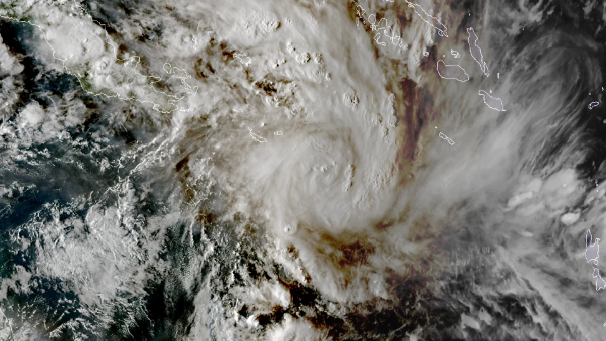
Satellite image of Tropical Cyclone Narelle at 07:10 UTC on March 17, 2026. Credit: GEO-Kompsat, RAMMB CIRA, The Watchers
Tropical Cyclone Narelle developed into a Category 1 system in the northern Coral Sea at 16:00 AEST (06:00 UTC) on Tuesday, March 17, approximately 790 km (491 miles) east-northeast of Willis Island and 1 240 km (771 miles) east-northeast of Cooktown. The system was moving west-southwest at 16 km/h (10 mph), steered by a subtropical ridge to the south.
Maximum sustained winds near the center averaged over 10 minutes were estimated at 85 km/h (53 mph), with gusts reaching 120 km/h (75 mph), and a minimum central pressure of 992 hPa. Satellite analysis shows well-established convective banding, with microwave imagery indicating an eyewall wrapping around the southern and western sectors of the circulation.
Environmental conditions are favorable for further intensification, with low vertical wind shear of approximately 10–20 km/h (6–12 mph), sea surface temperatures near 29–30°C (84–86°F), and sufficient deep-layer moisture supporting sustained convection. The system is positioned beneath an upper-level anticyclone, with upper-level outflow expected to improve as an upper trough approaches later in the week.
Forecasts show steady to rapid intensification as Narelle tracks westward toward Far North Queensland. The system is expected to approach the coast between Lockhart River and Port Douglas, with the potential to reach severe tropical cyclone intensity prior to landfall.
Forecast wind speeds reach up to 195 km/h (121 mph), although uncertainty remains in the timing of coastal interaction.
A Tropical Cyclone Watch is in effect for coastal and adjacent inland areas between Lockhart River and Port Douglas. No warning zone has been declared at this stage.
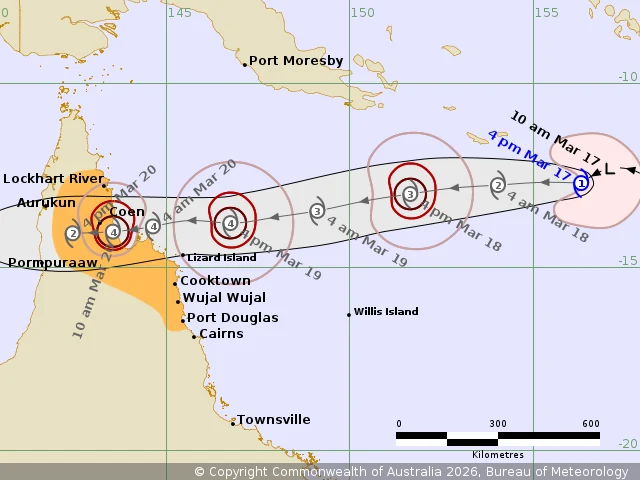
Destructive wind gusts of up to 155 km/h (96 mph) could develop between Coen and Cooktown from Thursday night, March 19, while damaging wind gusts up to 120 km/h (75 mph) are possible between Cape Melville and Port Douglas from early Thursday morning, extending northward to Lockhart River by Thursday afternoon.
Heavy rainfall is forecast across coastal areas between Cape Melville and Port Douglas from Thursday evening, extending inland during Friday, with potential for flash flooding. Locally intense rainfall is possible between Lockhart River and Cape Melville, as well as inland west of Coen.
Coastal impacts are expected to include above-normal tides and large waves, with minor flooding of low-lying coastal areas possible. In Princess Charlotte Bay, tides may rise significantly above normal high tide levels, with damaging waves and dangerous coastal flooding possible.
Forecast confidence remains high regarding the westward track of the system; however, there is variability in forward speed across model guidance. A faster track could result in earlier land interaction and reduced peak intensity, while a slower progression may allow further strengthening prior to landfall.
After crossing the Queensland coast, Narelle is expected to weaken while traversing the Cape York Peninsula. The system may then emerge over the Gulf of Carpentaria, where environmental conditions remain favorable, allowing for possible re-intensification before a subsequent landfall along the Northern Territory coast.
1 Tropical Cyclone Forecast Track Map – BoM – March 17, 2026
2 Tropical Cyclone Technical Bulletin – BOM – March 17, 2026
3 Tropical Cyclone Advice – BOM – March 17, 2026

I am an Assistant Editor and Severe Weather & Science Journalist at The Watchers, specializing in real-time severe weather coverage, geophysical event reporting, and research-driven scientific analysis. You can reach me at rishav(at)watchers(.)news.
Interesting seeing rotation evolve 00:00utc to 06:00utc. Think how much organised energy that takes.
Might we consider integrating space wx, magnetospheric including TEC anomalies, regional seismics to tropospheric reports?
Improving ‘observational bias’, ‘continuation bias’? Holistic reporting. Why your audience is here.
A 4D geophysical-context paragraph, with good science; integrating the existing drop-downs under ‘Applications’ into reportage if you will?
With a trained LLM, quick. More user clicks possibility. We watch The Watchers evolve?
Rishav, rigorous and a good read, thank you.
Will something interesting occur Gulf of Carpentaria, already thundery Darwin so that sferic transduction pre-existent, then we have convergence with the Southern Ocean on the WA side and the interface with Indonesian southern arc, interesting times? Fellow Watchers side-note the longer fetches both this TC and the Darwin activity. Ionosphere, lightning, ‘gravito-magnetism’; plasma ‘chaos into order’.