
Severe Tropical Cyclone Maila tracks toward Papua New Guinea and Queensland, Australia
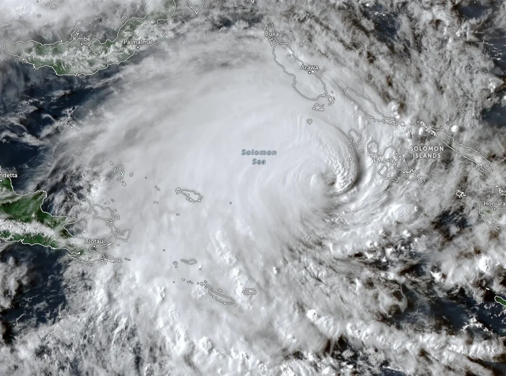
Severe Tropical Cyclone Maila remained over the Solomon Sea at 06:00 UTC on April 8, 2026, with sustained winds of 165 km/h (103 mph) and a central pressure of 941 hPa, while beginning a gradual weakening trend after recent rapid intensification. The system is moving slowly northward at 6 km/h (3.7 mph) and is forecast to track west to southwest toward southeastern Papua New Guinea before entering the Coral Sea later this week.
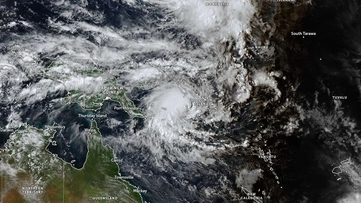
Satellite image of Tropical Cyclone Maila at 06:10 UTC on April 8, 2026. Credit: JMA/Himawari-9, Zoom Earth, The Watchers
At 06:00 UTC on April 8, the center of Severe Tropical Cyclone Maila was located about 465 km (290 miles) west of Honiara and 960 km (595 miles) east of Port Moresby.
The system had sustained winds of 165 km/h (103 mph) and a central pressure of 941 hPa, according to a tropical cyclone technical bulletin issued at 07:06 UTC by the Australian Bureau of Meteorology (BOM). The system has weakened over recent hours following a period of rapid intensification, while maintaining a well-defined but increasingly ragged eye structure.
Satellite analysis shows the eastern semicircle of the cyclone weakening due to dry air entrainment and moderate easterly vertical wind shear estimated at 18-28 km/h (11-17 mph). Convection remains deeper on the western side of the circulation, resulting in an asymmetric structure.
Environmental conditions remain otherwise favorable, with sea surface temperatures near 29-30°C (84-86°F) and moderate upper-level outflow.
The system is moving slowly northward at approximately 6 km/h (3.7 mph), with weak steering currents dominating the near-term motion.
This slow movement is increasing the likelihood of ocean upwelling beneath the cyclone, a process that brings cooler subsurface water to the surface and reduces the available energy for maintaining intensity. Upwelling is assessed as a primary driver of the current weakening trend during the next 24 to 36 hours.
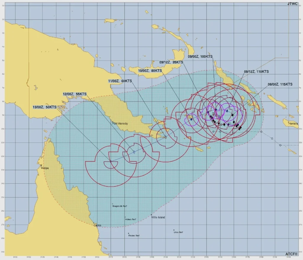
Forecast guidance indicates that a mid-level ridge building to the southwest will become the dominant steering mechanism, turning the system toward the west and southwest.
This track brings Severe Tropical Cyclone Maila toward southeastern Papua New Guinea, with the forecast corridor passing close to or across the Louisiade Archipelago around April 10, although the exact track and timing remain uncertain due to low forecast confidence.
The Louisiade Archipelago lies within the current forecast track envelope and within the cyclone’s broader wind field, where gale-force winds extend up to approximately 185-220 km (115-137 miles) from the center. Even without a direct passage of the cyclone center, the region is likely to experience prolonged periods of strong winds, heavy rainfall, and hazardous marine conditions.
A hurricane-force wind warning remains in effect for the surrounding marine area, with sustained winds near the center reaching 165 km/h (103 mph) and gusts potentially exceeding these values by up to 40 percent in squalls.
Significant wave heights are estimated near 9.8 m (32 feet), with maximum waves potentially reaching twice that height under extreme conditions, producing phenomenal seas near the cyclone core.
After interacting with southeastern Papua New Guinea, the system is forecast to enter the Coral Sea over the weekend and continue generally southwestward.
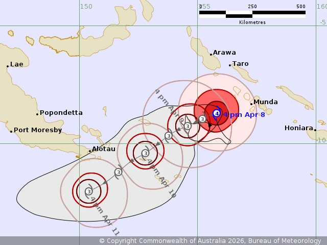
Forecast track maps suggest a possible approach toward the coast of Queensland early next week, with the most likely crossing currently near the Cape York Peninsula, although model guidance shows considerable spread in both track and timing.
Deterministic model guidance remains in poor agreement, with some solutions indicating a faster southwestward motion toward Queensland, while others suggest the system could remain quasi-stationary for a longer period in the Solomon Sea. This divergence results in low confidence for both track and intensity forecasts beyond 48 to 72 hours.
Intensity guidance from multiple agencies indicates a continued weakening trend, initially driven by ocean upwelling and later by increasing vertical wind shear and dry air entrainment. Some mesoscale models suggest a more rapid weakening during the next 24 hours, although this scenario remains uncertain.
The forward speed of the cyclone is expected to increase after approximately 36 hours as steering currents strengthen, reducing the upwelling effect but increasing the potential for a more direct southwestward trajectory toward northern Australia.
According to BOM, Maila may cross the Cape York Peninsula early next week.
References:
1 Tropical Cyclone Technical Bulletin for Severe Tropical Cyclone Maila – BOM – Issued 07:06 UTC on April 8, 2026
2 Ocean Wind Warning for Metarea 10 Northeast – BOM – Issued 07:12 UTC on April 8, 2026
3 Tropical Cyclone Forecast Track Map – BOM – Issued 06:25 UTC on April 8, 2026
4 Prognostic Reasoning for Tropical Cyclone 30P (Maila) – JTWC – Issued 03:00 UTC on April 8, 2026
I'm a dedicated researcher, journalist, and editor at The Watchers. With over 20 years of experience in the media industry, I specialize in hard science news, focusing on extreme weather, seismic and volcanic activity, space weather, and astronomy, including near-Earth objects and planetary defense strategies. You can reach me at teo /at/ watchers.news.
Commenting rules and guidelines
We value the thoughts and opinions of our readers and welcome healthy discussions on our website. In order to maintain a respectful and positive community, we ask that all commenters follow these rules.