
Rapidly intensifying Tropical Cyclone Maila stalls in the Solomon Sea
A rapidly intensifying Tropical Cyclone Maila remained nearly stationary in the Solomon Sea on April 5, 2026, as competing atmospheric ridges limited its movement. Forecasts indicate continued strengthening in the short term, followed by potential weakening due to ocean cooling. The system may move closer to the north Queensland coast later in the week.

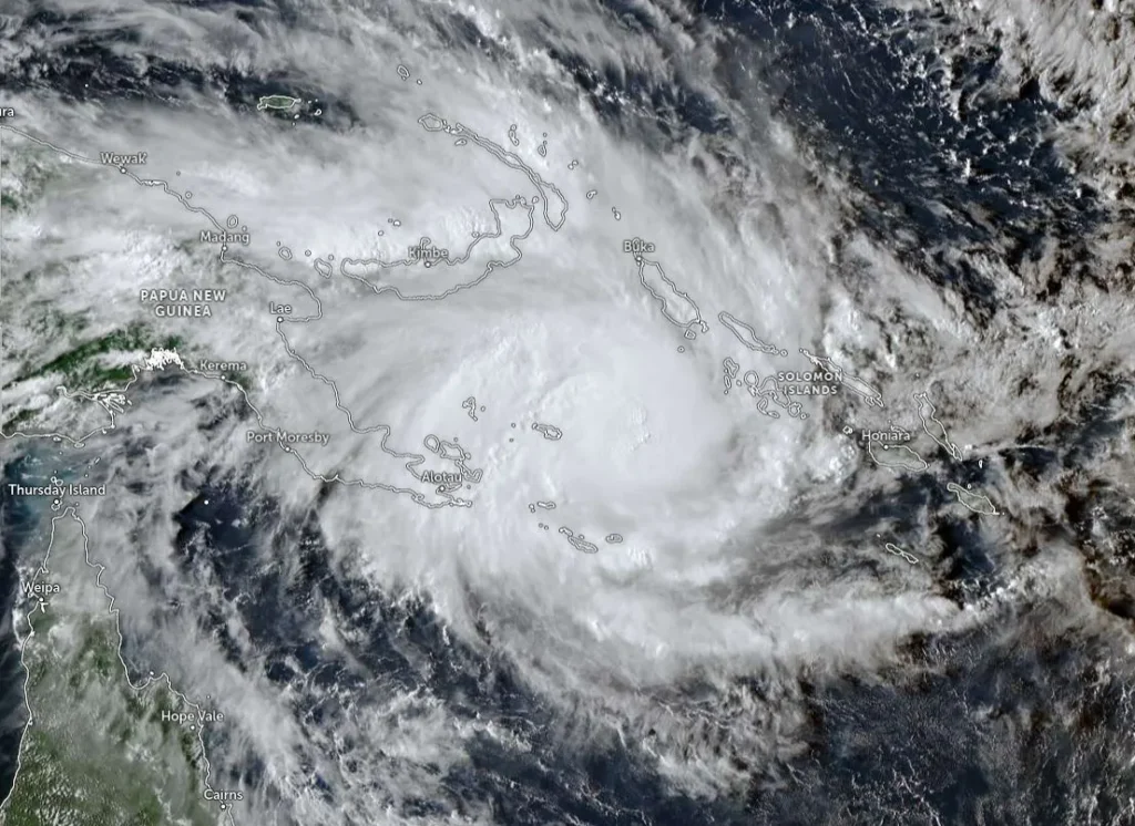
Tropical Cyclone Maila at 06:00 UTC on April 5, 2026. Credit: JMA/Himawari-9, Zoom Earth, The Watchers
Tropical Cyclone Maila intensified to approximately 120 km/h (75 mph) as of 03:00 UTC on April 5, about 1 280 km (795 miles) northeast of Cairns, Australia, in the Solomon Sea.
The system has remained nearly stationary, moving west-northwestward at about 4 km/h (2.5 mph), under the influence of competing steering mechanisms to the north and south.
Maila is embedded in a highly favorable environment characterized by low vertical wind shear of 10–15 knots, sea surface temperatures of 29–30°C (84–86°F), and strong radial outflow aloft.
Satellite analysis shows deep convection concentrated near the center with defined banding, while scatterometer and SAR data indicate sustained winds in the 100–130 km/h (62–81 mph) range across much of the inner core.
Forecast guidance suggests continued strengthening over the next 24–36 hours, with peak intensity expected to reach approximately 205 km/h (127 mph). Multiple rapid intensification indicators have been triggered, and recent observations suggest the system has already intensified faster than earlier forecasts indicated.
Steering conditions remain weak and complex, with the cyclone positioned between a subtropical ridge over Australia and a near-equatorial ridge to the north. This configuration is expected to produce slow and potentially erratic motion, including the possibility of a counterclockwise loop through the next several days.
Numerical model guidance is in relatively good agreement through 48 hours, suggesting limited movement and looping behavior.
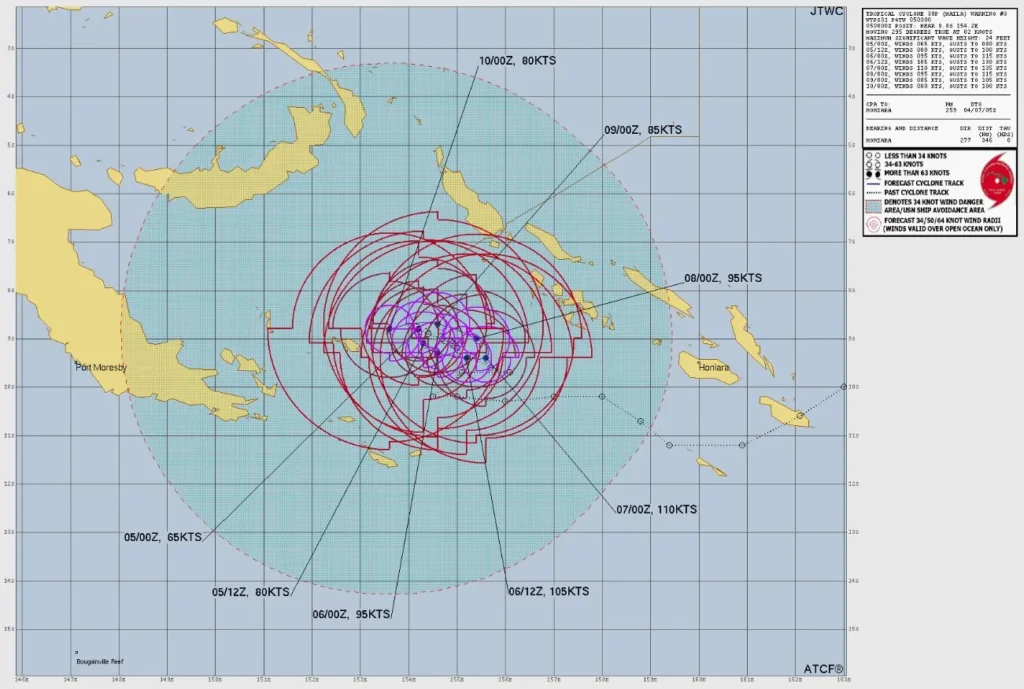
Some models, including GFS, suggest a westward track toward the Coral Sea, while others, including ensemble and AI-based guidance, suggest a more stationary or northward trajectory, resulting in low confidence in the forecast track beyond the short term.
After reaching peak intensity, the system is forecast to weaken as a result of ocean cooling caused by its slow movement. Prolonged residence over the same waters may induce upwelling, reducing available ocean heat content. However, if the system accelerates westward into warmer waters, reintensification remains possible.
No warning or watch zones are currently in effect.
According to the Australian Bureau of Meteorology (BOM), the environment is generally favorable for further development, and Maila is forecast to become a severe tropical cyclone tonight or early Monday, April 6.
“The steering influences are balanced, and Maila is expected to be slow-moving over the Solomon Sea through until the middle of the week, when it is forecast to begin moving southwest. This system is not expected to directly impact the Queensland coast before the middle of the week, but may move closer to the north Queensland coast later in the week.”
Maila is the 11th named storm of the 2025-26 Australian region cyclone season.
References:
1 Tropical Cyclone 30P (Maila) Warning #03 – JTWC – Issued at 03:00 UTC on April 5, 2026
2 Tropical Cyclone Maila Technical Bulletin – BOM – Issued at 06:00 UTC on April 5, 2026
I'm a dedicated researcher, journalist, and editor at The Watchers. With over 20 years of experience in the media industry, I specialize in hard science news, focusing on extreme weather, seismic and volcanic activity, space weather, and astronomy, including near-Earth objects and planetary defense strategies. You can reach me at teo /at/ watchers.news.
Commenting rules and guidelines
We value the thoughts and opinions of our readers and welcome healthy discussions on our website. In order to maintain a respectful and positive community, we ask that all commenters follow these rules.