
Severe Tropical Cyclone Narelle to pass close to the North West Cape, bringing destructive winds to Western Australia
Severe Tropical Cyclone Narelle strengthened to Category 4 off the coast of Western Australia on March 26, 2026, and was forecast to pass close to the North West Cape before tracking south along the Gascoyne coast on March 27. The Bureau of Meteorology warned the system could bring very destructive wind gusts up to 275 km/h (171 mph), dangerous storm surge, and heavy rainfall capable of producing flash flooding across parts of the Pilbara and Gascoyne.

Satellite image of Tropical Cyclone Narelle at 10:10 UTC on March 26, 2026. Credit: JMA/Himawari-9, Zoom Earth, The Watchers
As of 19:00 AWST (11:00 UTC), the system was located within 20 km (12 miles) of 20.2°S 114.9°E, or about 215 km (134 miles) west-northwest of Karratha and 210 km (130 miles) north-northeast of Exmouth.
Narelle was moving southwest at 18 km/h (11 mph), with sustained winds near the centre of 175 km/h (109 mph) and gusts to 250 km/h (155 mph).
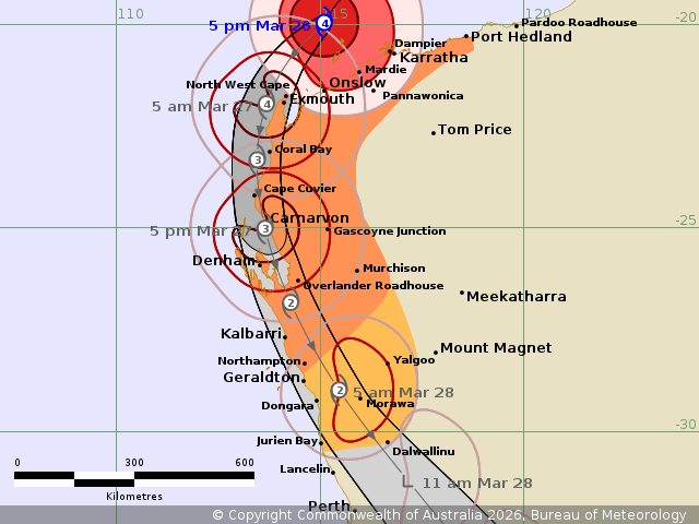
The Bureau of Meteorology has issued a tropical cyclone warning for coastal areas from Whim Creek to Northampton, including Karratha, Onslow, Exmouth, Coral Bay, Carnarvon, and Denham, extending inland to Pannawonica and Murchison. A watch zone remains in effect south to Jurien Bay, including Geraldton, and inland to Yalgoo and Dalwallinu.
Narelle is forecast to strengthen further tonight as it approaches the North West Cape. The cyclone is expected to turn south later tonight or early Friday, likely passing close to the North West Cape as a Category 4 system, with severe impacts extending from the western Pilbara coast to the Gascoyne coast and south to Denham during Friday.
Environmental conditions remain favorable for further intensification, with sea surface temperatures around 29–30°C (84.2–86°F) and strong upper-level outflow supporting convection. A peak intensity near Category 5 remains possible before the system begins to weaken due to increasing wind shear, cooler waters south of Shark Bay, and land interaction.
The cyclone has a broad wind field extending up to approximately 295 km (183 miles), allowing hazardous conditions to affect coastal areas well ahead of the center. Gales are already impacting parts of the Pilbara coast, with observed wind gusts reaching 150 km/h (93 mph) at Bedout Island and 135 km/h (84 mph) at Legendre Island over the past 24 hours.
Very destructive wind gusts up to 275 km/h (171 mph) are forecast to develop between Exmouth and Onslow as the cyclone approaches the North West Cape before extending south along the coast toward Cape Cuvier. Destructive wind gusts of over 125 km/h (78 mph) are forecast across a broader region, including inland areas, with damaging winds potentially extending as far south as Jurien Bay by early March 28.
Heavy to intense rainfall is expected across the western Pilbara and Gascoyne regions, with totals of over 200 mm (8 inches) being forecast, leading to a high risk of flash flooding and potentially severe flash flooding. Rainfall is forecast to extend further south into the South West Land Division, with accumulations of 50–100 mm (2–4 inches) possible over the coming days.
A dangerous storm tide is expected to develop along the Gascoyne coast between Onslow and Denham as the cyclone tracks southward, with sea levels forecast to rise significantly above normal high tide. This may result in damaging waves and coastal flooding, particularly in low-lying areas, while large waves and elevated tides may also produce minor flooding further north along the Pilbara coast.
Narelle is forecast to weaken on Saturday as it moves south-southeast quickly, with impacts extending into the Central West and then further inland and south across the South West Land Division. On Saturday, the strongest winds are expected to be on the eastern side of the system.
Narelle reached Category 5 strength on March 19, before making its first landfall over the Queensland Coast on March 20. It then made a second landfall over the northeastern Northern Territory, north of Numbulwar, during the afternoon hours of March 21.
Rainfall totals of over 200–230 mm (8–9 inches) were reported within 24 hours between March 22 and 23 in some areas, triggering rapid river rises and inundation of low-lying communities.
Severe flooding continues across parts of the Northern Territory, including Katherine, where the Katherine River has been in flood since Narelle crossed the region. A Flood Emergency Warning is in effect on March 26, with major flooding reported at Daly River.
“A flood peak has passed Theyona Station and is approaching Beeboom Crossing. Prolonged major flooding is continuing along the Daly River at Daly River Police Station, where river levels are expected to remain above the major flood level for the remainder of March,” the Northern Territory Emergency Service said.
The Daly River at Daly River Police Station is currently at 14.52 m (47.6 feet) and steady, with major flooding. The river is expected to remain above the major flood level of 14 m (45.9 feet) for the remainder of March, with renewed rises possible as upstream flows arrive.
Further upstream, major flooding is occurring at Katherine Bridge. As these flows move downstream, renewed river level rises are possible along the Daly River over the coming days.
Showers and thunderstorms are forecast across the Daly River catchment over the next few days, but are not expected to significantly contribute to riverine flows.
References:
1 Tropical Cyclone Forecast Track Map – BoM – March 26, 2026
2 Tropical Cyclone Technical Bulletin – BoM – March 26, 2026
3 Tropical Cyclone Advice – BoM – March 26, 2026

I am an Assistant Editor and Severe Weather & Science Journalist at The Watchers, specializing in real-time severe weather coverage, geophysical event reporting, and research-driven scientific analysis. You can reach me at rishav(at)watchers(.)news.
Commenting rules and guidelines
We value the thoughts and opinions of our readers and welcome healthy discussions on our website. In order to maintain a respectful and positive community, we ask that all commenters follow these rules.