
Tropical Cyclone Narelle weakens after Queensland landfall, forecast to re-intensify over Gulf of Carpentaria
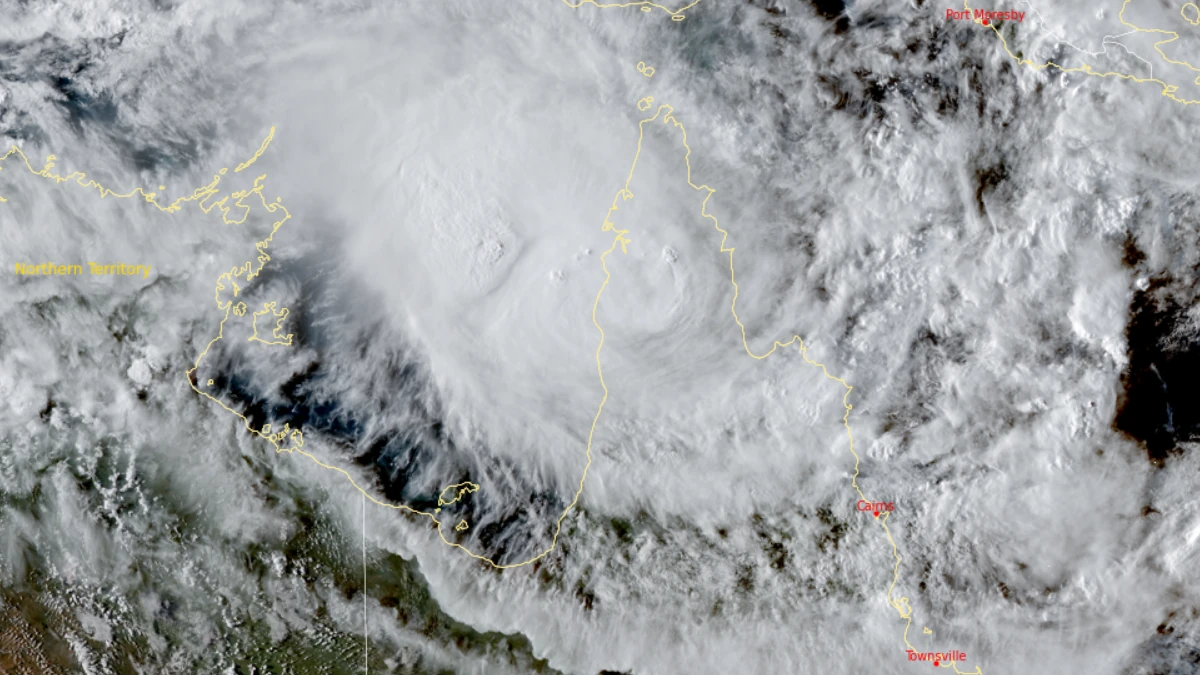
Tropical Cyclone Narelle made landfall over the Queensland coast at 07:00 AEST on March 20, 2026, as a high-end Category 4 system after briefly reaching Category 5 intensity a day earlier. The cyclone crossed the coast approximately 75 km (47 miles) south of Lockhart River, weakened to Category 2 by the afternoon, and began moving offshore toward the Gulf of Carpentaria. Destructive winds, heavy rainfall, and coastal flooding were reported across affected areas.
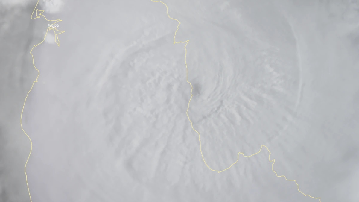
Satellite image of tropical cyclone Narelle's eyewall beginning landfall over the Queensland coast at 07:00 AEST on March 20 (21:00 UTC on March 19), 2026. Credit: JMA/Himawari-9, RAMMB/CIRA, The Watchers
Tropical Cyclone Narelle made landfall over the Queensland coast at around 07:00 AEST on Friday, March 20 (21:00 UTC on Thursday, March 19).
While the system briefly reached Category 5 strength on Thursday, it had weakened to a high-end Category 4 cyclone before making landfall approximately 75 km (47 miles) south of Lockhart River. The system then moved north of Coen and weakened further to Category 3 as it continued inland.
Narelle weakened to a Category 2 system by Friday afternoon and was moving west toward the Gulf of Carpentaria.
Early observed impacts included heavy rainfall across Cape York Peninsula, with 24-hour totals of 360 mm (14.2 inches) at Wenlock River and 348 mm (13.7 inches) at Pascoe River. Wenlock River also recorded more than 120 mm (4.7 inches) since 09:00 AEST on March 20.
The system was located about 55 km (34 miles) east of Aurukun and 630 km (391 miles) east of Alyangula as of 16:00 AEST (06:00 UTC) on Friday. 10-minute maximum sustained winds were 100 km/h (62 mph), with 3-second gusts reaching 140 km/h (87 mph). The system was moving west at 18 km/h (11 mph).
In its 17:42 AEST advice, BoM said Narelle was impacting Aurukun, with a warning in effect for western Cape York Peninsula between Mapoon and Pormpuraaw, including Weipa and Aurukun. The warning for eastern Cape York, including Lockhart River and Coen, had been cancelled as the cyclone shifted westward.
A watch was also in effect farther west across the Northern Territory, extending to Ramingining, Bulman, and Ngukurr, as Narelle was forecast to strengthen again over the Gulf of Carpentaria before approaching the eastern Top End.
Narelle was expected to continue moving west into the Gulf of Carpentaria on Friday night, where BoM said it could re-intensify into a severe tropical cyclone before impacting the eastern Northern Territory from late Saturday.
The system is then forecast to move across the Top End and may move offshore of the Kimberley coast early next week, where BoM indicated a high risk of redevelopment into a tropical cyclone.
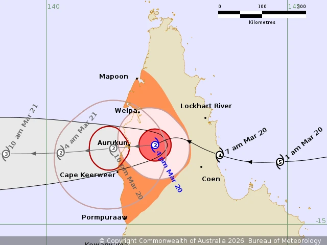
In Queensland, destructive wind gusts of up to 150 km/h (93 mph) are forecast near the center, including the Aurukun area, through Saturday evening. Gales with damaging wind gusts to 120 km/h (75 mph) are likely between Weipa and Cape Keerweer as Narelle moves into the Gulf of Carpentaria this afternoon and evening.
Damaging gusts may extend to coastal areas between Mapoon and Pormpuraaw later tonight, depending on the movement and development of Narelle in the Gulf.
Heavy rainfall that may lead to flash flooding, including locally intense falls, is likely over the western half of Cape York Peninsula, including Pormpuraaw and Mapoon, today.
Once Narelle moves into the Gulf of Carpentaria, tides along the western peninsula between Weipa and Kowanyama may be higher than normal. Large waves may produce minor flooding of low-lying coastal areas.
Very destructive wind gusts of up to 195 km/h (121 mph) are forecast to develop in coastal areas between Birany Birany and Numbulwar, including Groote Eylandt, late Saturday afternoon and overnight into Sunday as Narelle approaches from the east.
Destructive wind gusts to 160 km/h (100 mph) are possible from south of Nhulunbuy to Nathan River on Saturday night or Sunday morning, depending on the system’s movement. Gales with damaging wind gusts to 120 km/h (75 mph) are forecast for coastal and adjacent inland areas between Gapuwiyak and Port McArthur, including Nhulunbuy and Borroloola, from Saturday afternoon through overnight into Sunday.
These gales may extend west to Ramingining, Bulman, and Ngukurr on Sunday.
Heavy rainfall, which may lead to flash flooding, is likely to develop over coastal and adjacent inland areas across the eastern Top End between Port McArthur and south of Nhulunbuy from Saturday afternoon and evening.
Locally intense rainfall leading to dangerous and life-threatening flash flooding is likely over the eastern Top End between Numbulwar and Birany Birany, including Groote Eylandt, from Saturday afternoon and evening.
Tides will be higher than normal between Nhulunbuy and Port McArthur later Saturday and Sunday. Large waves may produce minor flooding of low-lying coastal areas.
A potentially dangerous storm tide is possible between Alyangula and Port Roper as the cyclone center crosses the coast, with damaging waves and dangerous flooding.
References:
1 Tropical Cyclone Forecast Track Map – BoM – March 20, 2026
2 Tropical Cyclone Technical Bulletin – BoM – March 20, 2026
3 Tropical Cyclone Advice – BoM – March 20, 2026

I am an Assistant Editor and Severe Weather & Science Journalist at The Watchers, specializing in real-time severe weather coverage, geophysical event reporting, and research-driven scientific analysis. You can reach me at rishav(at)watchers(.)news.
Commenting rules and guidelines
We value the thoughts and opinions of our readers and welcome healthy discussions on our website. In order to maintain a respectful and positive community, we ask that all commenters follow these rules.