
Tropical Cyclone Narelle strengthens off Western Australia, Category 4 intensity forecast near the coast
Severe Tropical Cyclone Narelle re-intensified, reaching Category 3 strength off the coast of Western Australia on March 25, 2026, and is forecast to strengthen further while tracking parallel to the Pilbara coast. The system reached Category 3 intensity with sustained winds of 130 km/h (81 mph), with forecasts indicating strengthening to Category 4 as it approaches the North West Cape late March 26.
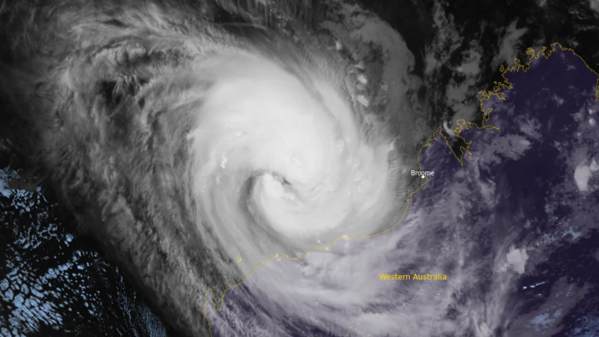
Satellite image of Tropical Cyclone Narelle at 16:40 UTC on March 25, 2026. Credit: JMA/Himawari-9, RAMMB/CIRA, The Watchers
Severe Tropical Cyclone Narelle re-intensified over the eastern Indian Ocean off Western Australia, reaching Category 3 strength on March 25. As of 23:00 AWST (15:00 UTC), Narelle was located around 260 km (162 miles) north-northwest of Port Hedland and 290 km (180 miles) north-northeast of Karratha.
10-minute maximum sustained winds near the center reached 130 km/h (81 mph), with 3-second gusts reaching up to 185 km/h (115 mph). The system was moving west-southwest at 20 km/h (12 mph). The estimated minimum central pressure at 20:00 AWST (12:00 UTC) on March 25 was 974 hPa.
The cyclone has shown renewed organization, supported by favorable environmental conditions, including sea surface temperatures of 29–30°C (84–85°F), low vertical wind shear, and strong upper-level outflow.
These factors are expected to support rapid intensification over the next 24–36 hours, with forecasts indicating strengthening to Category 4 intensity, with sustained winds of 195 km/h (121 mph). A peak intensity equivalent to Category 5 remains possible.
Narelle is currently tracking roughly parallel to the Pilbara coastline and is forecast to continue on a west-southwest trajectory before turning south late March 26 under the influence of a mid-level trough.
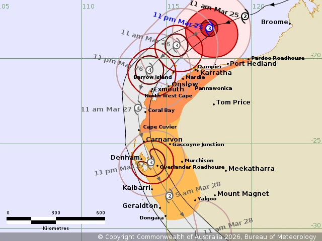
The system is expected to pass close to the North West Cape as a severe tropical cyclone, then continue south along the west coast of Western Australia through March 27.
Impacts are forecast to begin along the Pilbara coast late March 26, extending south into the Gascoyne and Central West regions during March 27, before Narelle moves inland across the South West Land Division.
A tropical cyclone warning is in effect for coastal areas from Pardoo Roadhouse to Cape Cuvier, including Port Hedland, Karratha, Onslow, Exmouth, and Coral Bay, extending inland to Pannawonica. A watch zone extends further south from Cape Cuvier to Dongara, including Carnarvon, Denham, and Geraldton.
Very destructive wind gusts up to 260 km/h (162 mph) may develop west of Onslow late March 26 as the cyclone approaches the North West Cape, with destructive winds in excess of 125 km/h (78 mph) expected along parts of the Pilbara and Gascoyne coasts. Gale-force winds are forecast to extend over a broad area due to the cyclone’s large size, impacting coastal communities well before the center approaches.
A dangerous storm tide is expected between Onslow and Denham as the cyclone tracks southward along the coast, with water levels likely to rise significantly above normal high tide levels. This may result in coastal inundation, damaging waves, and flooding of low-lying areas. Elevated tides and large waves are also forecast between Port Hedland and Onslow, with minor flooding possible in exposed coastal zones.
Forecast data indicate that Narelle could begin weakening as it moves south of Shark Bay, where sea surface temperatures drop below 26°C (78°F) and wind shear increases. The system is expected to weaken further after land interaction and transition into a mid-latitude system by March 29, 2026, as it moves into the Southern Ocean.
Narelle had reached Category 5 strength earlier on March 19, before making landfall over the Queensland Coast on March 20. It then made a second landfall over the northeastern Northern Territory, north of Numbulwar during the afternoon hours of March 21.
Rainfall totals of over 200–230 mm (8–9 inches) were reported within 24 hours between March 22 and 23 in some areas, triggering rapid river rises and inundation of low-lying communities.
References:
1 Tropical Cyclone Forecast Track Map – BoM – March 25, 2026
2 Tropical Cyclone Technical Bulletin – BoM – March 25, 2026
3 Tropical Cyclone Advice – BoM – March 25, 2026

I am an Assistant Editor and Severe Weather & Science Journalist at The Watchers, specializing in real-time severe weather coverage, geophysical event reporting, and research-driven scientific analysis. You can reach me at rishav(at)watchers(.)news.
Commenting rules and guidelines
We value the thoughts and opinions of our readers and welcome healthy discussions on our website. In order to maintain a respectful and positive community, we ask that all commenters follow these rules.