
Heavy rainfall and flooding impact Northern Territory as ex-Tropical Cyclone Narelle moves west
Heavy rainfall from ex-Tropical Cyclone Narelle triggered flooding across parts of the Northern Territory, Australia, between March 21 and 23, 2026, inundating properties, disrupting infrastructure, and prompting evacuations. As of March 23, the system was moving west across the Kimberley and had a high chance of redeveloping into a tropical cyclone over waters off Western Australia by March 25, with further strengthening forecast. Severe weather was expected to continue across northern Kimberley through March 24.
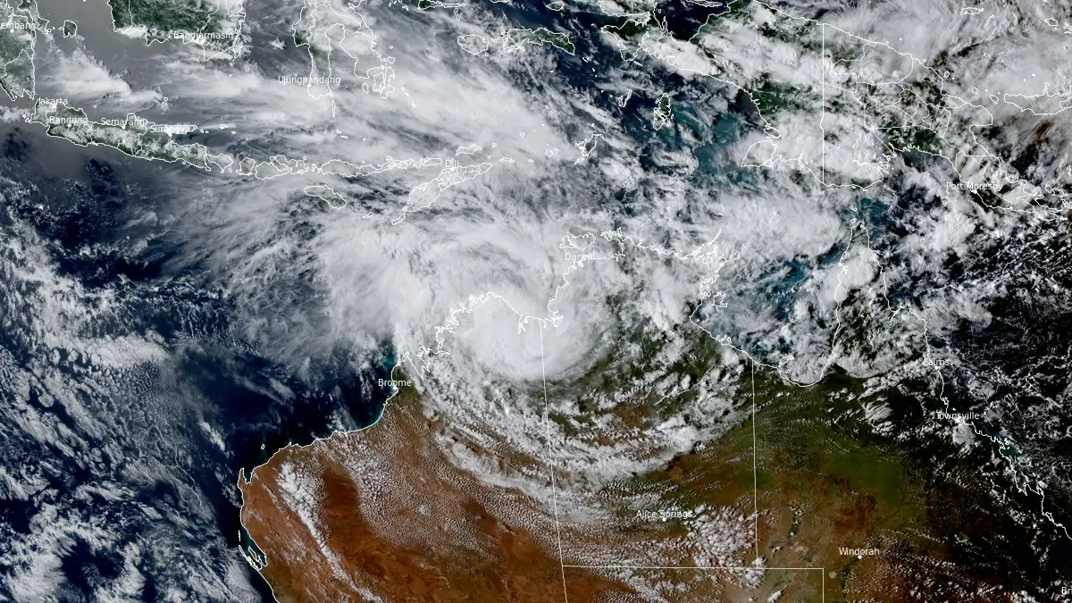
Satellite image of Ex-Tropical Cyclone Narelle at 07:20 UTC on March 23, 2026. Credit: JMA/Himawari-9, RAMMB/CIRA, The Watchers
Tropical Cyclone Narelle made its second landfall over the northeastern Northern Territory, north of Numbulwar, during the afternoon hours of March 21, with 10-minute maximum sustained winds reaching 148 km/h (92 mph).
After moving inland, the circulation weakened while producing widespread heavy rainfall across the Top End, leading to significant flooding in multiple river catchments.
Rainfall totals of over 200–230 mm (8–9 inches) were reported within 24 hours between March 22 and 23 in some areas, triggering rapid river rises and inundation of low-lying communities.
Meanwhile, the Darwin area reported around 60 mm (2.3 inches) of rain during the same period. Severe weather is forecast to continue across northern Kimberly through March 23 and 24, with 24-hour rainfall totals of up to 140 mm (5.5 inches) being forecast. Wind gusts of up to 100 km/h (62 mph) will also be possible during this period.
River levels rose sharply across several basins, with media sources reporting the Adelaide River reaching approximately 12.6 m (41 feet), exceeding major flood levels and inundating nearby properties. Flooding was also reported along the Katherine, Daly, and Waterhouse river systems, with authorities maintaining flood warnings as water levels continued to respond to upstream rainfall.
Emergency services conducted evacuations and rescues in affected communities, with around 500 people being displaced due to the cyclone’s impacts. Floodwaters caused road closures, including disruptions along key transport routes, and led to power outages and water supply issues in several locations.
While severe weather has eased over the Top End, cleanup continues in multiple areas, including parts of North Queensland, after Narelle swept over the Cape York Peninsula, narrowly missing populated communities on March 20. Wind gusts up to 109 km/h (67 mph) were reported in Weipa, along with rainfall totals of 217 mm (8.5 inches) overnight on March 20 into 21. Up to 400 mm (16 inches) of rainfall was reported in some areas during the same period.
Queensland Premier David Crisafulli said the tropical cyclone left the east coast of Cape York, just south of Aurukun, overnight, delivering “sizeable winds and some pretty reasonable rain” despite being downgraded to a category 2 system.
As of 20:00 AWST (12:00 UTC) on March 23, the low-pressure system was located over the north Kimberley region of Western Australia, with sustained winds near the center of 55 km/h (34 mph) and gusts to 85 km/h (53 mph), according to the Bureau of Meteorology.
Despite weakening, the system continues to produce heavy rainfall across the Kimberley, with the Bureau warning that ongoing precipitation may lead to flash flooding, particularly across northern parts of the region. Severe Weather Warnings remain in place for heavy rainfall and damaging wind gusts.
Gales with damaging wind gusts up to 90 km/h (56 mph) are expected along coastal areas between Kuri Bay and Beagle Bay, while stronger gusts up to 100 km/h (62 mph) may develop further south between Wallal Downs and Port Hedland as the circulation moves offshore.
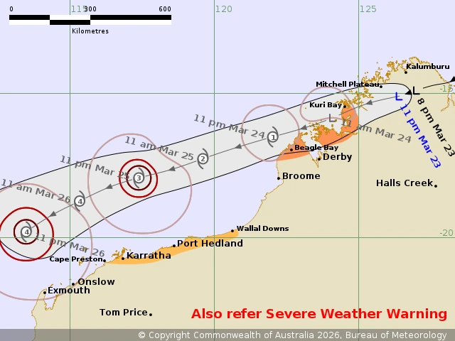
The system is forecast to move off the northwest Kimberley coast during March 24 and track west-southwest parallel to the Pilbara coastline. Environmental conditions over warm offshore waters are favorable for redevelopment. There is a high probability that the system will regain tropical cyclone intensity by early March 25.
The Bureau of Meteorology forecasts further strengthening, with the system expected to reach severe tropical cyclone intensity (Category 3 or higher) by March 25–26 while remaining offshore.
While the circulation is expected to remain offshore during its strengthening phase, gales may extend along the Pilbara coast, bringing damaging winds, heavy rainfall, and potential coastal impacts, including elevated sea levels and storm surge.
Forecast uncertainty remains regarding the exact track beyond March 26, particularly concerning any southward movement toward more populated coastal regions of Western Australia.
References:
1 Tropical Cyclone Advice – BoM– March 23, 2026.
2 Tropical Cyclone Forecast Track Map – BoM– March 23, 2026.
3 ECHO Daily Flash – ERCC – March 23, 2026
4 ‘A real blessing’: Clean-up under way after Tropical Cyclone Narelle crosses Cape York Peninsula – 9 News – March 21, 2026

I am an Assistant Editor and Severe Weather & Science Journalist at The Watchers, specializing in real-time severe weather coverage, geophysical event reporting, and research-driven scientific analysis. You can reach me at rishav(at)watchers(.)news.
Commenting rules and guidelines
We value the thoughts and opinions of our readers and welcome healthy discussions on our website. In order to maintain a respectful and positive community, we ask that all commenters follow these rules.