
Red Flag Warnings issued for parts of Wyoming, Nebraska, and South Dakota
Red Flag Warnings were in effect across parts of Wyoming, Nebraska, and South Dakota on March 25, 2026, as strong winds, very low humidity, and unseasonably warm temperatures created conditions favorable for rapid wildfire spread. Additional fire weather warnings were also issued in parts of nearby states, while some warnings in Nebraska and Wyoming extended into March 26.
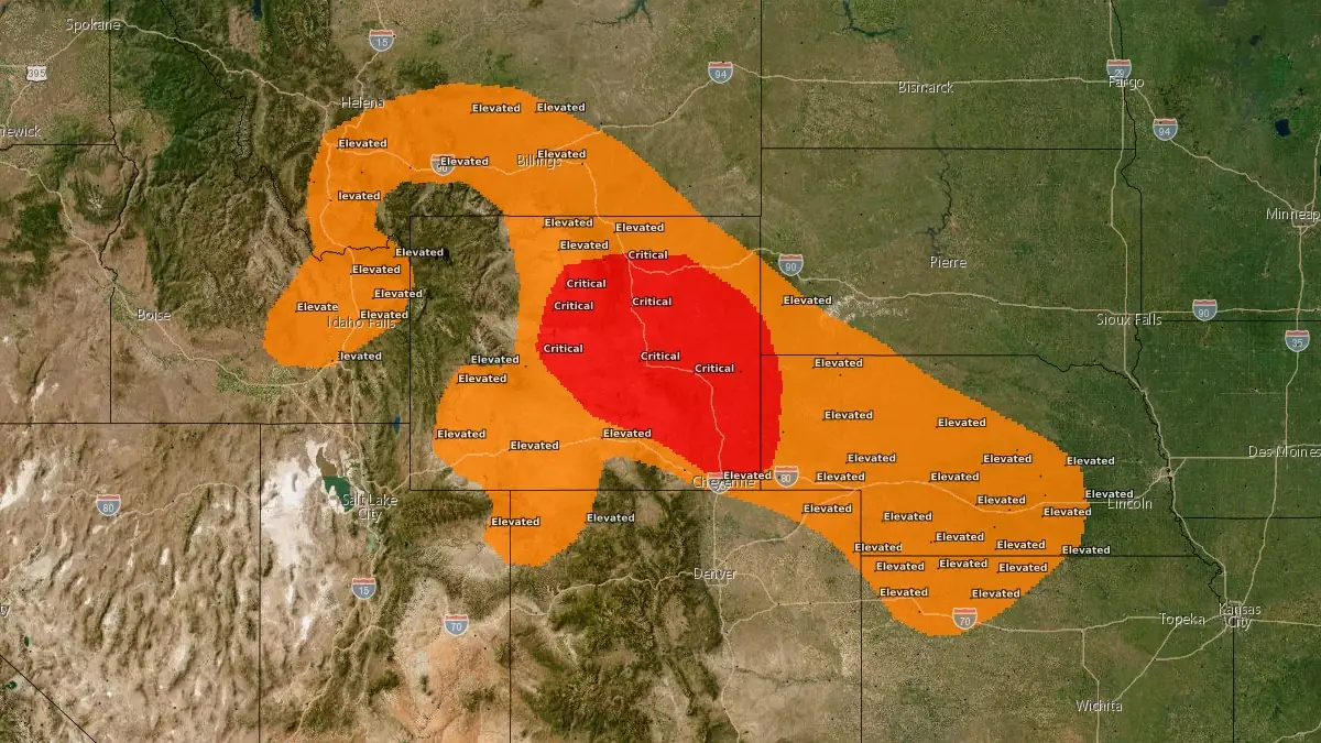
Critical fire weather - March 25, 2026. Credit: NWS
Red Flag Warnings are in effect across parts of the central High Plains and adjacent Rocky Mountain region on March 25, 2026, as meteorological conditions support critical fire weather across portions of Wyoming, Nebraska, South Dakota, and nearby areas.
The National Weather Service (NWS) offices in Cheyenne, Riverton, North Platte, Rapid City, Billings, Missoula, Grand Junction, and Hastings issued multiple coordinated warnings covering numerous fire weather zones, with the most widespread period of concern from late morning through the evening hours. In several areas of Nebraska and Wyoming, warnings extend into March 26.
Sustained west to southwest winds of 25–65 km/h (15–40 mph), with gusts reaching 65–95 km/h (40–60 mph), are forecast across much of the region. The strongest winds are expected in parts of Wyoming and Montana, including mountainous and foothill areas, where gusts may locally reach 95 km/h (60 mph).
Relative humidity values are forecast to drop to between 10–20% during peak heating, with some locations reporting minimum values near 10–12%.
Temperatures are expected to rise well above seasonal averages, with highs reaching the upper 20s to low 30s °C (upper 70s to lower 90s °F) across parts of Nebraska, Wyoming, and surrounding regions. This combination of warm temperatures and dry fuels significantly enhances the potential for ignition and rapid fire spread.
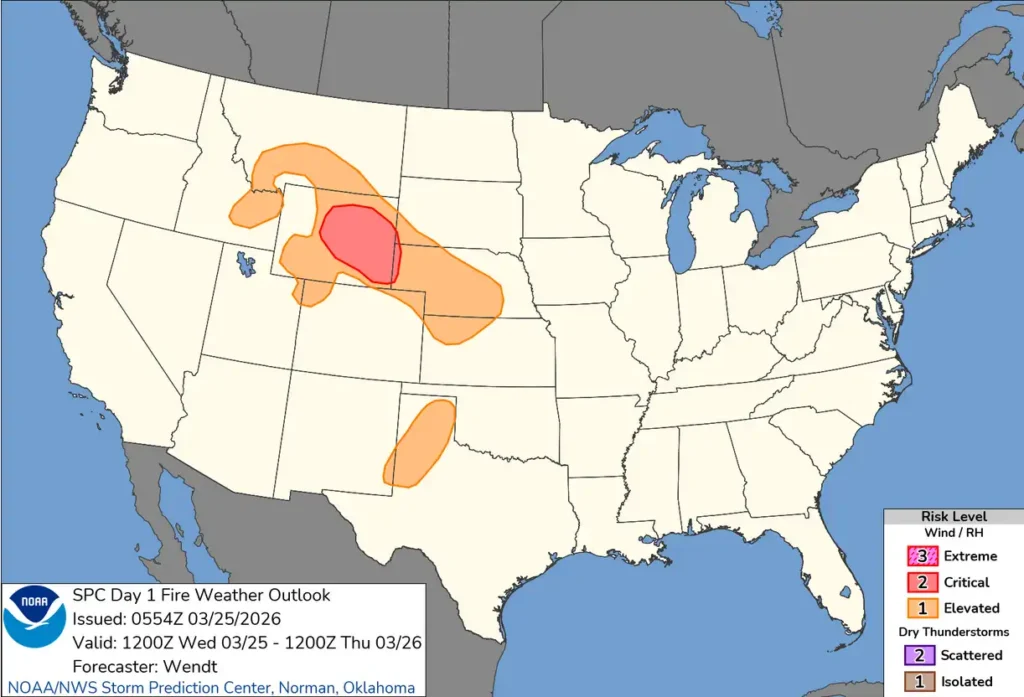
The Storm Prediction Center (SPC) identified a Critical Fire Weather area in its Day 1 Fire Weather Outlook for parts of central and eastern Wyoming into far western Nebraska and extreme southwest South Dakota, citing a strengthening surface pressure gradient and strong mid-level winds contributing to sustained surface winds of approximately 30–40 km/h (20–25 mph) and relative humidity near 15%.
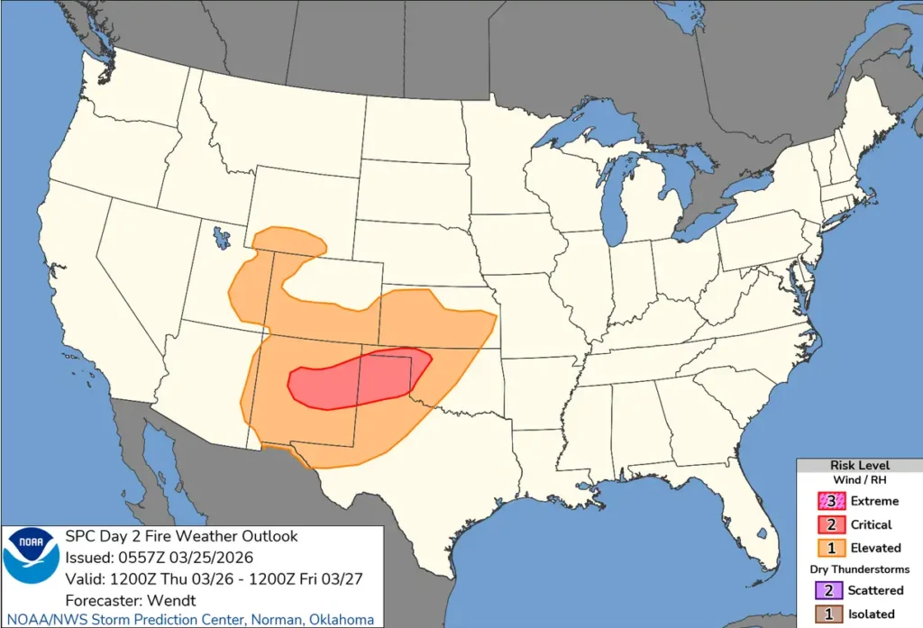
The fire weather threat is forecast to shift southward in the coming days. The SPC Day 2 outlook highlights critical fire weather conditions across central New Mexico into the Texas and Oklahoma Panhandles and northwest Oklahoma, where low relative humidity and strengthening winds are expected to persist.
Additional hazards include the potential for isolated dry lightning, particularly across portions of western Nebraska and surrounding areas during the late afternoon and evening. Any lightning strikes in dry fuels may act as ignition sources, while associated outflow winds could lead to erratic fire behavior.
A cold front is forecast to move through the region late on March 25 into early March 26, bringing an abrupt wind shift from westerly to northerly directions with continued gusts of 30–70 km/h (20–45 mph). While cooler temperatures and slightly higher humidity may follow the frontal passage, the wind shift could exacerbate fire behavior in ongoing incidents.
Late March marks the beginning of the peak fire weather season across the central High Plains and adjacent regions, when dormant grasses and dry vegetation are highly receptive to ignition. Combined with frequent strong wind events and low humidity, this seasonal pattern increases the likelihood of fast-moving grassland fires.
Authorities advise against outdoor burning during the warning period, as even small ignition sources may lead to rapidly spreading fires under the prevailing conditions.
References:
1 Mar 25, 2026 Day 2 Fire Weather Outlook – NWS – March 25, 2026
2 Mar 25, 2026 Day 1 Fire Weather Outlook – NWS – March 25, 2026
3 Day 3-8 Fire Weather Outlook Issued on Mar 24, 2026 – NWS – March 24, 2026

I’m a science journalist and researcher at The Watchers, contributing to the Epicenter edition, where I cover peer-reviewed scientific research and emerging discoveries across Earth and space sciences. With a background in astronomy and a passion for environmental science, I’ve worked in shark and coral conservation in Fiji, conducting reef and shark-behavior research, contributing to mangrove restoration, and earning PADI Open Water and Coral Reef Certifications. I bring a blend of scientific rigor and storytelling to illuminate the discoveries shaping our planet and beyond.
Commenting rules and guidelines
We value the thoughts and opinions of our readers and welcome healthy discussions on our website. In order to maintain a respectful and positive community, we ask that all commenters follow these rules.