
Subtropical low triggers Red Heavy Rain Warning in Northland, New Zealand
A deep subtropical low prompted a Red Heavy Rain Warning for parts of Northland, New Zealand, on March 25, 2026, with 230–280 mm (9–11 inches) of rain forecast for areas east of Kaikohe from Doubtless Bay to Whangārei through early March 27. MetService and local authorities warned of dangerous river conditions, significant flooding and slips, with some communities at risk of isolation.
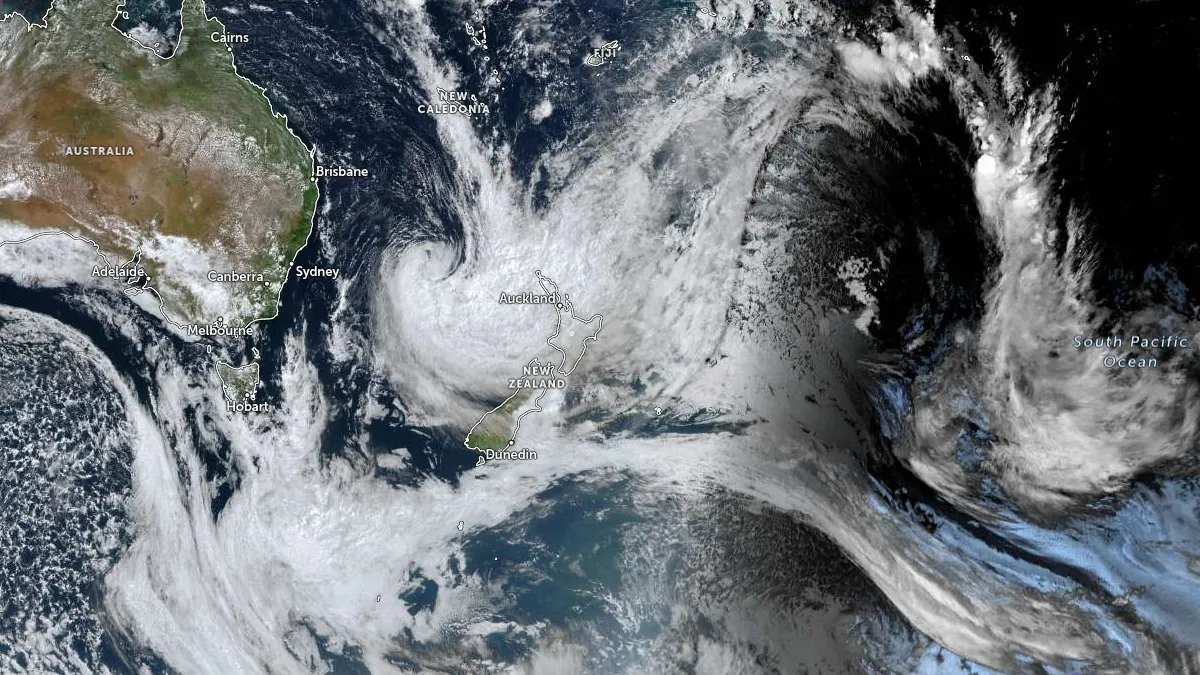
Satellite image acquired at 03:50 UTC on March 25, 2026. Credit: JMA/Himawari-9, Zoom Earth, The Watchers
Heavy rainfall associated with a deep subtropical low prompted a Red Heavy Rain Warning for Northland, New Zealand, beginning at 20:00 LT on March 25, 2026, with 230–280 mm (9–11 inches) forecast through early March 27. MetService warned of dangerous river conditions, significant flooding and slips, with some roads expected to become impassable and some communities potentially isolated.
A Red Heavy Rain Warning is in effect for Northland east of Kaikohe, from Doubtless Bay to Whangārei, for 32 hours from 20:00 LT on March 25 to 04:00 LT on March 27.
Peak rainfall rates will initially reach 15–25 mm (0.6–1 inch) per hour, according to MetService, increasing to 25–40 mm (1–1.6 inches) per hour and possibly higher from Thursday afternoon through early Friday morning. Thunderstorms are also possible from Thursday afternoon.
MetService said the rainfall poses a threat to life from dangerous river conditions, significant flooding and slips. Conditions are expected to disrupt travel, make some roads impassable, and isolate communities. Authorities also warned residents to avoid floodwaters and unnecessary travel, and to be prepared for power and communications outages.
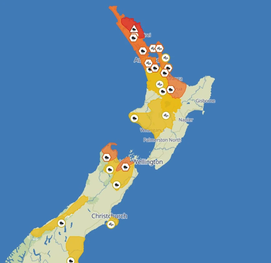
The remainder of Northland is under an Orange Heavy Rain Warning for the same 32-hour period. Forecast rainfall totals there are 120–220 mm (5–9 inches), with peak rates initially at 15–25 mm (0.6–1 inch) per hour, increasing to 25–40 mm (1–1.6 inches) per hour and possibly higher from Thursday afternoon through early Friday morning. Thunderstorms are also possible and there is a high chance the warning could be upgraded to red.
Additional Orange Heavy Rain Warnings are in effect for Great Barrier Island, Auckland, from Whangaparāoa northwards, the Coromandel Peninsula, and the Hunua Range. Great Barrier Island is forecast to receive 150–200 mm (6–8 inches) over 30 hours from 03:00 LT on March 26 to 09:00 LT on March 27, while Auckland, north of Whangaparāoa, is forecast to receive 120–170 mm (5–7 inches) over the same period.
The Coromandel Peninsula is forecast to receive 150–200 mm (6–8 inches) over 36 hours from 06:00 LT on March 26 to 18:00 LT on March 27, with up to 280 mm (11 inches) possible about the Coromandel Range. The Hunua Range is forecast to receive 125–175 mm (5–7 inches) over 33 hours from 03:00 LT on March 26 to 12:00 LT on March 27. The Coromandel warning has a high chance of being upgraded to red.
Northland is under an Orange Strong Wind Warning for 26 hours from 21:00 LT on March 25 to 23:00 LT on March 26, with east to northeast winds gusting up to 120 km/h (75 mph) in exposed places.
Auckland and Great Barrier Island are under a separate Orange Strong Wind Warning for 17 hours from 08:00 LT on March 26 to 01:00 LT on March 27, also with gusts up to 120 km/h (75 mph) in exposed places.
Strong winds associated with this storm may damage trees, powerlines, and unsecured structures, while making travel difficult, especially for high-sided vehicles and motorcycles. Residents were advised to secure loose outdoor items and drive cautiously.
A Heavy Rain Watch is also in effect for Auckland south of Whangaparāoa, excluding the Hunua Range, for 33 hours from 03:00 LT on March 26 to 12:00 LT on March 27. Rainfall amounts in this area may exceed warning criteria and noted a high chance of the watch being upgraded to a warning.
A Strong Wind Watch is also in place for the Coromandel Peninsula and Waikato from 09:00 LT on March 26 to 08:00 LT on March 27, with east to northeast winds that may approach severe gale strength in exposed places.
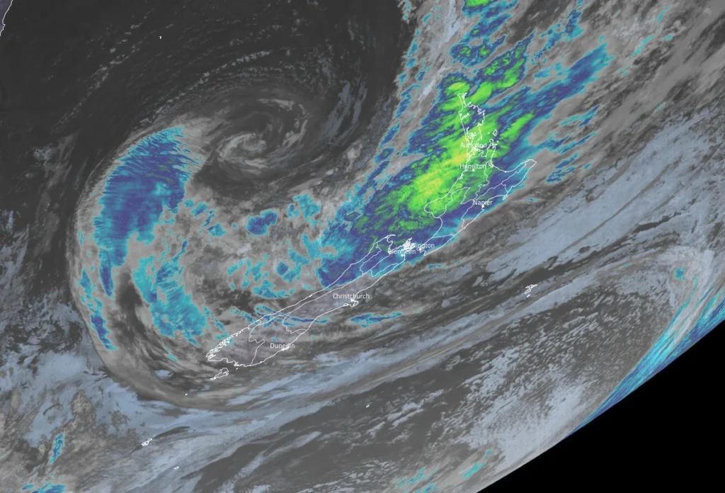
The severe weather event is being driven by a deep subtropical low west of New Zealand, directing warm, moisture-laden air over the upper North Island.
Authorities advised residents not to walk, drive, or swim through floodwaters, to avoid unnecessary travel, and to self-evacuate quickly if rising water is observed.
References:
1 Warnings & Watches – MetService – Accessed March 25, 2026
2 Heavy rain warnings for Northland Te Tai Tokerau – Health New Zealand – March 25, 2026
3 Red rain warning issued for east coast of Far North – FNDC – March 25, 2026

I’m a science journalist and researcher at The Watchers, contributing to the Epicenter edition, where I cover peer-reviewed scientific research and emerging discoveries across Earth and space sciences. With a background in astronomy and a passion for environmental science, I’ve worked in shark and coral conservation in Fiji, conducting reef and shark-behavior research, contributing to mangrove restoration, and earning PADI Open Water and Coral Reef Certifications. I bring a blend of scientific rigor and storytelling to illuminate the discoveries shaping our planet and beyond.
Commenting rules and guidelines
We value the thoughts and opinions of our readers and welcome healthy discussions on our website. In order to maintain a respectful and positive community, we ask that all commenters follow these rules.