
Severe Tropical Cyclone Vaianu affecting Fiji with heavy rain and flooding, forecast to move toward New Zealand
Tropical Cyclone Vaianu reached Category 3 intensity near Fiji on April 7, 2026, generating heavy rainfall exceeding 140 mm (5.5 inches), flooding in low-lying areas, and strong winds. Authorities have issued multiple warnings across Fiji, including for flooding and dangerous marine conditions. The system is tracking southeast toward New Zealand, where severe weather impacts are forecast later this week.
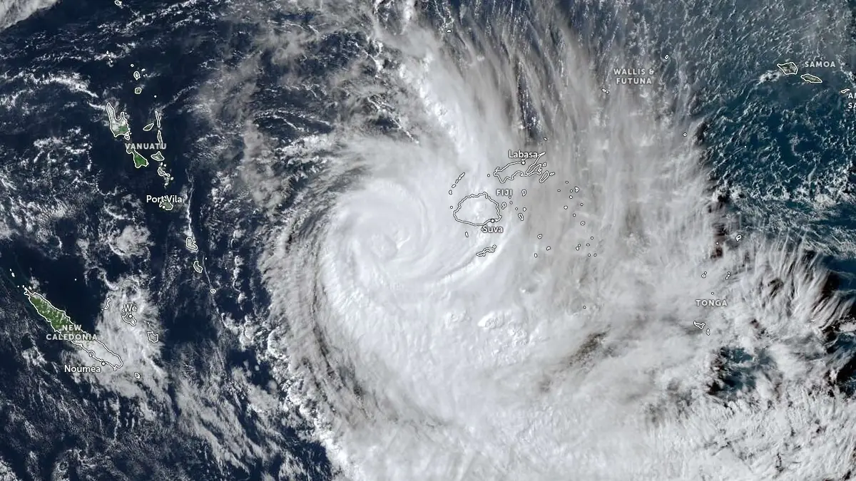
Satellite image of Tropical Cyclone Vaianu at 04:00 UTC on April 7, 2026. Credit: JMA/Himawari-9, Zoom Earth, The Watchers
Category 3 Tropical Cyclone Vaianu is affecting Fiji on April 7, producing heavy rainfall, flooding, and hazardous marine conditions while tracking southeastward toward New Zealand.
At 06:00 UTC today, the system was located approximately 255 km (158 miles) west-southwest of Nadi, with maximum 10-minute sustained winds of 157 km/h (97 mph) and a central pressure of 955 hPa, according to the Fiji Meteorological Service.
The Joint Typhoon Warning Center (JTWC) assessed 1-minute sustained winds at 185 km/h (115 mph) as of 09:00 UTC today, equivalent to a Category 3 cyclone on the Saffir–Simpson scale. The system was located about 348 km (216 miles) west-southwest of Suva and was moving south-southeast at approximately 22 km/h (14 mph). Significant wave heights near the center reached around 12 m (40 feet).
24-hour rainfall totals reaching 130.4 mm (5.13 inches) were recorded in Nadi, 120 mm (4.72 inches) in Lautoka, and 140.5 mm (5.53 inches) in Monasavu.
A heavy rain warning remains in force for the entire Fiji group, with forecasts calling for continued periods of rain, heavy at times, and isolated thunderstorms.
Flash flood warnings are in effect for Viti Levu, with flood warnings issued for low-lying areas along the Tuva, Nadi, and Nawaka rivers. River levels are rising steadily, increasing the risk of flooding in drainage systems, small streams, roads, and properties in flood-prone areas.
Urban flooding and reduced visibility during heavy rainfall are expected to impact transportation and daily activities.
Marine conditions remain dangerous, with gale-force winds affecting Yasawa, Mamanuca, and southwest Viti Levu waters, as well as Kadavu and surrounding passages. Winds in these areas are expected to reach up to 83 km/h (52 mph) with gusts up to 120 km/h (75 mph), generating high seas and damaging swells. Authorities warn of a high risk to all sea travel.
Satellite analysis indicates that the cyclone structure is becoming increasingly affected by moderate to strong vertical wind shear, which is limiting convection on the western side of the circulation and contributing to a weakening eye feature.
Dry air is also intruding into the system’s core from the west and northwest, further impacting its organization despite warm sea surface temperatures of 28-29°C (82-84°F) and strong poleward outflow.
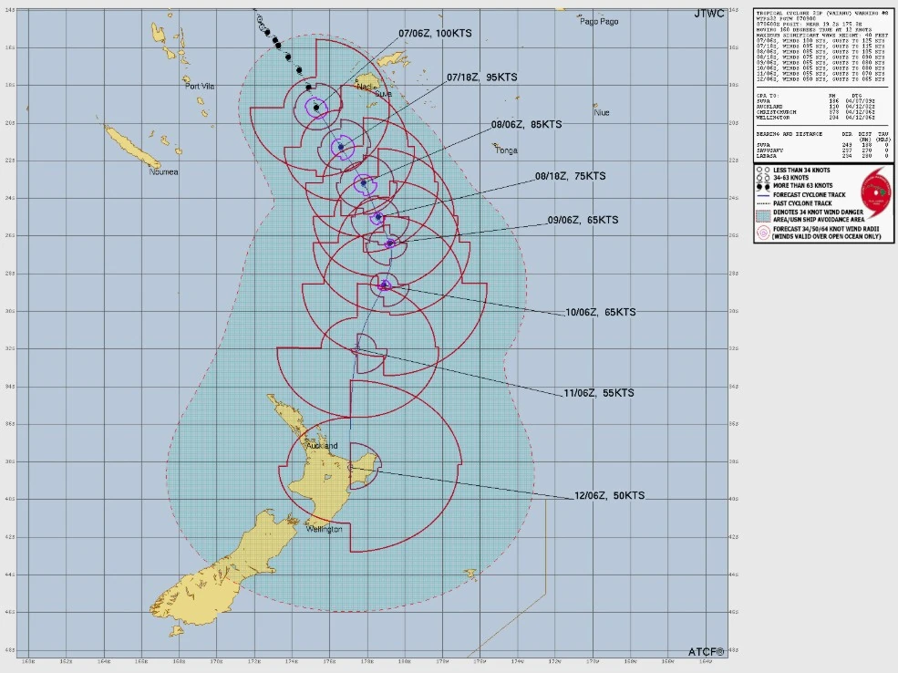
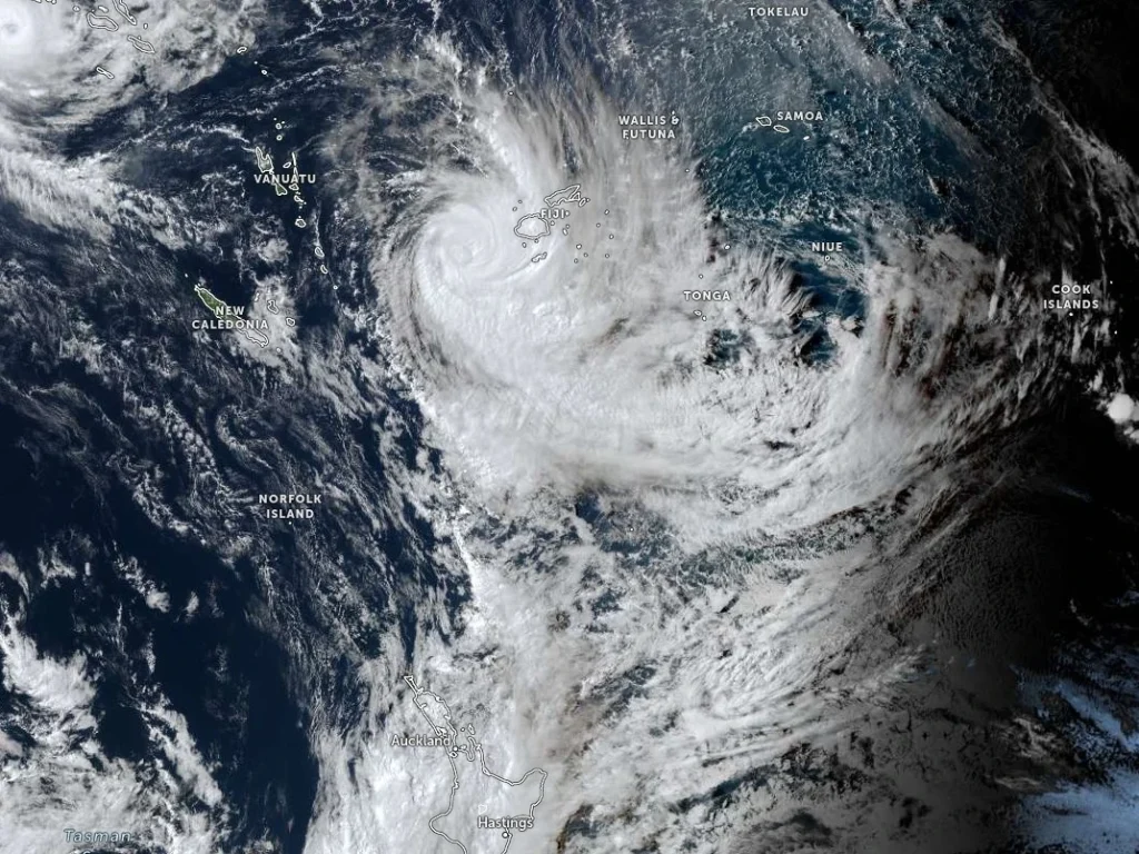
Vaianu is forecast to continue tracking southeastward over the next 48 hours under the influence of a near-equatorial ridge. Beyond this period, the system is expected to turn southward and eventually southwestward as it interacts with mid-latitude features, including an upper-level trough and subtropical jet.
Gradual weakening is forecast as vertical wind shear increases and sea surface temperatures decrease to around 26°C (78.8°F). Despite weakening, the system is expected to maintain winds of approximately 93–102 km/h (58–63 mph) as it undergoes subtropical transition north of New Zealand later in the forecast period.
New Zealand’s MetService reports that Vaianu has the potential to bring strong winds, heavy rain, and large swells to parts of the country toward the end of the week.
The heaviest rainfall is currently forecast across northern and eastern parts of the North Island, although the extent and intensity of impacts remain dependent on the cyclone’s track.
The system follows a typical late-season South Pacific pattern, where tropical cyclones move poleward into cooler waters and higher wind shear, leading to structural weakening and transition into a subtropical or extratropical system.
Even after losing tropical characteristics, the system is expected to remain a deep and active low-pressure system capable of producing severe weather.
Vaianu is the second named storm of the 2025–26 South Pacific cyclone season and the first major cyclone (on the Saffir–Simpson Hurricane Wind Scale) in the South Pacific basin since Lola in October 2023.
References:
1 Tropical Cyclone Vaianu advisory – RSMC Nadi – April 7, 2026
2 Prognostic Reasoning for Tropical Cyclone 31P – JTWC – April 7, 2026
3 Tropical Cyclone Vaianu update – MetService New Zealand – April 7, 2026
I'm a dedicated researcher, journalist, and editor at The Watchers. With over 20 years of experience in the media industry, I specialize in hard science news, focusing on extreme weather, seismic and volcanic activity, space weather, and astronomy, including near-Earth objects and planetary defense strategies. You can reach me at teo /at/ watchers.news.
Commenting rules and guidelines
We value the thoughts and opinions of our readers and welcome healthy discussions on our website. In order to maintain a respectful and positive community, we ask that all commenters follow these rules.