
Severe storms with very large hail, damaging winds and tornadoes expected across the mid-Mississippi and Ohio valleys
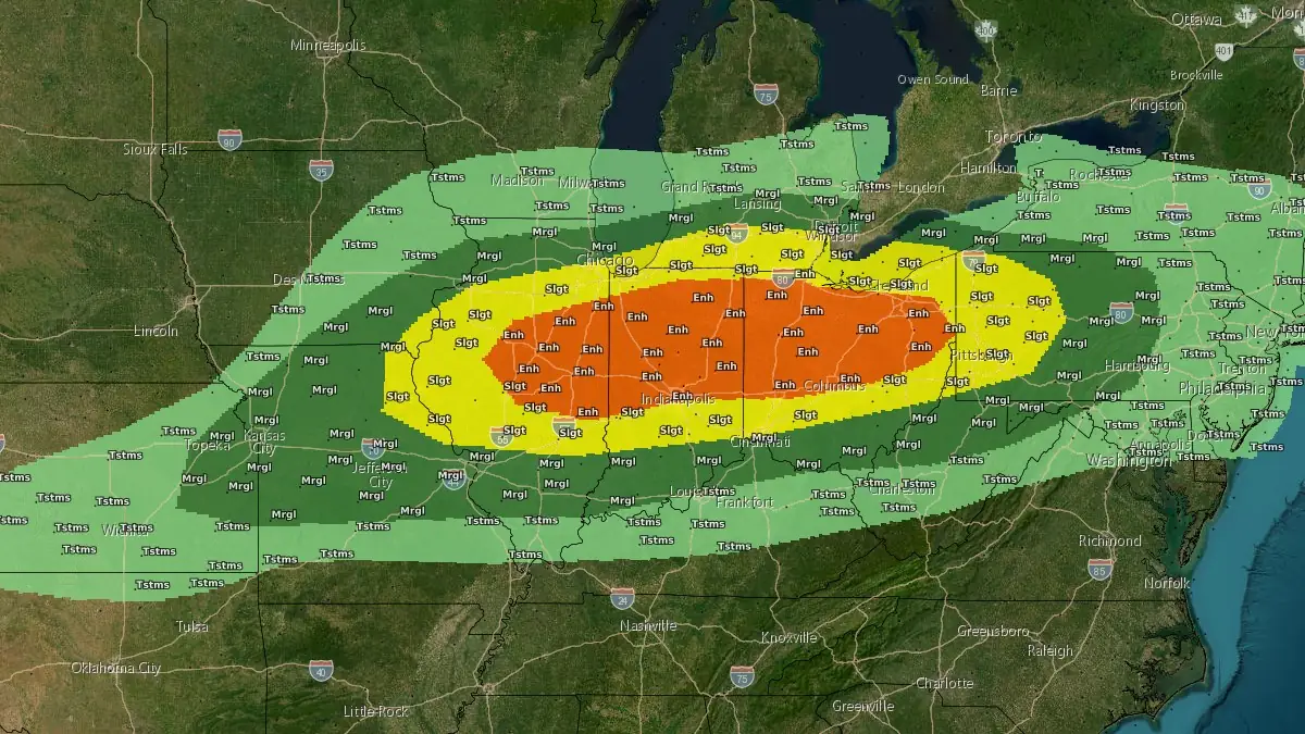
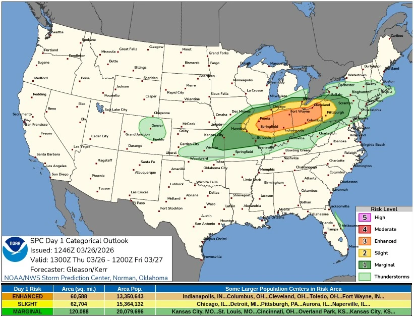
An Enhanced Risk of severe thunderstorms is in place for parts of the mid-Mississippi and Ohio valleys on March 26, 2026, where storms developing late this afternoon are forecast to produce very large hail, damaging wind gusts, and a few tornadoes.
Convective outlook for March 26, 2026. Credit: NWS/SPC
The NWS Storm Prediction Center (SPC) forecasts scattered severe thunderstorms this afternoon and evening, with large to very large hail, severe to damaging winds, and a few tornadoes all appearing likely across the region.
Storms are expected to develop rapidly along a southward-moving cold front from central Illinois into Indiana, southern Lower Michigan, and northern Ohio between 14:00 and 18:00 local time (19:00–22:00 UTC), as daytime heating erodes convective inhibition and allows instability to build within a narrow corridor.
Environmental conditions support organized severe convection despite modest low-level moisture. Forecast values indicate mixed-layer CAPE of approximately 1 000 to 1 500 J/kg, combined with strong mid-level flow of 50 to 60+ kt and deep-layer shear of similar magnitude, sufficient to sustain supercell structures during the initial phase of storm development.
This early phase is expected to favor discrete or semi-discrete supercells capable of producing very large hail.
SPC identified a risk for hail exceeding 5 cm (2 inches) in diameter, supported by steep mid-level lapse rates and strong updraft intensity.

As storms organize along the cold front, a fairly quick transition to more linear structures is expected, with one or more clusters spreading east-southeastward across much of the Ohio Valley into western and central Pennsylvania through the late afternoon and evening.
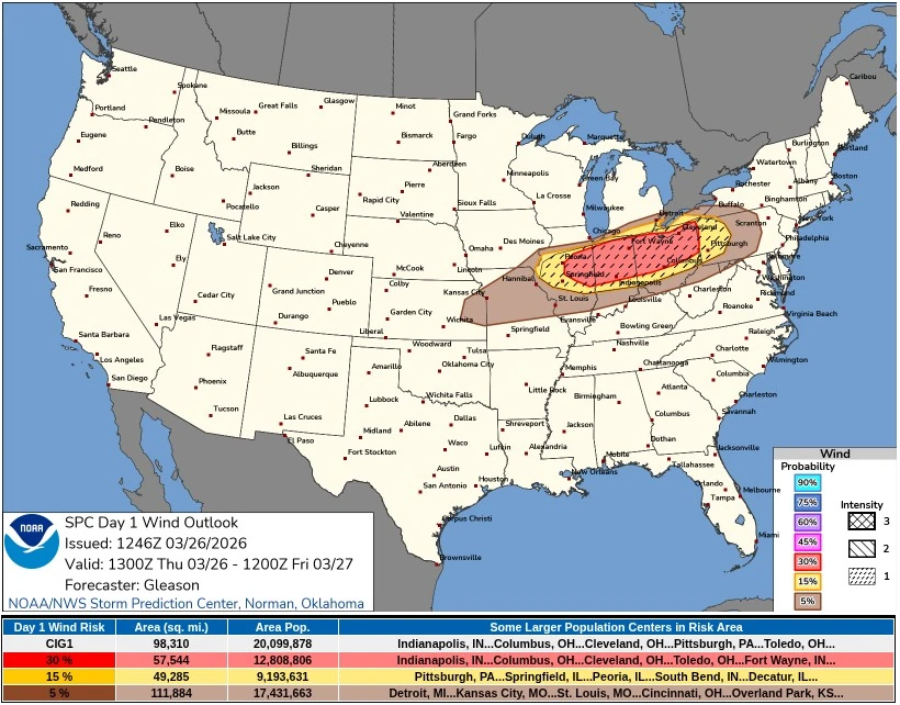
This transition will shift the dominant hazard toward damaging winds.
Isolated wind gusts exceeding 120 km/h (75 mph) are possible, and scattered to numerous severe wind reports may develop as convective lines mature and accelerate eastward.
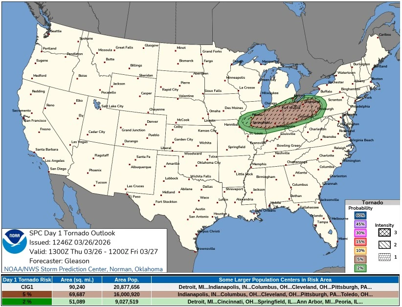
A tornado threat is also present throughout the event, associated with both initial supercells and embedded mesocirculations within evolving line segments.
SPC indicates that a locally greater tornado risk may exist across parts of northern and central Indiana and Ohio, where stronger low-level shear is expected in association with a 35 to 50 kt low-level jet.
Confidence in a more concentrated tornado corridor remains limited, and probabilities were not increased in the latest outlook.
This severe weather setup is associated with a strong cold front advancing southward across the region, interacting with an anomalously warm air mass.
According to the NWS Weather Prediction Center (WPC), temperatures across parts of the central and eastern United States are running 14 to 19°C (25 to 35°F) above average, adding sufficient instability ahead of the boundary.
Behind the front, a sharp temperature drop of 11 to 17°C (20 to 30°F) is forecast, marking a rapid transition to cooler and more stable conditions by Friday, March 27 and Saturday, March 28 across the central and eastern United States.
References:
1 Day 1 Convective Outlook – NWS/SPC – Issued at 12:46 UTC on March 26, 2026
2 Short Range Forecast Discussion – NWS/WPC – Issued at 06:33 UTC on March 26, 2026
I'm a dedicated researcher, journalist, and editor at The Watchers. With over 20 years of experience in the media industry, I specialize in hard science news, focusing on extreme weather, seismic and volcanic activity, space weather, and astronomy, including near-Earth objects and planetary defense strategies. You can reach me at teo /at/ watchers.news.
Commenting rules and guidelines
We value the thoughts and opinions of our readers and welcome healthy discussions on our website. In order to maintain a respectful and positive community, we ask that all commenters follow these rules.