
Flooding concerns grow in Montana as severe storms threaten parts of the Plains
A storm system moving from the Great Basin into the Northern Rockies is expected to bring widespread rain, flooding concerns, and severe thunderstorms across multiple U.S. regions through June 1, 2026. The highest rainfall threat is forecast across portions of Montana on May 30, while severe storms capable of producing damaging winds and large hail are expected across parts of Nebraska and South Dakota.
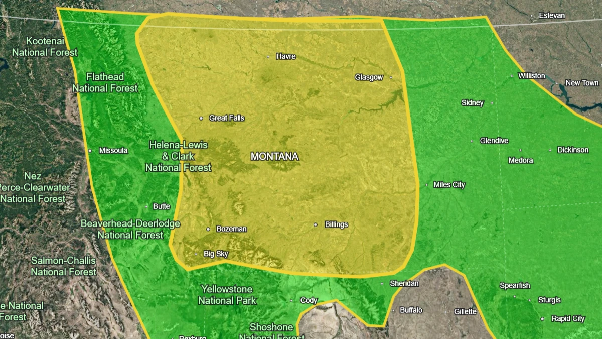
Image credit: NOAA/SPC, Google
A strong late-spring weather pattern will remain in place through the weekend. An upper-level low moving from the Great Basin into the Northern Rockies is forecast to bring widespread rain and thunderstorms from the Northern Rockies into the High Plains.
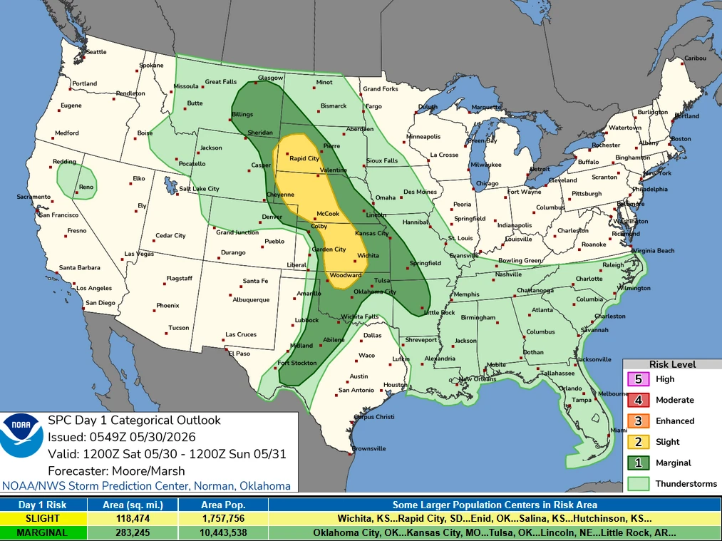
The Weather Prediction Center (WPC) has placed parts of Montana under a Slight Risk (Level 2 of 4) of excessive rainfall on May 30, while the Storm Prediction Center (SPC) has issued a Slight Risk (Level 2 of 5) of severe thunderstorms across parts of western Nebraska and southwestern South Dakota.
Montana will be under the greatest risk of excessive rainfall on May 30. Increasing moisture and large-scale forcing along a frontal boundary are forecast to support moderate to heavy rainfall across portions of the Northern Rockies and adjacent Plains.
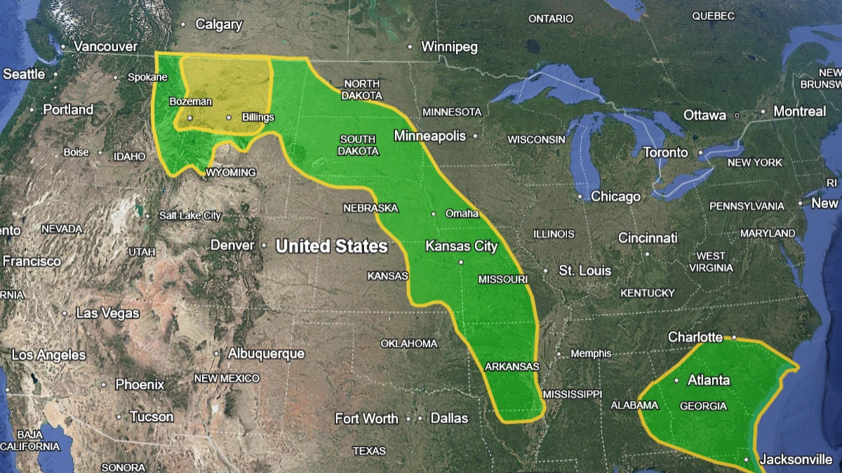
Farther east, a frontal boundary extending across the Plains will interact with northward-moving Gulf moisture, supporting additional rounds of showers and thunderstorms. Locally heavy rainfall is possible along the boundary, and WPC forecasts a Marginal Risk (Level 1 of 4) of excessive rainfall on June 1 extending from Montana southeastward to northern Florida.
Flooding concerns are greatest in burn scars, steep terrain, and other locations where water can run off quickly. Localized flooding is possible where the heaviest rain develops.
Severe weather is also forecast across the Northern and Central Plains, with the SPC issuing a Slight Risk extending from western Nebraska into southwestern South Dakota, and a broader Marginal Risk extending into parts of Nebraska, Kansas, South Dakota, and Texas. Isolated severe wind gusts and large hail are the primary hazards identified in the forecast.
The storm system is forecast to shift eastward on May 31, bringing showers and thunderstorms from the Plains toward the Ozarks and parts of the Southeast.
The severe-weather threat will persist across portions of the Northern Plains and Ozark region as the frontal boundary advances. Additional thunderstorm development is forecast late June 1 into June 2 as the boundary lifts northeastward toward the Mid-Atlantic.
Repeated rounds of showers and thunderstorms are expected through the weekend across the Southeast and Tennessee Valley.
Deep Gulf moisture and a persistent frontal boundary will support locally heavy rainfall, while saturated soils in some areas could lead to flash floods. A reinforcing frontal boundary arriving late on May 30 is forecast to sustain rainfall and thunderstorm activity into May 31.
References:
1 Short Range Forecast Discussion – NWS/WPC – May 30, 2026

I am an Assistant Editor and Severe Weather & Science Journalist at The Watchers, specializing in real-time severe weather coverage, geophysical event reporting, and research-driven scientific analysis. You can reach me at rishav(at)watchers(.)news.
Commenting rules and guidelines
We value the thoughts and opinions of our readers and welcome healthy discussions on our website. In order to maintain a respectful and positive community, we ask that all commenters follow these rules.