
Severe flooding hits Northern Territory and Queensland as rivers reach major levels, Australia
Severe flooding affected parts of Northern Territory and Queensland, Australia during the first week of March 2026 after persistent monsoonal rainfall caused multiple rivers to exceed major flood levels. The Katherine River in Northern Territory peaked at 19.2 m (63 feet) before midnight on March 7, its highest level since 1998, while the Burnett River in Bundaberg, Queensland was forecast to reach about 7.6 m (25 feet) between March 10 and March 11, 2026. Evacuations, road closures, infrastructure disruptions, and widespread flood warnings were issued as rainfall totals exceeded 500 mm (20 inches) in parts of northern Australia.
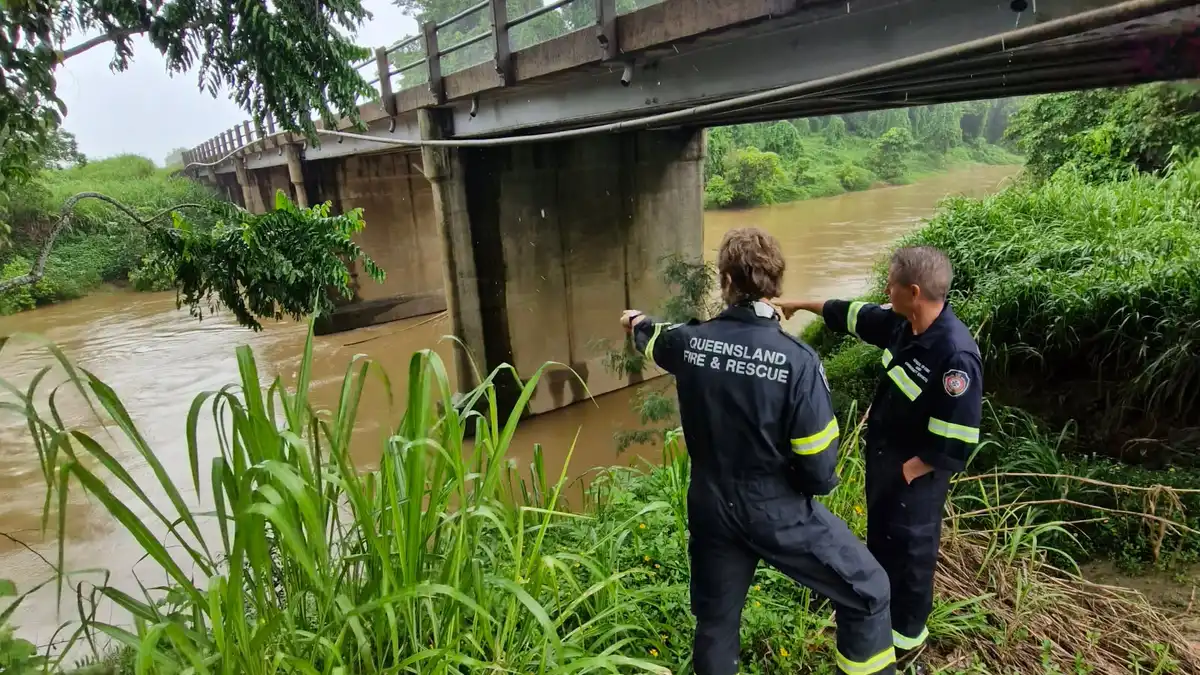
Queensland flooding on March 7, 2026. Credit: Queensland Fire Department
Severe flooding affected large parts of northern Australia during the first week of March 2026 after persistent monsoonal rainfall triggered rapid river rises across multiple catchments in the Northern Territory and Queensland.
The most severe impacts were reported in the town of Katherine, about 320 km (200 miles) southeast of Darwin. Hydrological monitoring showed the Katherine River rising rapidly during the event and reaching approximately 19.2 m (63 feet) at the Katherine Bridge gauge before midnight on March 7. This level represents the highest river stage recorded in the town since the 1998 flood, when the river reached 20.39 m (67 feet).
Floodwaters inundated streets and low-lying areas of Katherine, affecting homes, businesses, and local infrastructure. Authorities issued evacuation advisories for vulnerable areas while emergency shelters were established for residents displaced by the flooding.
Hundreds of residents from remote communities were evacuated to Darwin, including people from Palumpa, Jilkminggan, and Nauiyu along the Daly River. Officials warned that isolated communities could face extended disruption as floodwaters cut road access across large parts of the region.
The flooding followed several days of intense rainfall associated with tropical low-pressure systems embedded within the Australian monsoon trough. These systems transported deep tropical moisture across the Top End and produced widespread heavy rainfall.
Approximately 571.5 mm (22.5 inches) of rain fell within five days at Daly River Police Station, while about 241 mm (9.5 inches) was recorded during the same period at the Katherine Bridge weather station. Weather stations across central and western parts of the Top End recorded rainfall totals between 100–200 mm (4–8 inches).
The Daly River also exceeded major flood levels during the event. Forecasts indicated the river could peak near 15.3 m (50 feet), approaching the level recorded during the 1998 flood when the river reached 16.25 m (53 feet). Authorities warned that flooding along the Daly River could persist for more than a week.
Public health officials issued boil-water advisories for communities including Katherine, Wugularr (Beswick), Tindal, Palumpa, and Nauiyu. Residents were instructed to use boiled or bottled water for drinking, food preparation, and brushing teeth due to possible contamination of water systems.
Flooding disrupted education and public services across the region. Seven schools in Katherine and five schools across the Big Rivers region were closed while authorities assessed safety conditions.
Major transport routes across the Northern Territory were closed due to flooding. Sections of the Stuart, Victoria, Roper, and Buchanan highways, as well as Central Arnhem Road, were reported closed as floodwaters covered roadways and bridges.
Authorities also warned residents to avoid entering floodwaters due to multiple hazards, including strong currents, contamination, and wildlife. Emergency officials reported sightings of both freshwater and saltwater crocodiles in flooded areas, including one observed on a sports field in Katherine.
Flooding also affected large parts of Queensland as persistent rainfall caused multiple rivers to rise rapidly across the state. The Burnett River at Bundaberg reached the major flood level of 7 m (23 feet) shortly before 18:30 LT, rising to 7.22 m (23.7 feet) later in the evening and forecast to peak near 7.6 m (25 feet) between March 10 and March 11, 2026.
Authorities issued evacuation warnings for Bundaberg North, South, Central, and East as floodwaters approached residential areas. Emergency officials advised residents in threatened areas to leave their properties before nightfall while roads remained passable.
Flooding forced the closure of several bridges across affected regions. In Bundaberg, both the Tallon Bridge and Burnett River Bridge were closed as water levels continued rising. In the Fraser Coast region, Lamington Bridge in Maryborough was closed while the Tiaro Bridge was expected to remain closed for several days due to major flooding along the Mary River.
Across Queensland, floodwaters disrupted transportation networks on a large scale. Authorities reported approximately 760 roads affected by flooding statewide, while more than 1 700 residents in the Bundaberg region lost electricity after parts of the power network were shut down for safety.
Major flooding was also reported across several river systems in Queensland. The Mary River at Maryborough was forecast to peak near 6 m (20 feet), while the Mary River at Tiaro was expected to reach approximately 13.5 m (44 feet) during a prolonged major flood peak. Flooding also forced the temporary closure of the Tiaro Water Treatment Plant, which draws water directly from the river.
Major flooding also occurred along Callide Creek at Jambin, which reached 5.45 m (18 feet) and was forecast to peak near 5.7 m (19 feet). Along the Dawson River, flooding was occurring at Baralaba, where river levels were forecast to rise above the major flood level of 9 m (30 feet) and could reach about 13 m (43 feet).
Additional rainfall was recorded across parts of inland Queensland. In Moura, approximately 280 mm (11 inches) of rain fell over several days, contributing to flooding that closed 54 roads across Banana Shire and isolated towns including Cracow, Theodore, and Baralaba.
In the Chinchilla region, rising floodwaters surrounded parts of the town as Charleys Creek was forecast to peak near 6.8 m (22 feet). Images from the area showed floodwaters surrounding the well-known watermelon-themed hall, a local landmark associated with the town’s agricultural identity.
Authorities reported that 54 swift-water rescues were carried out within a 14-hour period after drivers became trapped in rising floodwaters.
The highest rainfall recorded across Queensland in the 24 hours to 09:00 LT was 260 mm (10.2 inches) at Brovinia in the Wide Bay–Burnett region.
The Bureau of Meteorology issued major flood warnings for numerous rivers across Queensland, including the Flinders River, Burnett River, Mary River, Upper Balonne River, Dawson River, Warrego River, Thomson River, Barcoo River, Cooper Creek, Lower Condamine River, Charleys Creek, Baffle Creek, Georgina River, and Eyre Creek.
Meteorologists warned that additional rainfall over already saturated catchments could prolong flooding across both the Northern Territory and Queensland as the wet season continues across northern Australia.
References:
1 ‘A saltwater crocodile on the AFL oval’: worst flooding in decades inundates NT as residents urged to avoid water – The Guardian – March 9, 2026

I’m a science journalist and researcher at The Watchers, contributing to the Epicenter edition, where I cover peer-reviewed scientific research and emerging discoveries across Earth and space sciences. With a background in astronomy and a passion for environmental science, I’ve worked in shark and coral conservation in Fiji, conducting reef and shark-behavior research, contributing to mangrove restoration, and earning PADI Open Water and Coral Reef Certifications. I bring a blend of scientific rigor and storytelling to illuminate the discoveries shaping our planet and beyond.
Commenting rules and guidelines
We value the thoughts and opinions of our readers and welcome healthy discussions on our website. In order to maintain a respectful and positive community, we ask that all commenters follow these rules.