
Record-breaking rainfall leaves dead and missing in New Zealand
Record-breaking rainfall left at least two people dead and several others unaccounted for in parts of New Zealand on January 21, 2026. The event produced multiple rainfall records and damaging winds, marking the 20th Red Warning weather event since the alert level was introduced in May 2019.

Damage in Punaruku, New Zealand after record-breaking rainfall on January 21, 2026. Credit: Tairāwhiti Civil Defence
Red Warnings associated with the tropical low that produced extreme rainfall across parts of New Zealand were lifted on Thursday, January 22, as the system moved eastward away from the country. MetService has confirmed the event as one of the most significant rainfall episodes in recent decades, resulting in multiple daily rainfall records and damaging wind gusts.
Whitianga recorded 247.6 mm (9.75 inches), making it the wettest day on record since observations began in 1987. Tauranga registered 274 mm (10.8 inches), its wettest day on record in data extending back to 1910 while Whakatāne recorded 114.2 mm (4.50 inches), the wettest January day since records began in 1974.
Other locations also experienced exceptionally high 24-hour rainfall totals over the same period, including 309.4 mm (12.2 inches) in Whangamatā, 284.8 mm (11.2 inches) at Waihi Beach, and 190.2 mm (7.5 inches) at Hicks Bay.
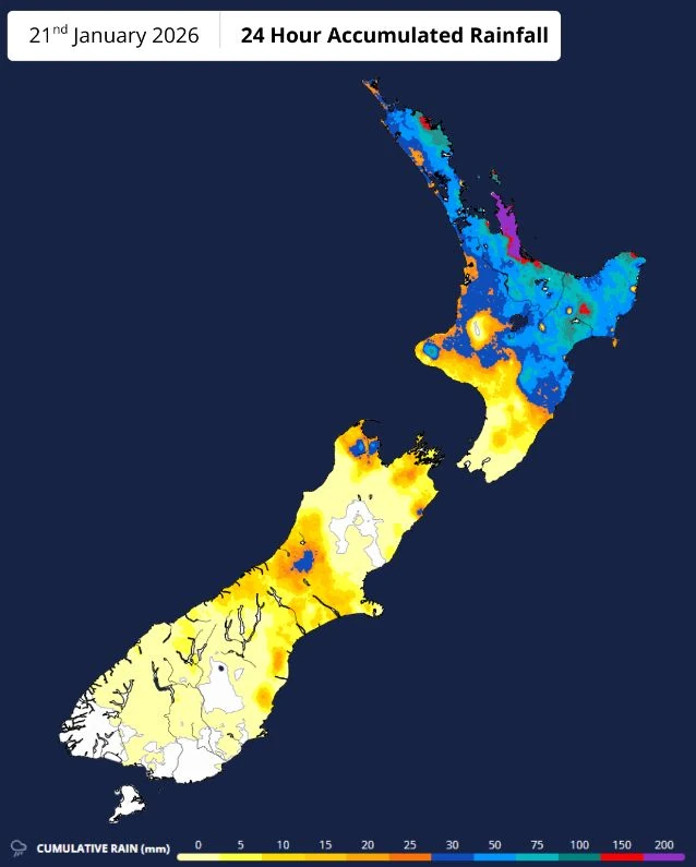
Peak rainfall rates show severe downpours were embedded within broader rain bands. The highest recorded intensity reached 39 mm/h (1.54 inches/h) at the Wētā weather station near Kaeo.
Other peak rates included 33.4 mm/h (1.31 inches/h) at Whangamatā, 32.6 mm/h (1.28 inches/h) at Whitianga, 30.6 mm/h (1.20 inches/h) at Waihi Beach, 32.5 mm/h (1.28 inches/h) at Great Barrier Island, and 25.0 mm/h (0.98 inches/h) at Tauranga.
Peak wind gusts reached 135 km/h (84 mph) at Matamata and 113 km/h (70 mph) at Paeroa.
Authorities have confirmed at least two deaths linked to the storm after a landslide struck a house in the Welcome Bay area near Tauranga. Emergency services said the occupants were trapped during intense rainfall and were later found deceased.
In addition, emergency agencies reported several people unaccounted for following separate incidents associated with flooding and landslides during the event.
A landslide at a coastal campground near Mount Maunganui affected multiple cabins, with officials cautioning that the number of missing remained uncertain as some occupants may have left the area without formally registering their movements.
Searches were also conducted for a man reported missing after floodwaters swept a vehicle into a river north of Auckland, with conditions complicating recovery efforts. Officials said casualty figures and missing-person reports may change as search operations continue and as people are accounted for in affected communities.
Although Red Warnings have been lifted, authorities said recovery efforts are expected to continue, particularly in regions that experienced severe flooding and landslides. Many of the hardest-hit areas are popular holiday destinations, and emergency officials advised travellers to remain mindful of ongoing cleanup and infrastructure disruption during the Auckland Anniversary Day long weekend.
As of January 22, a Heavy Rain Watch remained in place for parts of Canterbury and Marlborough until early afternoon. An Orange Strong Wind Warning and a Heavy Rain Watch were also issued for the Chatham Islands as the low-pressure system continued eastward.
National forecasters said the post-event pattern is expected to shift to cooler southwesterly flow, bringing showers, strong winds, and an elevated risk of thunderstorms and hail to parts of the country through the weekend.
Temperatures are forecast to drop noticeably, with Taupō, Christchurch, Ashburton, and Alexandra expected to reach maximum temperatures of 16°C (61°F) on Saturday, while stronger winds are forecast for Northland and parts of Southland and Otago.
References:
1 Red Warnings Lifted after Record-breaking Rain – MetService – January 22, 2026
I'm a dedicated researcher, journalist, and editor at The Watchers. With over 20 years of experience in the media industry, I specialize in hard science news, focusing on extreme weather, seismic and volcanic activity, space weather, and astronomy, including near-Earth objects and planetary defense strategies. You can reach me at teo /at/ watchers.news.
Commenting rules and guidelines
We value the thoughts and opinions of our readers and welcome healthy discussions on our website. In order to maintain a respectful and positive community, we ask that all commenters follow these rules.