
Damaging ice forecast across parts of the South as high-impact winter storm develops
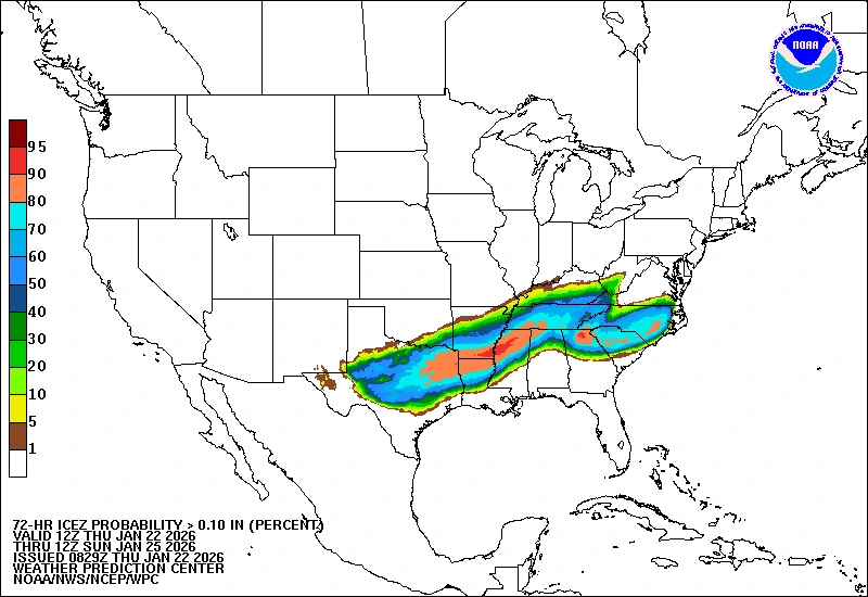
A major long-duration winter storm is forecast to affect large portions of the central and eastern United States starting Friday, January 23, 2026, with confidence increasing in damaging ice accumulations across parts of the South. Heavy snow, sleet, and freezing rain are expected from the southern Rockies and Plains into the Mid-South, with the system spreading east into the Mid-Atlantic and New England through the weekend.

Image credit: NWS/WPC
A large, long-duration winter storm is forecast to bring damaging ice along with heavy snow, sleet, and freezing rain from the southern Rockies and Plains into the Mid-South starting Friday. It will then spread eastward into the Mid-Atlantic and New England over the weekend.
“Confidence continues to increase for damaging ice accumulations across parts of the South,” NWS forecasters said, urging residents in the region to complete preparations as soon as possible.
Heavy snowfall is expected from parts of eastern New Mexico to southern Maine, extending across the Southern Rockies, Plains, and the Mid-Atlantic through the weekend. Up to 15 cm (6 inches) of snowfall is forecast in the affected regions, with localized totals of up to 30 cm (12 inches) being possible.
Freezing rain and sleet will affect parts of the Southern Plains, Lower Mississippi Valley, Tennessee Valley, the Southeast, and Southern Virginia. Damaging ice accumulations could trigger long power outages in these regions. Widespread tree damage and dangerous travel conditions are also expected.
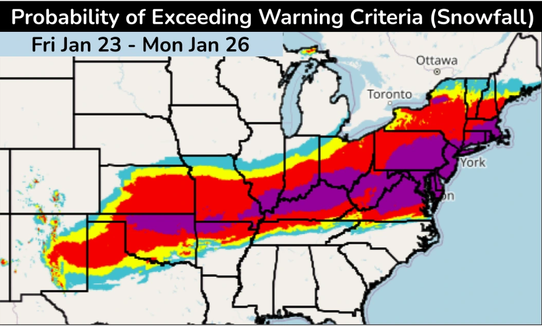
The worst ice and sleet are forecast for the Southern Plains and Lower Mississippi Valley on Friday, shifting east towards the Southeast, Tennessee Valley, and Mid-Atlantic this weekend.
Winter storm watches are in effect from New Mexico to New York, including the entirety of the Tennessee and Ohio Valleys along with parts of the Carolinas, through the weekend. Meanwhile, winter storm warnings are in effect for parts of New York, western and central Oklahoma, and parts of North Texas.

Image credit: NWS/WPC
Impacts of the storm are expected to linger into next week and will be followed by a surge of cold arctic air, which will add to the aftermath.
The Arctic front will bring below-freezing temperatures across the eastern two-thirds of the U.S. through the weekend, reaching the Gulf Coast by Sunday, as the winter storm begins to leave.
Gusty winds accompanying the arctic blast will bring wind chills below -50°F (-45°C) across the Northern Plains. Sub-zero wind chills will reach far into the southeast U.S., affecting the Mid-Atlantic, Mid-Mississippi Valley, and Southern Plains.
The extreme cold is likely to last from the end of January into early February across the affected region. A high risk of hazardous cold is forecast over the Ohio and Tennessee Valleys, along with parts of the Mid-Atlantic and parts of the Southeast between January 29 and February 1.

I am an Assistant Editor and Severe Weather & Science Journalist at The Watchers, specializing in real-time severe weather coverage, geophysical event reporting, and research-driven scientific analysis. You can reach me at rishav(at)watchers(.)news.
Commenting rules and guidelines
We value the thoughts and opinions of our readers and welcome healthy discussions on our website. In order to maintain a respectful and positive community, we ask that all commenters follow these rules.