
Desert rainfall anomaly triggers major flooding across central Australia
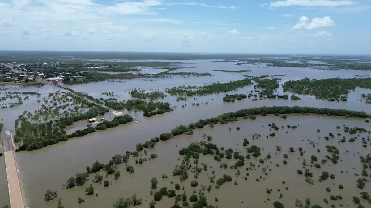
A near-stationary tropical low has triggered one of the most significant inland rainfall events in recent decades, inundating vast areas of central Australia and prompting disaster declarations across the Northern Territory. More than 600 mm (24 inches) of rain has been recorded at some remote stations, with additional heavy rainfall forecast to expand south into South Australia and Victoria through early next week, increasing the risk of further flooding. Meteorologists described it as a remarkable and highly unusual meteorological event.
A wet, isolated Easter is on the cards for Gulf of Carpentaria residents. Credit: Carpentaria Shire Council
A tropical low settled over the Simpson Desert around February 22 and remained positioned over central Australia for nearly a week, an uncommon occurrence for systems of this type in the region.
The system repeatedly drew in deep tropical moisture, producing intense rainfall and embedded thunderstorms across the Northern Territory, outback Queensland, far-west New South Wales, and far-north South Australia.
Ben Domesino of weatherzone described the event as a “remarkable and highly unusual meteorological event,” noting the low barely shifted position between Sunday and Wednesday. Daily 24-hour rainfall totals exceeded 100 mm (4 inches) in several locations, with some remote stations recording totals that approached or exceeded their typical annual averages within days.
At Elkedra Station in the Northern Territory’s Barkly region, more than 600 mm (24 inches) of rain fell over several days, with more than double the station’s average annual rainfall recorded in approximately 48 hours.
Nappa Merrie in south-west Queensland received about 169 mm (6.7 inches) in 24 hours, in an area that typically receives 100–200 mm (4–8 inches) annually. Several additional stations across central Australia reported cumulative totals exceeding 500 mm (20 inches) since the system developed.
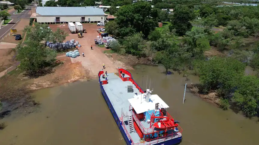
Floodwaters spread across extensive pastoral areas, submerging cattle stations, isolating remote communities, and damaging transport infrastructure.
In the Barkly region, local authorities estimated approximately 85% of roads were impacted by flooding or washouts. Sections of the Stuart Highway between Tennant Creek and Ali Curung were closed, disrupting the primary north–south freight corridor linking Darwin and Adelaide.
In Queensland, floodwaters cut roads servicing Mount Isa, Boulia, and Bedourie, affecting the delivery of food and essential supplies. Rail infrastructure was also impacted, with sections of the east–west corridor near Port Augusta sustaining flood-related damage that temporarily suspended services.
Major flood warnings were issued for river systems including the Georgina and Flinders rivers, with additional warnings across inland catchments in the Northern Territory, Queensland, South Australia, and New South Wales. Emergency services conducted multiple rescues of stranded motorists, including the recovery of a man from the roof of his vehicle near Doomadgee, Queensland.
The extreme weather period also coincided with a confirmed fatality in the Northern Territory. Police located the body of a man who had been reported missing after swimming in the Lander River near Willowra, north-west of Alice Springs.
Authorities stated he was last seen in the river earlier in the week and did not resurface. Search efforts were delayed due to adverse weather conditions. Police have not yet attributed the death directly to flooding.
Both the Northern Territory and federal governments declared the flooding a natural disaster and activated disaster assistance measures. Under the assistance program, primary producers are eligible to claim freight subsidies covering up to 50% of approved costs, capped at AUD 5 000. Eligible non-profit organisations can apply for grants of up to AUD 10 000 to repair significant asset damage.
Cattle station operators reported destroyed fencing, inundated buildings, and severely eroded access roads. Industry representatives renewed calls for the installation of a weather radar at Tennant Creek, noting that the existing radar has been non-operational since 2015. The Bureau of Meteorology (BoM) stated that site finalisation is pending and that a replacement radar could become operational within 12–18 months once installed.
As of February 27, river levels across several inland catchments remained elevated, and soils were saturated, increasing vulnerability to renewed flooding.
Heavy rain and thunderstorms are forecast to continue. The BoM reports that the slow-moving low-pressure system remains active over central Australia and is forecast to expand southward over the weekend.
According to the BoM’s latest Severe Weather Update, an additional 50–200 mm (2–8 inches) of rainfall is expected near the central low. Over the weekend, rainfall will build across South Australia, where southern and central areas could receive 20–150 mm (0.8–6 inches), depending on storm development. By Monday and Tuesday, rainfall is forecast to extend across Adelaide, south-eastern South Australia, and western Victoria, with totals of 50–150 mm (2–6 inches) possible.
A Severe Weather Warning for heavy rainfall remains active for central Australia and has been expanded to the southern coast of South Australia. In the northern parts of the warning area, six-hourly rainfall totals may reach up to 110 mm (4.3 inches), posing a high risk of flash flooding. Six-hourly totals of up to 70 mm (2.8 inches) are possible across parts of South Australia on Saturday as the system deepens.
Flood watches and warnings remain in place across large portions of central and southern Australia, with authorities warning that heavy rain may lead to further river and creek rises in already saturated catchments.
Thunderstorms are forecast from Victoria through South Australia into central Australia on Friday, with the risk continuing into Saturday and shifting east toward Adelaide and western Victoria on Sunday. By Monday and Tuesday, storm activity is forecast to extend further into New South Wales.
Heavy rainfall may lead to flash and river flooding, hazardous travel conditions, and additional road closures. While some agricultural regions in western Victoria and south-eastern South Australia may benefit from replenished soil moisture, the intensity of rainfall may also result in soil erosion and waterlogging in low-lying areas.
Forecast models indicate the system will gradually shift east early next week, with conditions easing from the west across South Australia by Monday. Widespread showers and thunderstorms are expected to persist over southern New South Wales on Tuesday before gradually clearing later in the week.
References:
1 Severe weather update: Heavy rain for central and south-east Australia – BoM – February 27, 2026
2 National weather forecast: A damp end to summer for much of Australia – BoM – February 27, 2026
3 Simpson Desert tropical low causing flooding in four states – weatherzone – February 25, 2026

I’m a science journalist and researcher at The Watchers, contributing to the Epicenter edition, where I cover peer-reviewed scientific research and emerging discoveries across Earth and space sciences. With a background in astronomy and a passion for environmental science, I’ve worked in shark and coral conservation in Fiji, conducting reef and shark-behavior research, contributing to mangrove restoration, and earning PADI Open Water and Coral Reef Certifications. I bring a blend of scientific rigor and storytelling to illuminate the discoveries shaping our planet and beyond.
Commenting rules and guidelines
We value the thoughts and opinions of our readers and welcome healthy discussions on our website. In order to maintain a respectful and positive community, we ask that all commenters follow these rules.