
Heavy rain triggers flash flooding and travel disruption across multiple states in Australia
A broad low-pressure system moving through inland Australia continues to generate intense rainfall and flash flooding on February 25, 2026. Severe weather warnings remain in effect across multiple regions as the Bureau of Meteorology reports rainfall totals exceeding 200 mm (7.9 inches) in parts of South Australia.
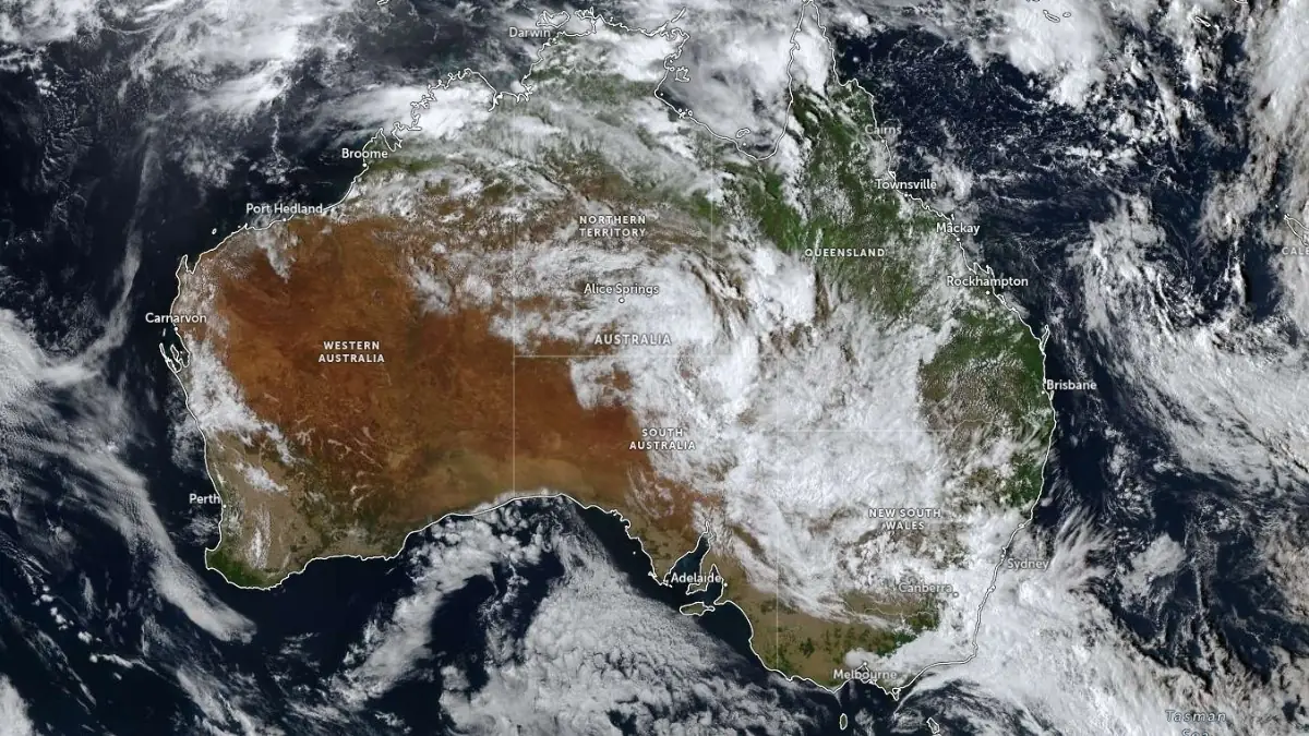
Satellite image acquired at 06:10 UTC on February 25, 2026. Credit: JMA/Himawari-9, Zoom Earth, The Watchers
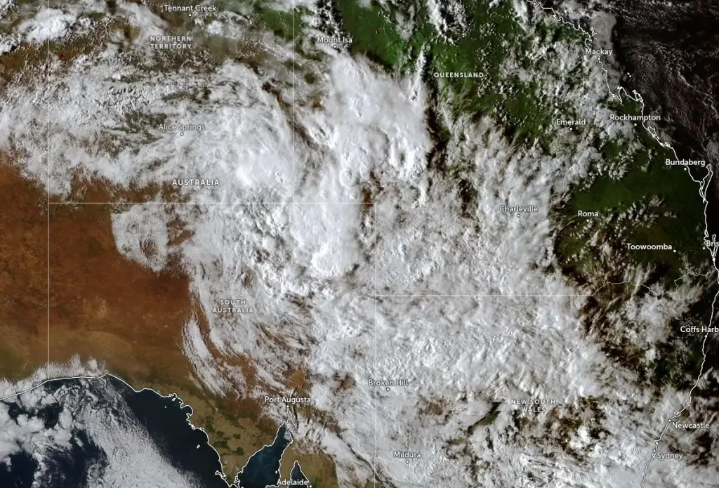
A deep, slow-moving low-pressure system over inland Australia continues to produce widespread heavy rainfall and thunderstorms across large parts of the country on February 25.
The system is drawing humid tropical air from the north into the nation’s interior, leading to persistent rain and flash flooding across South Australia, New South Wales, Victoria, Queensland, and the Northern Territory.
According to the Bureau of Meteorology (BoM), rainfall totals have exceeded 200 mm (7.9 inches) in parts of northern South Australia and Central Australia since the previous evening.
Localized flooding has forced the closure of several outback highways, while sections of the Trans-Australian Railway near Port Augusta have been temporarily suspended due to inundation and washouts.
In Victoria, Melbourne and surrounding districts are experiencing thunderstorms producing 30–60 mm (1.2–2.4 inches) of rain. The Victoria State Emergency Service (VICSES) has received hundreds of calls for assistance following reports of flash flooding, fallen trees, and power outages affecting thousands of customers.
Further north, Queensland and the Northern Territory continue to face widespread flooding across already saturated catchments. Rivers in southern Queensland remain under flood watch, and several highways near Alice Springs and Katherine have been closed or deemed unsafe due to standing water.
Authorities have urged drivers to avoid flood-affected roads and to heed local warnings.
As of 10:30 UTC on February 26, BoM maintains multiple severe weather and flood warnings across eastern and central Australia.
In New South Wales, Severe Thunderstorm Warnings for HEAVY RAINFALL remain active across parts of the Central Tablelands, Southern Tablelands, Central West Slopes and Plains, South West Slopes, and Riverina Forecast Districts.
A separate Severe Weather Warning for HEAVY RAINFALL is in effect for parts of the Upper Western Forecast District, while Minor Flood Warnings remain in place for the Paroo River. Moderate Flood Warnings continue for the Thomson and Barcoo Rivers and Cooper Creek, as well as the Bulloo River. A Flood Watch remains active for parts of the far north west of the state.
In Queensland, Severe Thunderstorm Warnings for HEAVY RAINFALL are active in parts of the North West Forecast District, alongside a Severe Weather Warning for HEAVY, LOCALLY INTENSE RAINFALL covering Channel Country and parts of the Maranoa and Warrego Forecast Districts.
Major Flood Warnings are in effect for the Georgina River and the Flinders River, while Moderate Flood Warnings apply to the Eyre Creek and the Thomson and Barcoo Rivers and Cooper Creek. Flood Warnings extend to the Cloncurry, Nicholson, Gregory, Albert and Leichhardt Rivers, with Minor Flood Warnings issued for the Norman, Paroo (QLD), Cape, Suttor, Burdekin and Herbert Rivers. A Flood Watch also remains in effect for parts of the Gulf of Carpentaria and Cape York Peninsula.
South Australia remains under a Severe Weather Warning for HEAVY, LOCALLY INTENSE RAINFALL in parts of the North East Pastoral district, as well as a Severe Weather Warning for DAMAGING WINDS affecting parts of the Adelaide Metropolitan and Mount Lofty Ranges districts. Flood Warnings remain in place for the Inland Rivers SA, the Diamantina River, and the Western River, while a Flood Watch continues for parts of north-eastern and central South Australia.
In the Northern Territory, a Severe Weather Warning for HEAVY RAINFALL remains active for parts of the Simpson district. Major Flood Warnings apply to the Georgina River, with Moderate Flood Warnings for the Eyre Creek. Flood Warnings also cover the Nicholson, Gregory, Albert, and Leichhardt Rivers.
Victoria remains under a Marine Wind Warning, and a Final Flood Watch is in effect for parts of the Central, Gippsland, and North East Catchments.
Marine Wind Warnings are also active for the coastal waters of Western Australia, South Australia, New South Wales, Queensland, and Tasmania.
In Western Australia, a Heatwave Warning and a Fire Weather Warning are in effect for the Swan Inland North and Swan Inland South districts, alongside a Minor Flood Warning for the Fitzroy River.
Within METAREA 10, Ocean Wind Warnings remain active, including a Storm Force Wind Warning for the Western Area.
Meteorologists attribute the ongoing rainfall to a broad tropical moisture corridor extending from the Gulf of Carpentaria through central Australia, combining with a surface trough and upper-level low.
This configuration is typical of the late-wet-season pattern in the Southern Hemisphere, when moisture from the monsoon region occasionally penetrates deep inland. February climatology supports increased flood potential in northern and central Australia during such episodes.
However, BoM notes that the current system is drawing an unusually deep and persistent corridor of tropical moisture into central and southern parts of the continent. Such inland penetration of sustained tropical humidity is less common this late in the season, particularly when combined with a slow-moving low-pressure system.
National meteorologists warn that conditions remain dynamic, with additional rainfall expected through February 26 as the system slowly shifts eastward.
Emergency services across all affected states are advising residents to remain vigilant as further rainfall may lead to renewed flash flooding.
References:
1 Severe weather and flood warnings – BoM – February 25, 2026
2 Victorians urged to prepare now ahead of forecast storms – Victoria SES – February 23, 2026
I'm a dedicated researcher, journalist, and editor at The Watchers. With over 20 years of experience in the media industry, I specialize in hard science news, focusing on extreme weather, seismic and volcanic activity, space weather, and astronomy, including near-Earth objects and planetary defense strategies. You can reach me at teo /at/ watchers.news.
Commenting rules and guidelines
We value the thoughts and opinions of our readers and welcome healthy discussions on our website. In order to maintain a respectful and positive community, we ask that all commenters follow these rules.