
Late-February 2026 Nor’easter sets all-time snowfall records and leaves 650 000 without power across Northeast U.S.
A rapidly intensifying Nor’easter brought record-breaking snowfall, hurricane-force winds, and major disruptions across the northeastern United States on February 23, 2026. Providence, Rhode Island, recorded 96.3 cm (37.9 inches) of snow, the highest single-storm total on record, while power outages peaked above 650 000 customers and more than 11 000 flights were canceled nationwide. Officials confirmed at least four storm-related fatalities in Maryland and Pennsylvania.
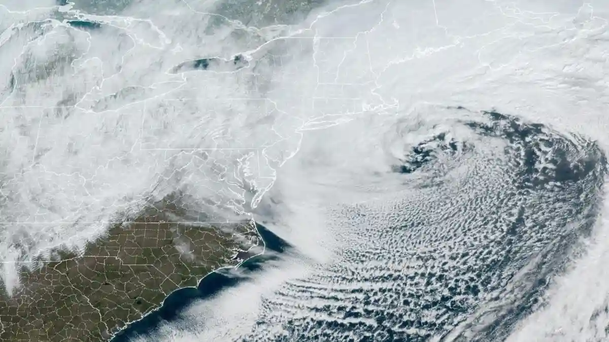
Satellite image showing large offshore Nor'easter impacting the Northeast U.S. on February 23, 2026. Credit: NOAA/NESDIS/STAR GOES-19
A rapidly deepening coastal low tracked northward along the U.S. East Coast from February 22 to 23, 2026, evolving into a powerful Nor’easter that brought blizzard conditions across much of the Northeast. Snow began late Sunday, February 22 and intensified overnight as the system underwent bombogenesis offshore, producing hurricane-force gusts, heavy snow bands, and whiteout conditions from Maryland to Maine.
Two people were killed and another seriously injured after a large tree fell onto a moving vehicle in Calvert County, Maryland on February 22. On the same day in Lower Nazareth Township, Pennsylvania, a pickup truck and a sedan collided on Route 191 as the winter storm began intensifying, killing both drivers.
Power outages peaked at more than 650 000 customers across the Northeast at the height of the storm. Over 289 000 customers were out of power in Massachusetts, followed by New Jersey with 125 000 and Delaware with 67 000. Rhode Island, New York, Maryland, and Virginia reported tens of thousands combined. Restoration efforts reduced totals by Tuesday, though significant service disruptions persisted in parts of Massachusetts.
As of 15:30 EST (19:30 UTC) on February 24, 237 688 customers in Massachusetts were still without power, according to PowerOutage. New Jersey followed with 27 281 and Delaware with 20 767.
Blizzard warnings were issued for more than 40 million people across eight states, including New York, New Jersey, Pennsylvania, Connecticut, Rhode Island, Massachusetts, Delaware, and Maryland.
The National Weather Service (NWS) reported sustained winds or frequent gusts exceeding 56 km/h (35 mph) with visibility reduced to 0.4 km (0.25 mile) or less due to falling and blowing snow for several hours. Snowfall rates reached 5–8 cm (2–3 inches) per hour within the most intense bands.
The storm’s central pressure fell approximately 40 hPa in 24 hours as it tracked northward offshore, exceeding bombogenesis criteria for that latitude. The resulting pressure gradient produced hurricane-force gusts along portions of the New England coastline.
Exposed sites in coastal Massachusetts recorded gusts approaching 158 km/h (98 mph), while Montauk, New York, measured gusts near 135 km/h (84 mph).
Providence, Rhode Island registered 96.3 cm (37.9 inches) of snow at T.F. Green International Airport, surpassing the previous storm-total record of 72.6 cm (28.6 inches) set during February 6–7, 1978.
In addition to the storm-total record, 90.2 cm (35.5 inches) fell in a single day, breaking the previous one-day snowfall record of 48.3 cm (19 inches) set on January 8, 1996. The 90.2 cm daily total also set a new February 23 record, surpassing the previous 9.7 cm (3.8 inches) set in 1967.
Elsewhere across southern New England, the NWS office in Norton, Massachusetts, recorded 80.8 cm (31.8 inches), Berkley measured 78.7 cm (31 inches), and Stonington, Connecticut, reported 78.2 cm (30.8 inches). Storm totals exceeded 60 cm (24 inches) across parts of southern New England and the Mid-Atlantic corridor.
Islip, New York, recorded 73.9 cm (29.1 inches), and Newark, New Jersey, measured 68.8 cm (27.1 inches), marking its second-largest snowstorm on record. Central Park in New York City recorded 50 cm (19.7 inches), placing the event among the city’s ten largest snowfalls.
Over 11 000 flights were canceled nationwide through Tuesday as major hubs, including Boston Logan, John F. Kennedy, LaGuardia, Newark, and Philadelphia, suspended or reduced operations.
Travel bans were implemented in New York City and across Rhode Island, and non-emergency vehicle restrictions were enacted in parts of Delaware. Congressional votes in Washington, D.C., were postponed due to the storm.
Coastal Flood Advisories were issued for portions of New Jersey and Delaware, with widespread minor tidal flooding reported along the Atlantic coastline and Delaware Bay. As snowfall ended early Tuesday, temperatures fell below freezing, producing refreeze conditions and black ice on treated roadways.
According to NWS Weather Prediction Center (WPC), conditions will improve across the Northeast today. However, power outages could linger due to strong winds and the heavy, wet snow that has fallen.
References:
1 Decision Support Briefing #8 – NWS – February 23, 2026
2 Record Report – NWS – February 23, 2026
3 Storm Summary #5 – Late February Nor’easter – NWS/WPC – Issued at 09:00 UTC on February 24, 2026

I’m a science journalist and researcher at The Watchers, contributing to the Epicenter edition, where I cover peer-reviewed scientific research and emerging discoveries across Earth and space sciences. With a background in astronomy and a passion for environmental science, I’ve worked in shark and coral conservation in Fiji, conducting reef and shark-behavior research, contributing to mangrove restoration, and earning PADI Open Water and Coral Reef Certifications. I bring a blend of scientific rigor and storytelling to illuminate the discoveries shaping our planet and beyond.
Commenting rules and guidelines
We value the thoughts and opinions of our readers and welcome healthy discussions on our website. In order to maintain a respectful and positive community, we ask that all commenters follow these rules.