
Damaging winds, hazardous surf and alpine snow impact south-eastern Australia
A multi-hazard weather system began affecting south-eastern Australia on March 26, 2026, bringing severe thunderstorms to parts of New South Wales, followed by damaging winds, hazardous surf along the NSW coast, a sharp temperature drop, and snow in alpine areas. Forecasts through March 28 called for gusts up to 120 km/h (75 mph) in exposed coastal areas, offshore wave heights of several meters, and wintry conditions over higher terrain, while NSW SES reported hundreds of storm-related incidents during the initial phase of the event.
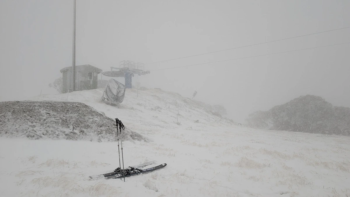
Snow in Hotham on March 26, 2026. Credit: Andy Tranter/BOM
Severe thunderstorms developed across parts of New South Wales during the afternoon and evening hours of March 26, associated with a cold front moving through south-eastern Australia.
The storms produced heavy rainfall, damaging winds, and isolated large hail, with the highest risk concentrated across southern and eastern areas, including Sydney, the Illawarra, and Wollongong, between 16:00 and 19:00 LT.
Emergency response data confirmed significant impacts during the initial phase of the event. According to the New South Wales State Emergency Service (NSW SES), crews responded to 591 incidents in the 24 hours to 14:00 LT on March 27, with the majority of reports originating from Dubbo and Sydney’s Northern Beaches.
Wind gusts reached 115 km/h (71 mph) in Dubbo, according to NSW SES, resulting in widespread damage, including the collapse of a crane in the central business district and numerous fallen trees affecting homes and infrastructure.
The convective phase transitioned into a broader synoptic-scale wind event as a low-pressure system developed and deepened off the east coast of southern New South Wales on March 27. This system generated a strong pressure gradient, producing widespread damaging winds across eastern Victoria, Tasmania, New South Wales, and the Australian Capital Territory.
Forecast wind gusts were expected to reach 100 km/h (62 mph) across eastern Victoria, including the Central Ranges north of Melbourne, with locally heavy rainfall affecting East Gippsland. Rainfall totals of 60–80 mm (2.4–3.1 inches) in 6 hours may lead to localized flash flooding and river rises in the region.
According to NSW SES and Bureau of Meteorology (BOM) forecasts, damaging winds of 100–110 km/h (62–68 mph) were expected across New South Wales, with locally destructive gusts up to 120 km/h (75 mph) possible along the Illawarra coast, including around Jervis Bay.
Areas from Wollongong to Eden were expected to experience the strongest widespread gusts near 110 km/h (68 mph), capable of bringing down trees and powerlines, damaging property, and disrupting transport networks.
As the low-pressure system intensified offshore, the hazard focus shifted toward marine and coastal impacts. Large and powerful waves developed along the New South Wales coastline from the Victorian border to Seal Rocks, driven by persistent strong onshore winds. Offshore wave heights were forecast to reach 6–8 m (20–26 feet), with nearshore waves of 4–5 m (13–16 feet).
Severe weather conditions were expected to result in coastal erosion, particularly along south-facing beaches, and create hazardous conditions for marine activities. NSW SES crews conducted door-knocking operations in at-risk coastal erosion areas on the Central Coast, advising residents and preparing communities for potential impacts.
“Even though the thunderstorms have passed, this system is now bringing a different set of risks with strong winds and dangerous surf expected right along the coast,” said NSW SES State Duty Commander, Assistant Commissioner Dean Storey.
“If you’re near the coast, avoid boating, exposed beaches, rock platforms, and ocean pools. Conditions like this mean no one should be in, on, or around the open ocean.”
Rainfall totals following the initial storm phase were forecast to remain relatively low, generally between 10–40 mm (0.4–1.6 inches) over 24 hours, with no further thunderstorm development expected as the hazard profile shifted toward wind and coastal impacts.
The system also introduced a markedly colder air mass into south-eastern Australia. Forecasts indicated Sydney’s maximum temperature would fall from around 30°C (86°F) on March 26 to near 20°C (68°F) on March 27, while Canberra was forecast to remain in the mid-teens.
Forecast temperatures on March 27 pointed to an unusually sharp cool change across parts of south-eastern Australia, with some inland locations in New South Wales and the ACT facing their coldest March day in years. Forecast guidance cited Canberra near 15°C (59°F), while Melbourne and Sydney were also expected to record notably cooler daytime maxima.
According to BOM, the first snowfall of the 2026 season was observed across the alpine regions of south-eastern Australia as a very cold air mass moved through. Snowfall occurred primarily above elevations of 1200–1400 m (3 900–4 600 feet), with minor accumulations observed. BOM reported minimum temperatures below 0°C (32°F) at multiple alpine locations, including −2.2°C (28°F) at Mount Hotham and −1.7°C (29°F) at Mount Buller.
The low-pressure system was forecast to move slowly eastward through March 28, allowing strong winds to persist over coastal and marine areas even as conditions gradually eased over inland regions. Hazardous surf and elevated coastal risk were expected to continue into the weekend before conditions began to moderate.
References:
1 Strong winds and dangerous surf to impact NSW coast as clean-up continues from overnight storm – NSW – March 27, 2026
2 Hazardous Surf Warning – BOM – March 27, 2026

I’m a science journalist and researcher at The Watchers, contributing to the Epicenter edition, where I cover peer-reviewed scientific research and emerging discoveries across Earth and space sciences. With a background in astronomy and a passion for environmental science, I’ve worked in shark and coral conservation in Fiji, conducting reef and shark-behavior research, contributing to mangrove restoration, and earning PADI Open Water and Coral Reef Certifications. I bring a blend of scientific rigor and storytelling to illuminate the discoveries shaping our planet and beyond.
Commenting rules and guidelines
We value the thoughts and opinions of our readers and welcome healthy discussions on our website. In order to maintain a respectful and positive community, we ask that all commenters follow these rules.