
Ground uplift confirms ongoing magma intrusion beneath Mount Kupreanof, Alaska
New satellite measurements showing ground uplift around Mount Kupreanof have confirmed an ongoing magmatic intrusion beneath the volcano, adding a third line of evidence to months of elevated seismic activity and sulfur dioxide emissions. The Alaska Volcano Observatory (AVO) said the Aviation Color Code remains at Yellow and Volcano Alert Level at Advisory, with no indications from available data that an eruption is imminent.
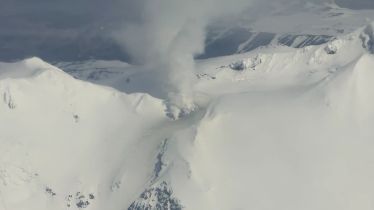
Vigorous steaming is visible from the persistently active fumarole field to the west of the summit of Mount Kupreanof in this oblique aerial photo taken on June 5, 2026. Although steaming in this location is typical, the degassing plume now contains more sulfur dioxide, indicating that magma has intruded to relatively shallow levels beneath the volcano. Credit: Carson Klemp.
New satellite measurements showing ground uplift around Mount Kupreanof have confirmed an ongoing magmatic intrusion beneath the volcano, adding to months of elevated seismic activity and sulfur dioxide emissions documented by the Alaska Volcano Observatory (AVO).
Elevated seismicity and sulfur dioxide (SO2) emissions have continued since the observatory raised the alert level to YELLOW/ADVISORY on May 12.
Newly available satellite deformation measurements provide an additional line of evidence that magma has intruded beneath Mount Kupreanof.
The unrest began in February 2026 and has continued through June. Since the alert-level change on May 12, more than 30 earthquakes of magnitude 1.0 or greater have been detected beneath the volcano.
The largest events occurred on June 15 and 16 and measured M3.2 and M3.6, respectively. AVO reported that shallow seismicity has remained elevated throughout the current unrest episode.
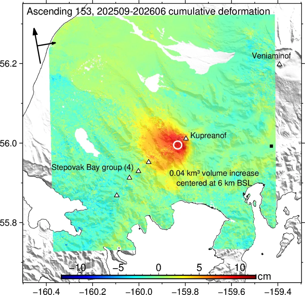
Ground deformation data obtained using satellite interferometric synthetic aperture radar (InSAR) provide additional evidence of the intrusion.
Measurements collected in mid-June, following seasonal snowmelt, show that uplift occurred sometime during the approximately eight-month period following September 30, 2025. AVO estimates the source of the inflation signal is located about 6 km (3.7 miles) below sea level.
The deformation measurements are consistent with the seismic and gas observations and indicate that magma has intruded to relatively shallow depths beneath the volcano.
Satellite observations have continued to detect sulfur dioxide emissions from the volcano. Since May 12, elevated SO2 emissions have been identified on 13 separate days, with estimated emission rates ranging from 100 to 800 tons per day.
According to AVO, the emissions are consistent with degassing from relatively shallow magma beneath the volcano. The observatory noted in its June 23 daily update that sulfur dioxide emissions remained visible in satellite imagery despite widespread cloud cover over the region.
Monitoring of seismic activity at Mount Kupreanof is limited because the volcano does not have a local real-time geophysical monitoring network. The nearest functioning seismic station is located approximately 27 km (17 miles) east of the volcano at Mount Veniaminof.
As a result, many smaller earthquakes below magnitude 2 are not detected or located, and earthquake locations carry relatively large uncertainties. In addition to regional seismic stations, AVO relies on satellite observations, remote infrasound and lightning networks, and visual reports from pilots and mariners operating in the region.
Despite the ongoing unrest, AVO reported no major changes at the active fumarole field located west of the summit at approximately 1 524 m (5 000 feet) elevation. Persistent steam emissions continue from the fumarole area, but no significant changes associated with the current intrusion have been observed.
The earthquake activity, sulfur dioxide emissions, and deformation signal indicate that magma has intruded to relatively shallow depths beneath Mount Kupreanof.
Magmatic intrusions do not always culminate in eruptions, and the current unrest could decline without eruptive activity occurring. If magma rises closer to the surface, the observatory expects additional unrest, including changes in earthquake activity, increased gas emissions, and surface heating that could provide advance warning before an eruption.
Hazards in the case of eruptive activity could include pyroclastic flows, lahars, volcanic ashfall, and airborne ash clouds. Because of the volcano’s remote location, pyroclastic flows would likely remain confined to uninhabited areas surrounding the volcano.
Lahars generated by melting snow and ice could inundate rivers north and south of the volcano, while volcanic ash could affect nearby waters and communities depending on the eruption size and prevailing winds. Airborne ash clouds could also disrupt regional and international aviation routes.
Mount Kupreanof is a heavily glaciated stratovolcano on the Alaska Peninsula with no known historical eruptions. Very little is known about its eruptive history. Geological mapping has identified a suspected Holocene-age debris-flow or block-and-ash-flow deposit south of the volcano. A vigorous fumarole field west of the summit continues to produce persistent steam plumes.
References:
1 Kupreanof Volcano Daily Update – AVO – June 23, 2026
2 Kupreanof Information Statement – AVO – June 22, 2026

I am an Assistant Editor and Severe Weather & Science Journalist at The Watchers, specializing in real-time severe weather coverage, geophysical event reporting, and research-driven scientific analysis. You can reach me at rishav(at)watchers(.)news.
Commenting rules and guidelines
We value the thoughts and opinions of our readers and welcome healthy discussions on our website. In order to maintain a respectful and positive community, we ask that all commenters follow these rules.