
Tropical Storm Sinlaku strengthens, rapid intensification forecast as it tracks toward Guam
Tropical Storm Sinlaku formed on April 9, 2026, in the western Pacific and strengthened to 102 km/h (63 mph) by 15:00 UTC on April 10, approximately 904 km (562 miles) southeast of Andersen Air Force Base, Guam. The system is becoming more organized and is forecast to undergo rapid intensification while tracking toward the Mariana Islands, with a potentially dangerous passage near or over Guam.
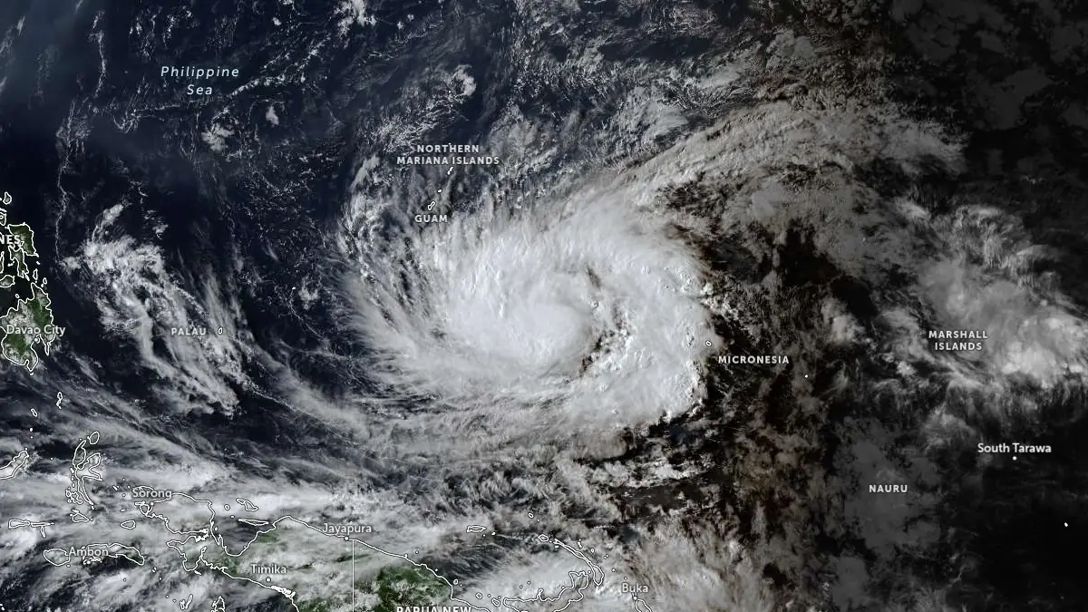
Satellite image of Tropical Storm Sinlaku at 06:50 UTC on April 10, 2026. Credit: JMA/Himawari-9, Zoom Earth, The Watchers
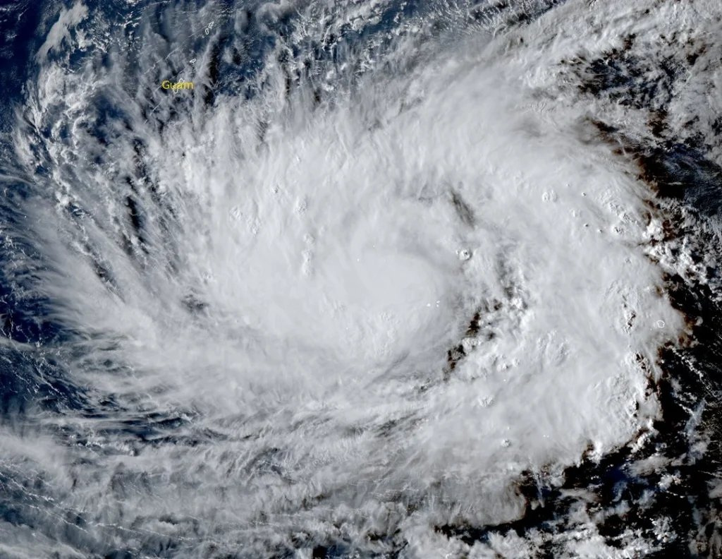
Tropical Storm Sinlaku developed from a low-pressure system identified on April 8 and was upgraded to a tropical depression on April 9 before reaching tropical storm strength later that day. Satellite imagery now shows an expanding central dense overcast and a vortex that is becoming vertically aligned.
At 15:00 UTC on April 10, Sinlaku had maximum sustained winds of 102 km/h (63 mph), according to the Joint Typhoon Warning Center (JTWC), and was slowly moving southwestward at approximately 2 km/h (1 mph).
Convective activity has intensified significantly, with very cold cloud-top temperatures reaching approximately −97°C (-142°F). Observations from Chuuk reported wind gusts up to 89 km/h (55 mph) and a mean sea-level pressure of 986.8 hPa, supporting the assessment of a strengthening system.
Environmental conditions remain favorable, with sea surface temperatures of 28–29°C (82-84°F), abundant deep-layer moisture, and robust poleward outflow. Vertical wind shear has increased slightly but is being offset by improved structural organization, allowing the system to resist disruptive effects.
Scatterometer data continues to show some asymmetry in the wind field. However, the expanding convection on the upshear side suggests that the system is overcoming these limitations. The improved convective structure and inner-core development indicate that Sinlaku is entering a phase conducive to rapid intensification.
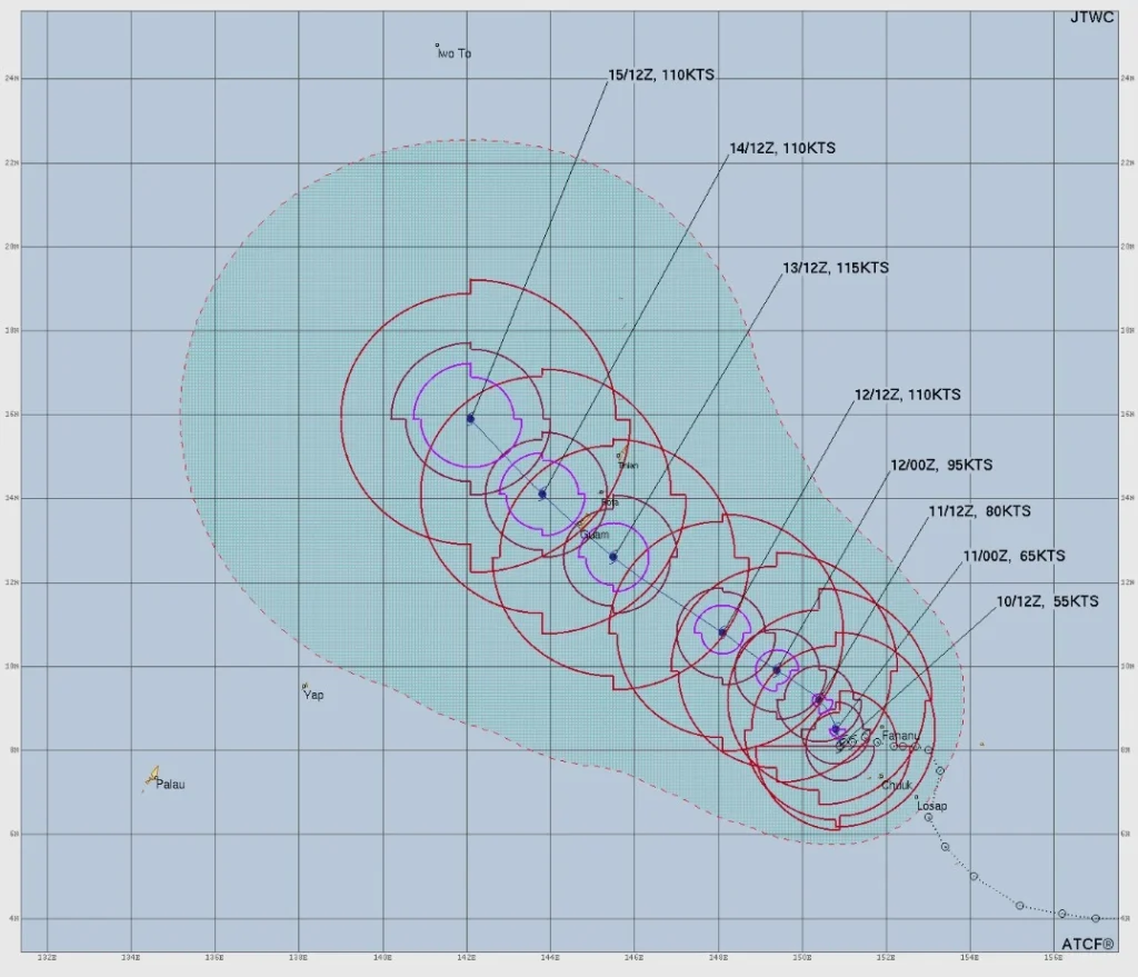
Forecast guidance calls for continued strengthening, with rapid intensification expected between 12 and 48 hours. The system is forecast to reach at least 213 km/h (132 mph) within 72 hours, placing it in the strong typhoon category.
Rapid intensification probabilities are elevated, with model guidance indicating more than a 50 percent chance of a 83 km/h (52 mph) increase in wind speed within 36 hours.
The track forecast indicates a turn toward the north-northwest within the next 12 to 18 hours, followed by a faster northwestward motion as the subtropical ridge weakens and retreats. This places the Mariana Islands, including Guam, within a high-impact uncertainty zone.
Forecast guidance increasingly supports a track passing south of Guam or over its southern tip. However, the uncertainty envelope includes the northern Mariana Islands, including Rota, Tinian, and Saipan. Even small deviations in track could significantly alter the distribution of impacts across the region.
Potential hazards for Guam include damaging winds, heavy rainfall, and dangerous marine conditions. Significant wave heights are currently estimated at approximately 5.5 m (18 feet) and are expected to increase as the system intensifies. Heavy rainfall could lead to flooding, particularly in low-lying and flood-prone areas.
The system’s large wind field increases the likelihood of widespread impacts across the Mariana Islands, even if the center does not pass directly over land. Prolonged exposure to strong winds and heavy rainfall may occur due to the system’s initial slow movement.
References:
1 Tropical Storm Sinlaku Warning #6 – JTWC – Issued at 15:00 UTC on April 10, 2026
I'm a dedicated researcher, journalist, and editor at The Watchers. With over 20 years of experience in the media industry, I specialize in hard science news, focusing on extreme weather, seismic and volcanic activity, space weather, and astronomy, including near-Earth objects and planetary defense strategies. You can reach me at teo /at/ watchers.news.
Commenting rules and guidelines
We value the thoughts and opinions of our readers and welcome healthy discussions on our website. In order to maintain a respectful and positive community, we ask that all commenters follow these rules.