
Moderate Risk of excessive rainfall issued for Tri-State area as heavy rain threatens parts of the Northeast
A Moderate Risk of excessive rainfall and potentially significant flash flooding is in effect for parts of New Jersey, New York, and Connecticut on Tuesday, July 28, 2026, as an unusually strong upper-level low develops over the Northeast. The National Weather Service’s Weather Prediction Center warns that repeated thunderstorms may produce rainfall rates of up to 51 mm (2 inches) per hour, with the greatest threat centered on the New York City tri-state region.
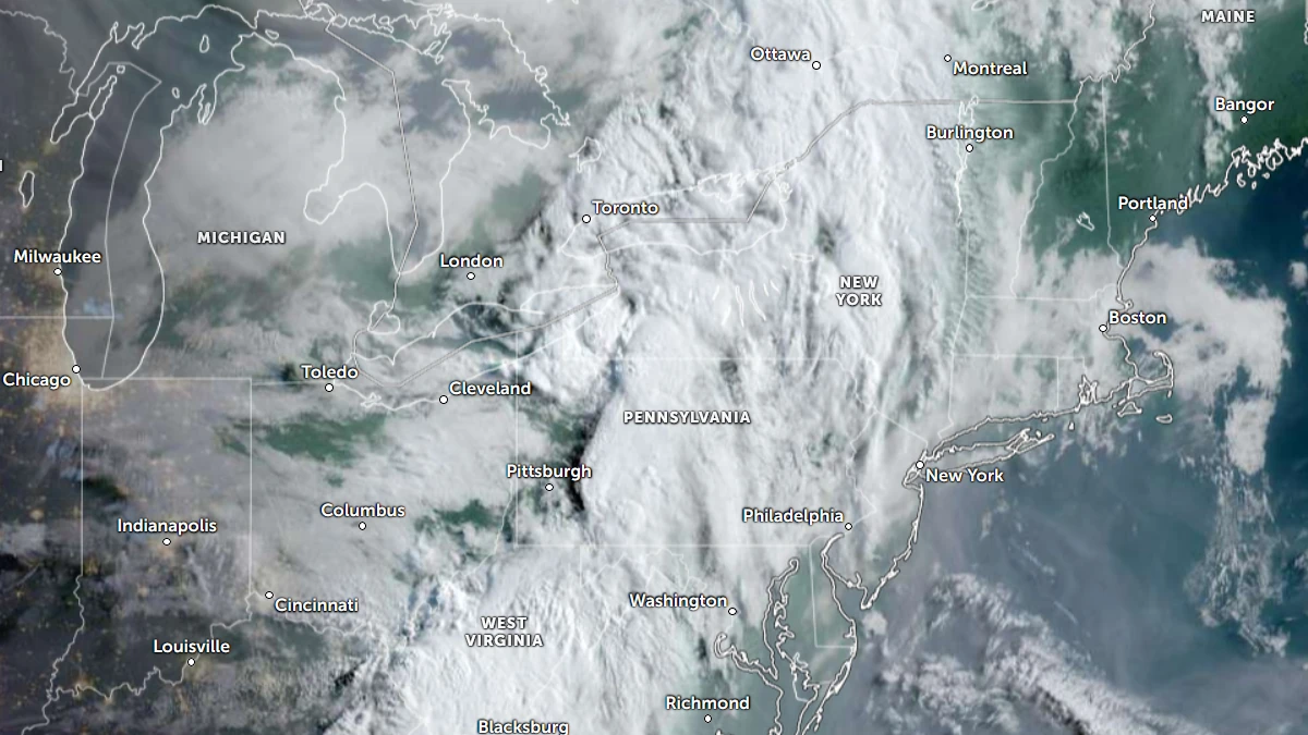
Satellite image of Northeast USA at 11:50 UTC on July 28, 2026. Credit: NOAA/GOES-19, Zoom Earth, The Watchers
A Moderate Risk of excessive rainfall is in effect for parts of New Jersey, New York, and Connecticut on Tuesday, July 28.
An unusually strong upper-level low developing over the Northeast will bring heavy rains and potentially significant flash flooding across parts of the Northeast, according to the National Weather Service’s Weather Prediction Center (WPC)
The greatest threat is expected across the tri-state region, where repeated thunderstorms capable of producing intense rainfall are forecast through Tuesday night.
The WPC expects a closed upper-level low to deepen over upstate New York before moving southeast into New England. As the system strengthens, it will increase lift across the atmosphere while drawing additional moisture northward. Combined with strong upper-level dynamics, these conditions will support widespread thunderstorm development from the Mid-Atlantic into southern New England.
Forecasters expect atmospheric moisture to be unusually high for late July. Precipitable water values around 44 mm (1.75 inches) will combine with most-unstable CAPE of 2 000 to 3 000 J/kg, creating an environment favorable for very heavy rainfall. The combination of abundant moisture, strong instability, and persistent lift will allow thunderstorms to produce intense rainfall over the same locations.
High-resolution forecast models continue to show a threat of training thunderstorms. The WPC said there is a 15 to 25% chance of rainfall rates reaching 51 mm (2 inches) per hour.
Repeated thunderstorm development along the approaching front, increasing the risk of flash flooding, especially in urban areas and places with poor drainage.
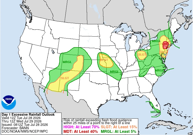
Elsewhere, scattered monsoon thunderstorms are expected across the Four Corners states and parts of the central High Plains as deep moisture combines with afternoon heating. Storms will likely develop first over higher terrain before moving into lower elevations, especially in New Mexico and Colorado. Some storms are expected to move slowly, increasing the risk of localized flash flooding.
Meanwhile, a disturbance moving south along the peninsula will interact with very moist and unstable air across the western Florida Peninsula and the Florida Keys.
Precipitable water values of 51 to 57 mm (2 to 2.25 inches) and weak steering winds will allow thunderstorms to repeatedly develop over the eastern Gulf of Mexico and move into parts of South Florida and the Keys. Rainfall totals of 51 to 102 mm (2 to 4 inches) are expected, with locally higher amounts possible where storms repeatedly track over the same areas.
Another flash flood threat exists across parts of the Missouri Valley. Thunderstorms from overnight are expected to weaken before another round develops later Tuesday into Tuesday night as a disturbance moves along a frontal boundary.
Strengthening low-level winds will transport warm, humid air northward, supporting organized clusters of thunderstorms capable of producing rainfall rates of 25 to 51 mm (1 to 2 inches) per hour. Where storms repeatedly move over the same locations, rainfall totals of 51 to 102 mm (2 to 4 inches) could produce flash flooding.
References:
1 Day 1 Excessive Rainfall Outlook – NWS/WPC – July 28, 2026

I am an Assistant Editor and Severe Weather & Science Journalist at The Watchers, specializing in real-time severe weather coverage, geophysical event reporting, and research-driven scientific analysis. You can reach me at rishav(at)watchers(.)news.

Commenting rules and guidelines
We value the thoughts and opinions of our readers and welcome healthy discussions on our website. In order to maintain a respectful and positive community, we ask that all commenters follow these rules.