
Strong and shallow M7.1 earthquake hits Kyushu, Japan, hazardous tsunami waves possible
A strong and shallow earthquake registered by the USGS as M6.8 struck Kyushu, Japan at 07:27 UTC (16:27 JST) on July 28, 2026. The agency is reporting a depth of 10 km (6.2 miles). EMSC is reporting M6.8 at a depth of 10 km (6.2 miles), while the Japan Meteorological Agency (JMA) reported M7.1 at a depth of 10 km (6.2 miles) in the Kumamoto Region, Kumamoto Prefecture. According to the Pacific Tsunami Warning Center (PTWC), hazardous tsunami waves are possible within 300 km (186 miles) of the epicenter.
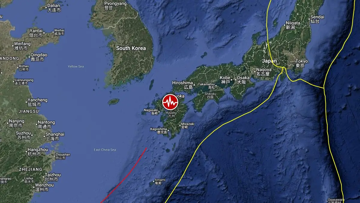
Epicenter of M6.8 earthquake in Kyushu, Japan on July 28, 2026. Credit: TW/SAM, Google
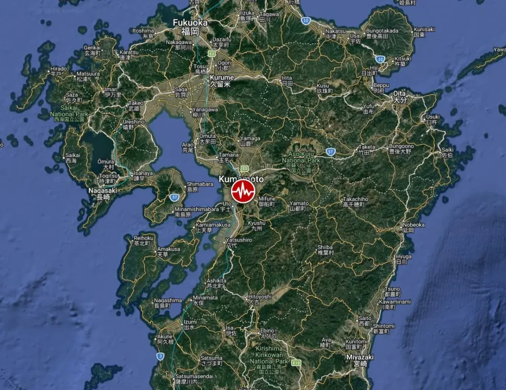
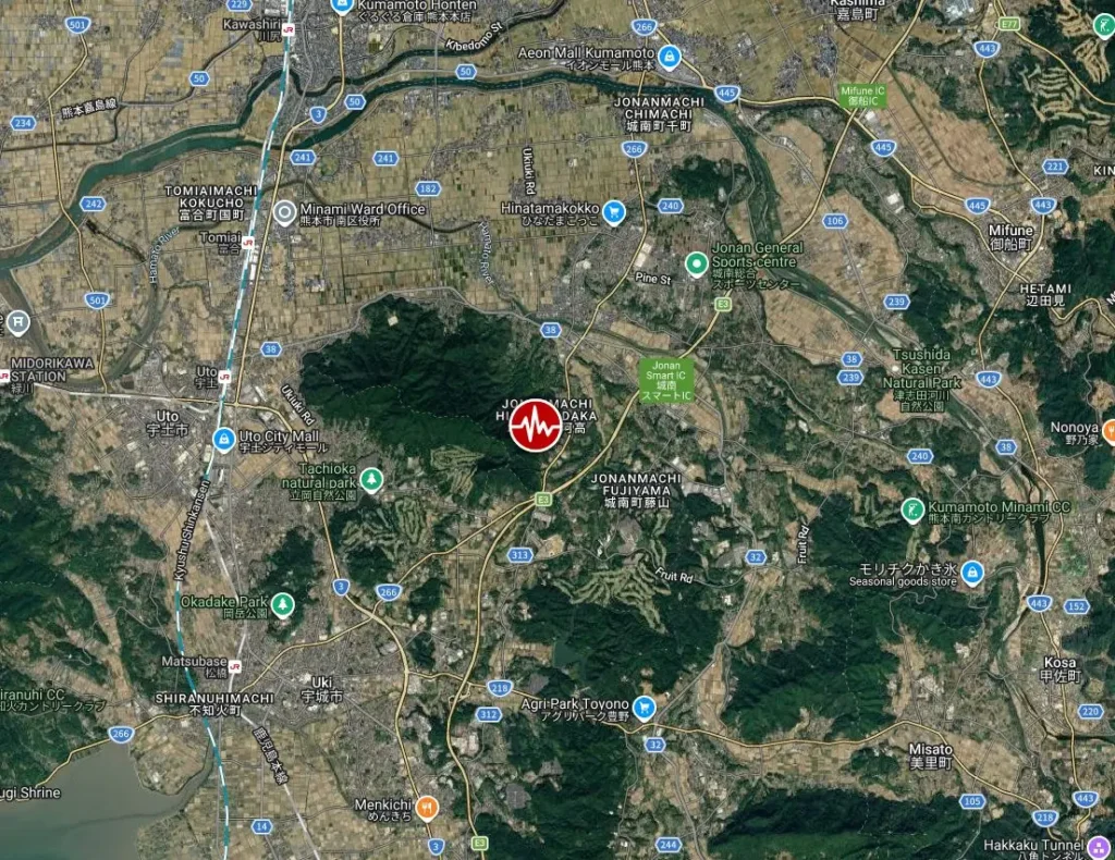
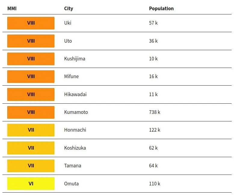
The epicenter was located 5.2 km (3.2 miles) E of Uto (population 37 442), 6.2 km (3.9 miles) NE of Matsubase (population 26 163), 8.7 km (5.4 miles) NE of Uki (population 59 928), 10.2 km (6.3 miles) WSW of Mifune (population 16 901), and 14.1 km (8.8 miles) SSE of Kumamoto (population 738 907), Japan.
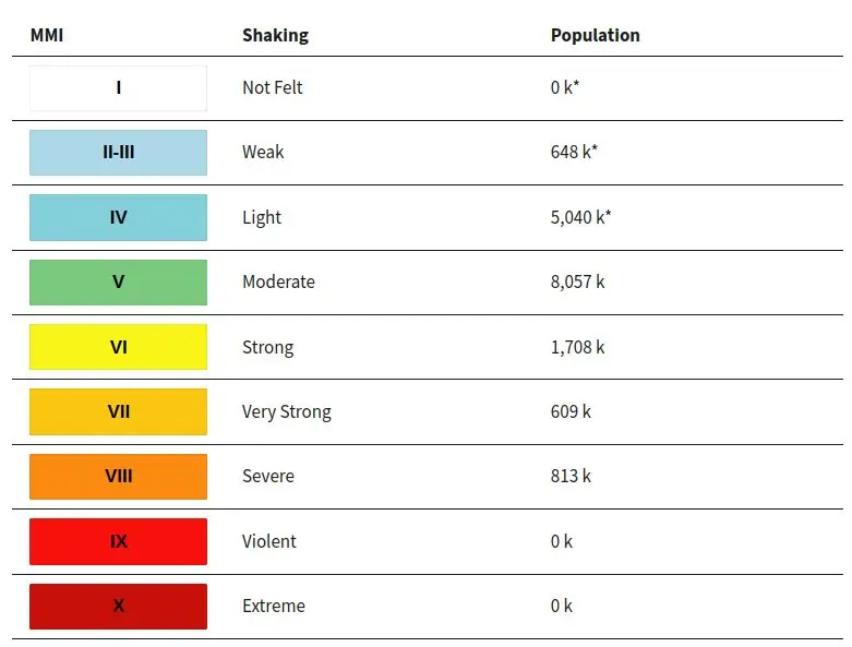
According to the USGS PAGER, 813 000 people are estimated to have felt severe shaking, 609 000 very strong, 1.7 million strong, and 8 million moderate.
According to the Pacific Tsunami Warning Center (PTWC), hazardous tsunami waves are possible within 300 km (186 miles) of the epicenter.
Overall, the population in this region resides in structures that are resistant to earthquake shaking, though vulnerable structures exist. The predominant vulnerable building types are heavy wood frame and reinforced/confined masonry construction.
Recent earthquakes in this area have caused secondary hazards such as landslides that might have contributed to losses.
Liquefaction triggered by this earthquake is estimated to be significant in severity and/or spatial extent, according to the USGS. The number of people living near areas that could have produced liquefaction in this earthquake is extensive.
Landslides triggered by the earthquake are expected to be significant in severity and/or spatial extent, with a significant population exposed.
Updates
05:31 UTC, July 29
Three people had been officially reported killed and 23 as injured. Eight additional deaths remained under investigation, while search and rescue operations continued at collapsed commercial, industrial and residential structures.
The Fire and Disaster Management Agency listed three disaster-related deaths, eight serious injuries and 15 minor injuries. The agency recorded eight other deaths separately because their medical classification or relationship to the earthquake had not been completed. Additional injury reports were also awaiting assessment, and the casualty figures remained preliminary.
JMA intensity 7 was recorded in Uki City and Hikawa Town. Intensity 6+ affected Kumamoto, Yatsushiro and Uto cities, Misato Town and Mashiki Town, while intensity 6- was recorded in Kamiamakusa and Koshi cities and the towns of Ozu, Nishihara, Mifune and Ashikita.
Authorities recorded 54 rescue incidents by 14:00 JST on July 29. The main operations remained concentrated at the partially collapsed Aeon Mall Kumamoto in Kashima Town, a collapsed chimney at the Nippon Paper Industries mill in Yatsushiro City and two damaged or collapsed homes in Hikawa Town.
Part of the second floor of Aeon Mall Kumamoto collapsed during the earthquake. Kumamoto Prefecture reported that eight people had been removed during the earlier stages of the operation, including two reported dead, one in cardiopulmonary arrest, four with moderate injuries and one with a minor injury. Rescue work continued after that report, and the figures did not represent the final outcome at the site.
A chimney collapsed at the Nippon Paper Industries facility in Yatsushiro City. Eleven people were initially reported trapped. Four had been removed during the early response, including two people in cardiopulmonary arrest and two with serious injuries, while the status of the remaining workers was still being investigated at the time of the prefectural report.
Emergency teams were also operating at two buckled or collapsed homes in Hikawa Town. Emergency Fire Response Teams from Oita Prefecture were assigned to the incidents.
Nine earthquake-related fires were reported, and all had been extinguished by the latest FDMA update. Emergency Fire Response Teams were deployed from nine prefectures. Approximately 1 410 firefighters and rescue personnel, including local, prefectural and outside units, were operating in the affected region by 13:00 JST.
FDMA reported Emergency Safety Assurance instructions affecting 92 743 people and evacuation orders affecting 222 250 people. Kumamoto Prefecture reported 9 872 people staying at 465 shelters at 07:30 JST.
Approximately 84 000 households remained without water across two prefectures and 11 municipalities at 12:00 JST. The largest outages affected approximately 20 000 households in Kumamoto City, 18 000 in Yatsushiro City, 14 000 in Uki City, 10 500 in Hikawa Town, 10 000 in Uto City and 8 220 in Kamiamakusa City. Ruptured and leaking pipes were responsible for many of the disruptions.
The Japan Water Works Association and national authorities were coordinating additional vehicles and personnel.
Kumamoto Prefecture reported approximately 36 700 households without electricity at 07:30 JST. Power, water, gas or structural problems were also reported at medical institutions, pharmacies, elderly-care facilities, child-welfare facilities and disability-support facilities. Emergency power vehicles were being arranged for affected medical sites.
Seventeen sections of three expressways remained closed, including 10 sections of the Kyushu Expressway, six sections of the Minami-Kyushu Expressway and one section of the Kyushu Chuo Expressway. Bridge damage also closed sections of national routes 57, 218, 219 and 266.
Fourteen sections of prefectural roads were closed across Kumamoto, Oita and Miyazaki prefectures because of rockfalls, surface deformation, bridge damage and slope failures. The pedestrian section of Ueyana Bridge in Yatsushiro City collapsed, although the vehicle lanes remained passable.
A slope failure isolated the Mezaru district of Yamato Town, affecting four households and six residents. Pedestrian access remained possible, and essential services were available.
The entire Kyushu Shinkansen remained suspended. Inspections identified a severed overhead power line at Kumamoto Station, track deformation at the Kumamoto Shinkansen depot and additional track deformation between Matsubase and Ogawa. Four operators had service suspended on six conventional railway lines.
Kumamoto Airport reopened its runway after inspections. Twenty-nine flights were canceled on July 28, with another 14 cancellations scheduled for July 29. Nine highway-bus operators suspended 27 routes, while three local bus operators also reported service interruptions.
Liquefaction, settlement and ground depressions damaged parts of Yatsushiro Port, including the container-terminal area. A 40 m (131 feet) section behind an earthquake-resistant quay developed vertical displacement. Emergency repairs covered 20 m (66 feet), and authorities judged the berth usable.
At Kumamoto Port, a ferry loading bridge was struck by a violently moving moored vessel and became unusable. A gantry crane was damaged, and cracks developed along a port road. Liquefaction also affected Eco Park Minamata at Minamata Port, which was closed to entry. Cracks were reported at Misumi and Tanoura ports.
Authorities attributed the port damage to earthquake shaking, liquefaction and ground deformation. No verified tsunami damage was identified.
JMA issued a tsunami advisory for the Ariake Sea and Yatsushiro Sea at 16:29 JST (07:29 UTC), two minutes after the mainshock. The advisory was lifted at 18:10 JST (09:10 UTC) on July 28, and no renewed tsunami advisory had been issued in the latest reviewed reports.
No verified tsunami inundation, damaging tsunami wave or tsunami-related casualty was identified. Authorities reported no confirmed damage to coastal defenses, although inspections remained incomplete along parts of the Kumamoto, Nagasaki and Kagoshima coasts.
By 12:00 JST on July 29, authorities recorded 48 earthquakes reaching JMA intensity 3 or higher. These included the intensity-7 mainshock, three intensity-5- earthquakes, 11 intensity-4 earthquakes and 33 intensity-3 earthquakes.
JMA warned that another earthquake producing severe shaking remained possible for approximately one week, with the first two to three days requiring particular attention. Damaged buildings, weakened slopes, disrupted roads and continuing utility failures remained the main secondary concerns.
Estimated population exposure to earthquake shaking
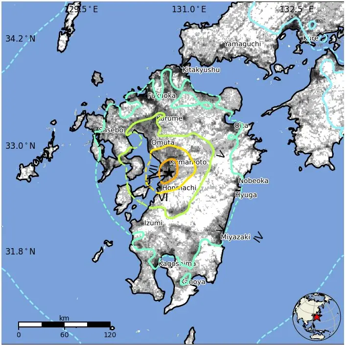
Selected cities exposed
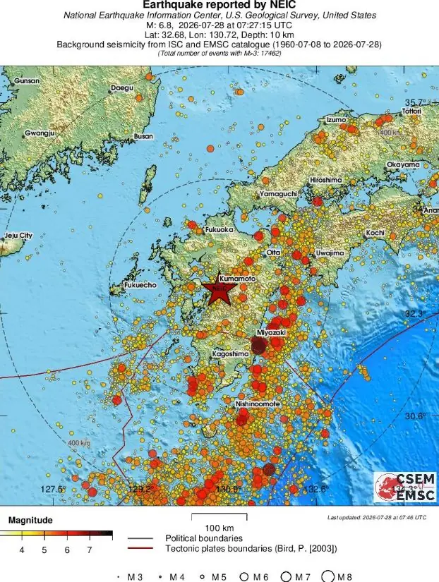
Regional seismicity
References:
1 M6.8 earthquake Kyushu, Japan – USGS – July 28, 2026
2 M6.8 earthquake Kyushu, Japan – EMSC – July 28, 2026
3 M6.8 earthquake Kyushu, Japan – PTWC – July 28, 2026

Teo Blašković founded The Watchers in 2011 and edited it until 2026, covering seismic and volcanic activity, extreme weather, space weather and near-Earth objects. Articles on this page are his archive.
Published in the last 24 hours
- Hawaii's largest freshwater lake was 200 feet deep at 10 a.m. on June 2, 2018. By that afternoon, lava from Kilauea had boiled it away Epicenter
- Flying glass cut a teacher in Russia but none of her 44 pupils, because when a meteor flashed across the sky in 2013, she told them to get under their desks Epicenter
- A South Dakota man put the widest and heaviest hailstone on US record in his freezer, and a power cut melted part of it before NOAA measured it at 8 inches across and nearly 2 pounds in 2010 Epicenter
- Black kites and brown falcons in northern Australia have been seen snatching smoldering sticks from wildfires, flying them into unburned grass and dropping them, starting new fires that send lizards, rodents and insects running straight toward the waiting birds Epicenter
