
Tropical Cyclone “Rusty” to become Category 4 system – extremely heavy rainfall on West Australian coast
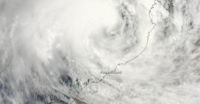
Image credit: TC Rusty, February 25, 2013 - NASA Terra Satellite
Tropical Cyclone Rusty is bringing extremely heavy rainfall and very dangerous winds to a vast swathe of the West Australian coast. Pardoo, Whim Creek, Port Hedland and South Hedland are on red alert. Streets are now empty and people urged to stay in shelters. Australian Bureau of Meteorology warned that very destructive winds of up to 165 km/h between Whim Creek and Pardoo are possible on Wednesday, February 27, 2013.
Slow motion and large size of Rusty means very destructive winds will hit the WA coast well before the eye of the storm. Wind gusts of 120km/h have already hit Port Hedland and gale force winds will rip along the coast between Sandfire Roadhouse and Whim Creek, with the destructive winds extending from near Port Hedland to around Wallal.
The Bureau has issued a cyclone warning for coastal areas from Bidyadanga to Mardie including Port Hedland, Karratha and Dampier and adjacent inland areas of the Pilbara, including Marble Bar, Nullagine and Millstream.
 TC Rusty – multispectral satellite image – February 26, 2013 at 05:32 UTC
On February 26, 2013 (09:00 UTC) JTWC reported that TC Rusty was located approximately 335 NM east-northeast of Learmonth, Australia (19.5S, 119.2E) and has tracked south-southwestward. Animated multispectral satellite imagery showed the system has maintained a ragged eye even as convective bands began to slightly unwind.
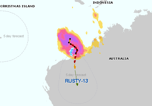
 TC Rusty – tracking map – February 26, 2013
The State Emergency Service says communities between Pardoo and Whim Creek, including Port Hedland and South Hedland are on a red alert. A yellow alert has been extended inland to include Marble Bar as well as communities between Wallal and Pardoo.
Bureau of Meteorology predicts the system to intensify to a Category 4 system, equal to Cyclone Tracy which obliterated Darwin, in the next 24 hours before the eye of the storm crosses the coast tomorrow.
 Rain map with eTraP data. (Source: JRC)
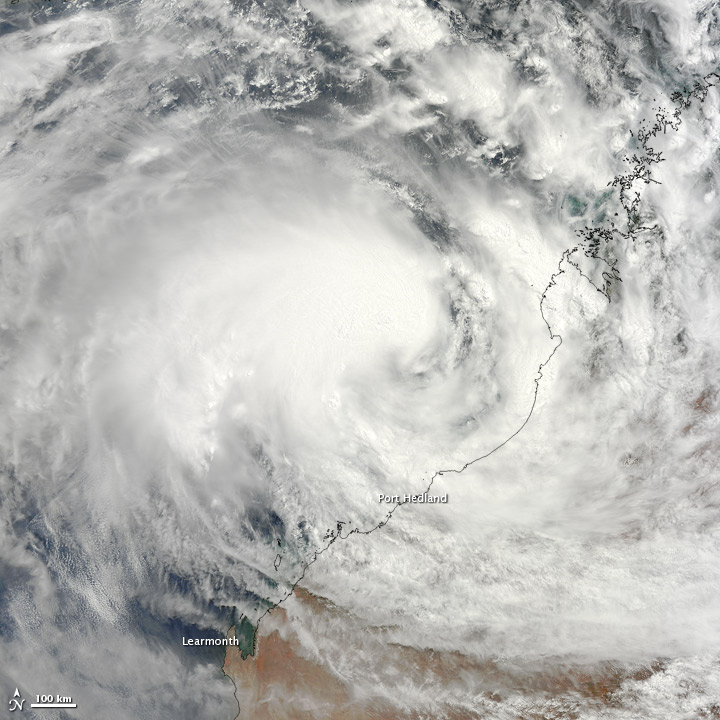 TC Rusty – NASA Terra Satellite – On February 25, 2013, Tropical Cyclone Rusty was bearing down on the northwestern coast of Australia. The Moderate Resolution Imaging Spectroradiometer (MODIS) on NASA’s Terra satellite captured this natural-color image the same day. Although Rusty lacked a distinct eye, the storm sported the spiral shape characteristic of strong storms.
- More images here.
I'm a dedicated researcher, journalist, and editor at The Watchers. With over 20 years of experience in the media industry, I specialize in hard science news, focusing on extreme weather, seismic and volcanic activity, space weather, and astronomy, including near-Earth objects and planetary defense strategies. You can reach me at teo /at/ watchers.news.
Commenting rules and guidelines
We value the thoughts and opinions of our readers and welcome healthy discussions on our website. In order to maintain a respectful and positive community, we ask that all commenters follow these rules.