
Rapidly intensifying winter storm to strike Ontario with snow, ice, and high winds
A powerful bomb cyclone is forecast to strike Ontario bringing heavy snow, freezing rain, and severe winds from Sunday through Tuesday, December 28 to 30, 2025, as the deepening low crosses the Great Lakes. Environment and Climate Change Canada has issued Winter Storm and Freezing Rain Warnings, with snowfall totals of up to 50 cm (20 inches) and gusts exceeding 100 km/h (62 mph) expected in some areas.
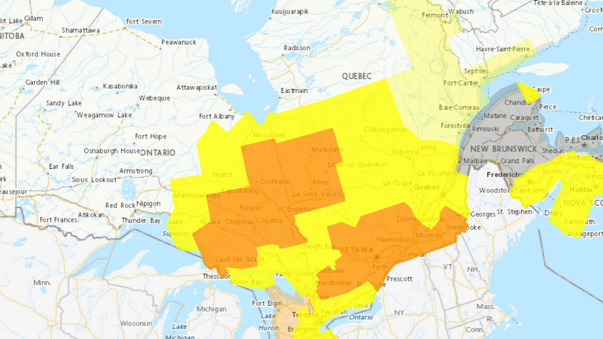
Map of orange and yellow alerts across Ontario as of December 28, 2025. Credit: ECCC
A powerful winter storm is forecast to track northeast across the Great Lakes between Monday and Tuesday. The storm will bring a mix of heavy snow, freezing rain, strong winds, and heavy rainfall across much of Ontario through Tuesday.
The system is forecast to undergo rapid cyclogenesis over the U.S. Midwest, with surface pressure expected to drop more than 24 hPa in 24 hours as the low moves into the Great Lakes basin. The minimum central pressure of the system is forecast to drop to around 975 hPa at the storm’s peak.
Environment and Climate Change Canada (ECCC) issued Winter Storm Warnings, Snowfall Warnings, and Freezing Rain Warnings for large parts of the province. Additional Rainfall Warnings and Wind Warnings are expected as the system develops.
Northern and northeastern Ontario, including Timmins, Chapleau, Wawa, and Cochrane, are forecast to receive 30–50 cm (12–20 inches) of snow, with localized totals possibly exceeding 50 cm (20 inches). Blizzard conditions are likely where winds exceed 70 km/h (43 mph), producing whiteouts and near-zero visibility.
Eastern Ontario, including Ottawa and surrounding areas, is under a Freezing Rain Warning with the potential for 10–15 mm (0.4–0.6 inches) of ice accretion. The combination of ice load and wind gusts near 80 km/h (50 mph) could lead to tree damage and extended power outages.
The system will initially bring heavy rainfall of 30–50 mm (1.2–2 inches) across Southern Ontario, with locally higher totals near the Golden Horseshoe and Lake Erie shorelines.
Temperatures are forecast to drop sharply behind the cold front, triggering flash freeze and widespread icy road surfaces. Rainfall and Wind Warnings are anticipated for these regions.
Sustained winds of 60–90 km/h (35–55 mph), with gusts up to 110 km/h (70 mph) near exposed shorelines of Lake Erie and Georgian Bay, will enhance blowing snow hazards and the risk of power interruptions.
Hydro One has activated its storm response plan and is advising residents to prepare for potential outages through December 30.
The Ontario Provincial Police (OPP) and local municipalities are warning against non-essential travel during the height of the storm, particularly from late Sunday evening through Monday.
Air and ground transportation disruptions are expected, with possible flight cancellations and highway closures due to visibility below 400 m (1 300 feet) in blizzard-prone areas.
Snow squalls are expected to persist into December 30 as cold air moves over the Great Lakes, producing additional localized accumulations. Temperatures will remain below −10°C (14°F) in northern Ontario by Tuesday morning, with wind chills near −20°C (−4°F).
Read more:

I am an Assistant Editor and Severe Weather & Science Journalist at The Watchers, specializing in real-time severe weather coverage, geophysical event reporting, and research-driven scientific analysis. You can reach me at rishav(at)watchers(.)news.
Commenting rules and guidelines
We value the thoughts and opinions of our readers and welcome healthy discussions on our website. In order to maintain a respectful and positive community, we ask that all commenters follow these rules.