
Tropical Cyclone Errol weakens ahead of landfall over west Kimberley coast, Australia
Severe Tropical Cyclone Errol weakened to Category 3 strength on Thursday, April 17, 2025, after having rapidly intensified to a Category 5-equivalent system on April 16 — the first such tropical cyclone of the year globally. The system continues to weaken as it approaches the west Kimberley coast, Australia.

Satellite image of Tropical Cyclone Errol at 12:40 UTC on April 17, 2025. Image credit: RAMMB/CIRA, Himawari-9, The Watchers
Tropical Cyclone Errol rapidly intensified into a Category 5-equivalent system on April 16, 2025, according to data from the Joint Typhoon Warning Center (JTWC). The cyclone reached 1-minute sustained winds of 260 km/h (160 mph) and a minimum central pressure of 919 hPa during its peak, marking the first Category 5-equivalent tropical cyclone of the year worldwide.
The storm intensified from tropical storm strength in approximately 18 hours, with its central pressure falling by 70 hPa during that period. This rate of intensification qualifies as explosive or rapid intensification, defined as a pressure drop of at least 42 hPa in 24 hours.
Errol’s intensity later decreased due to increasing vertical wind shear and the intrusion of dry air, leading to a weakening trend as it approached the coast of Western Australia.
The system is expected to further weaken to Category 1 intensity before approaching the tip of the Dampier Peninsula on the afternoon of April 18, 2025. It is forecast to drop below tropical cyclone strength before making landfall over the west Kimberley coast on Friday evening between Cape Leveque and Cockatoo Island, north of Derby.
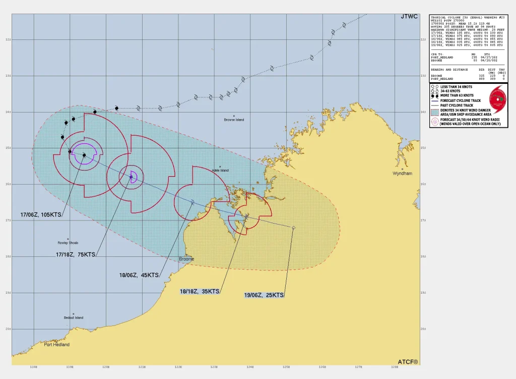
As of 14:00 AWST (06:00 UTC) on April 17, Errol was a Category 3 system with a minimum central pressure of 961 hPa. Maximum 10-minute sustained winds near the center were 155 km/h (96 mph), with 3-second gusts reaching 220 km/h (137 mph).
By 17:00 AWST (09:00 UTC), maximum sustained winds had decreased to 130 km/h (80 mph), with gusts reaching 185 km/h (115 mph).

Errol was located approximately 410 km (255 miles) northwest of Broome and 440 km (273 miles) west-northwest of Cockatoo Island, moving east-southeast at 10 km/h (6 mph). The system is forecast to continue in this direction until landfall on April 18.
Gales with damaging wind gusts are expected to develop between Cockatoo Island and Beagle Bay during the late morning of April 18, and may extend to Kuri Bay by Friday evening as Errol makes landfall.
Damaging wind gusts could extend southwards from Beagle Bay to Broome on April 18, if the cyclone’s track shifts south of the current forecast path.

Destructive wind gusts of up to 140 km/h (87 mph) are possible between Cockatoo Island and Beagle Bay on the afternoon of April 18, if Errol does not weaken as quickly as currently forecast.
Heavy rainfall may develop between Kuri Bay and Broome on April 18 and continue into the morning of April 19 as Errol approaches and crosses the west Kimberley coast. Tidal levels may rise above the normal high tide mark; however, sea levels are not expected to exceed the highest tide of the year.
Errol is the 11th named storm of the 2024/25 Australian region cyclone season. The season officially started on November 1, 2024, and will end on April 30.
References:
1 Tropical cyclone advice number 23 – BOM – April 17, 2025
2 Tropical cyclone technical bulletin – BOM – April 17, 2025

I am an Assistant Editor and Severe Weather & Science Journalist at The Watchers, specializing in real-time severe weather coverage, geophysical event reporting, and research-driven scientific analysis. You can reach me at rishav(at)watchers(.)news.
Commenting rules and guidelines
We value the thoughts and opinions of our readers and welcome healthy discussions on our website. In order to maintain a respectful and positive community, we ask that all commenters follow these rules.