
Hurricane “Irma” – Cuba to get hit, warnings extended northward along the Florida Peninsula
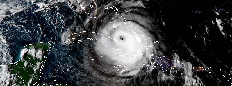
Featured image: Hurricane "Irma" at 22:45 UTC on September 8, 2017. Credit: NOAA/GOES-16 (preliminary and non-operational)
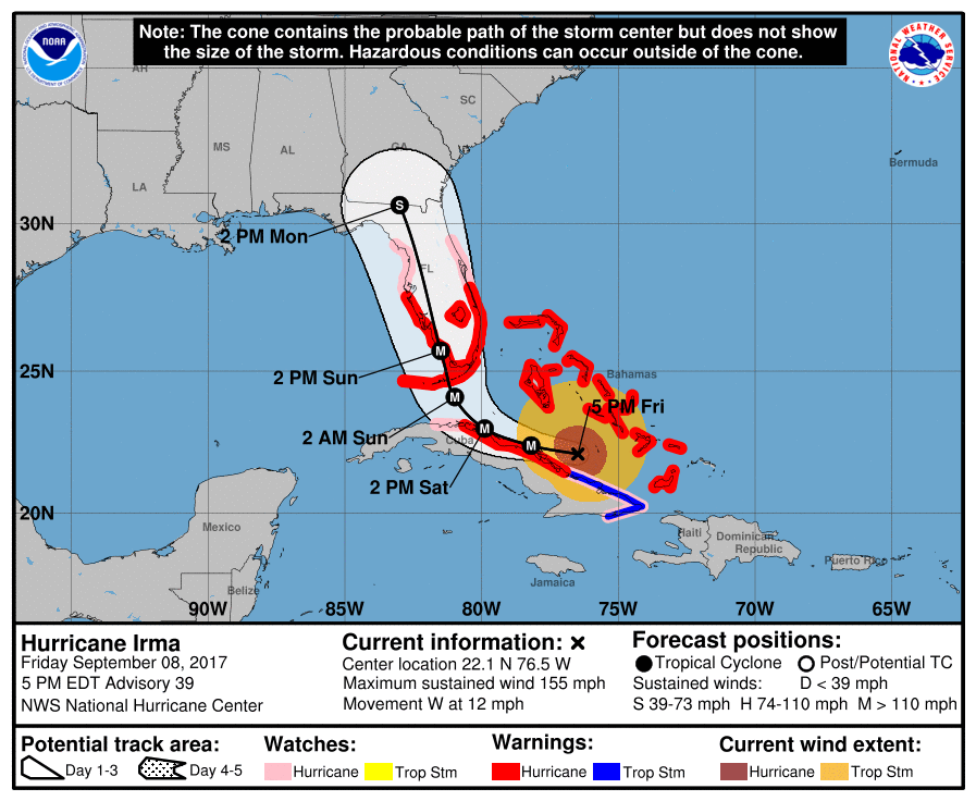
Hurricane "Irma" changed its projected path and its latest forecast track takes it over or very near the coast of northern Cuba. On the current forecast track, Irma will start moving away from Cuba around 18:00 UTC on Saturday, September 9 and make a turn toward Florida. Hurricane conditions are already spreading westward over portions of Cuba and the central Bahamas. Hurricane Warnings are extended northward along the Florida Peninsula.
After devastating everything in its path, Category 4 Hurricane "Irma" is now passing just north of eastern Cuba and, according to the latest forecast track, its deadly center is expected to pass directly over or very near the Jardines del Rey archipelago in northern Cuba.
Landfall is possible over the Cayo Romano island, in the province of Camagüey, before 12:00 UTC on Saturday, September 9. If it stays on this course, Irma will pass through the island of Cayo Coco, known for its all-inclusive resorts, and continue toward Cayo Santa Maria, Cayo Fragoso, and Cayos del Pajonal before making a turn toward Florida, United States, late Saturday (UTC) and early Sunday, September 10.
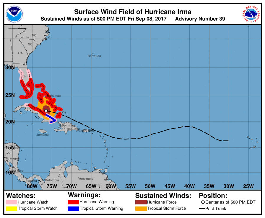
At 21:00 UTC on September 8, 2017, the center of Hurricane "Irma" was located about 310 km (195 miles) E of Caibarien, Cuba and 555 km (345 miles) SE of Miami, Florida. Its maximum sustained winds are 250 km/h (155 mph), making Irma a Category 4 hurricane on the Saffir-Simpson Hurricane Wind Scale.
Irma is moving west at 19 km/h (12 mph) with a minimum central pressure of 925 hPa and is expected to be near the Florida Keys and the southern Florida Peninsula Sunday morning (EDT).
Some fluctuations in intensity are likely to continue during the next day or two, and Irma is expected to remain a powerful Category 4 hurricane as it approaches Florida.
Hurricane-force winds extend outward up to 110 km (70 miles) from the center and tropical-storm-force winds extend outward up to 295 km (185 miles).
A Storm Surge Warning is in effect for:
- Sebastian Inlet southward around the Florida peninsula to Venice
- Florida Keys
A Storm Surge Warning means there is a danger of life-threatening inundation, from rising water moving inland from the coastline, during the next 36 hours in the indicated locations. This is a life-threatening situation. Persons located within these areas should take all necessary actions to protect life and property from rising water and the potential for other dangerous conditions. Promptly follow evacuation and other instructions from local officials.
A Storm Surge Watch is in effect for:
- North of Sebastian Inlet to the Flagler/Volusia County line
- North of Venice to Anclote River
- Tampa Bay
A Storm Surge Watch means there is a possibility of life-threatening inundation, from rising water moving inland from the coastline, in the indicated locations during the next 48 hours.
A Hurricane Warning is in effect for:
- Sebastian Inlet southward around the Florida peninsula to Anna Maria Island
- Florida Keys
- Lake Okeechobee
- Florida Bay
- Southeastern Bahamas
- Cuban provinces of Camaguey, Ciego de Avila, Sancti Spiritus, and Villa Clara
- Central Bahamas
- Northwestern Bahamas
A Hurricane Warning means that hurricane conditions are expected somewhere within the warning area. Preparations to protect life and property should be rushed to completion.
A Hurricane Watch is in effect for:
- North of Sebastian Inlet to the Flagler/Volusia County Line
- North of Anna Maria Island to the Suwannee River
- Cuban provinces of Guantanamo, Holguin, Las Tunas and Matanzas
A Hurricane Watch means that hurricane conditions are possible within the watch area. A watch is typically issued 48 hours before the anticipated first occurrence of tropical-storm-force winds, conditions that make outside preparations difficult or dangerous.
A Tropical Storm Warning is in effect for:
- Cuban provinces of Guantanamo, Holguin, and Las Tunas
A Tropical Storm Warning means that tropical storm conditions are expected somewhere within the warning area.
Hazards affecting land
The combination of a dangerous storm surge and the tide will cause normally dry areas near the coast to be flooded by rising waters moving inland from the shoreline. The water is expected to reach the following HEIGHTS ABOVE GROUND if the peak surge occurs at the time of high tide:
- SW Florida from Captiva to Cape Sable: 2.4 to 3.6 m (8 to 12 feet)
- Cape Sable to Boca Raton including the Florida Key: 1.5 to 3 m (5 to 10 feet)
- Venice to Captiva: 1.5 to 2.4 m (5 to 8 feet)
- Anclote River to Venice including Tampa Bay: 0.9 to 1.5 m (3 to 5 feet)
- Boca Raton to Flagler/Volusia County line: 0.9 to 1.8 m (3 to 6 feet)
The deepest water will occur along the immediate coast in areas of onshore winds, where the surge will be accompanied by large and destructive waves. Surge-related flooding depends on the relative timing of the surge and the tidal cycle, and can vary greatly over short distances.
The combination of a life-threatening storm surge and large breaking waves will raise water levels ABOVE NORMAL TIDE LEVELS by the following amounts within the hurricane warning area near and to the north of the center of Irma. Near the coast, the surge will be accompanied by large and destructive waves.
- Southeastern and central Bahamas: 4.5 to 6 m (15 to 20 feet)
- Northwestern Bahamas: 1.5 to 3 m (5 to 10 feet)
- Northern coast of Cuba in the warning area: 1.5 to 3 m (5 to 10 feet)
Hurricane conditions are still occurring in portions of the southeastern and Central Bahamas. Hurricane conditions are expected to continue within the hurricane warning area along the north coast of Cuba through Saturday. Hurricane conditions are expected in the northwestern Bahamas tonight and Saturday, and in portions of southern and central Florida and the Florida Keys Saturday night or early Sunday (EDT).
Hurricane conditions are possible within the watch area in central and north Florida by Sunday, with tropical storm conditions possible by late Saturday.
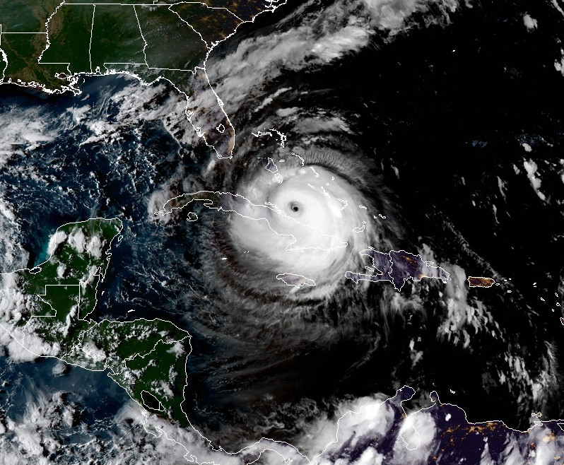
Hurricane "Irma" at 22:45 UTC on September 8, 2017. Credit: NOAA/GOES-16 (preliminary and non-operational)
Irma is expected to produce the following rain accumulations through Tuesday night:
- Dominican Republic, Haiti, and Turks and Caicos: additional 25.4 to 76.2 mm (1 to 3 inches).
- Southern Bahamas and northern Cuba: 254 to 381 mm (10 to 15 inches), isolated 508 mm (20 inches).
- Southern Cuba: 101.6 to 203.2 mm (4 to 8 inches), isolated 304.8 (12 inches).
- Jamaica: 25.4 to 50.8 mm (1 to 2 inches).
- The Florida Keys, much of the Florida peninsula, and southeast Georgia: 203.2 to 381 mm (8 to 15 inches), isolated 508 mm (20 inches).
- Western and Northern Florida peninsula from Tampa northward: 101.6 to 203.2 mm (4 to 8 inches), isolated 304.8 (12 inches).
- Rest of Eastern Georgia, western South Carolina, and Western North Carolina: 101.6 to 177.8 mm (4 to 7 inches).
- Western Georgia, eastern and northern Alabama, and southern Tennessee: 50.8 to 127 mm (2 to 5 inches).
In all areas this rainfall may cause life-threatening flash floods and, in some areas, mudslides.
A few tornadoes will be possible beginning Saturday morning across south Florida.
Swells generated by Irma are affecting the southeastern Bahamas, the Turks and Caicos Islands, the northern coast of the Dominican Republic, and should start affecting portions of the southeast coast of the United States tonight. These swells are likely to cause life-threatening surf and rip current conditions.
I'm a dedicated researcher, journalist, and editor at The Watchers. With over 20 years of experience in the media industry, I specialize in hard science news, focusing on extreme weather, seismic and volcanic activity, space weather, and astronomy, including near-Earth objects and planetary defense strategies. You can reach me at teo /at/ watchers.news.
Commenting rules and guidelines
We value the thoughts and opinions of our readers and welcome healthy discussions on our website. In order to maintain a respectful and positive community, we ask that all commenters follow these rules.