
High concentrations of Saharan dust affect Puerto Rico and U.S. Virgin Islands, moving west toward Florida and Texas
High concentrations of Saharan dust are affecting Puerto Rico and the U.S. Virgin Islands on June 26, 2026, reducing visibility and air quality as the Saharan Air Layer (SAL) moves west. Drier Saharan air is forecast to reach South Florida from late Saturday, June 27, followed by a dust plume over Southeast Texas late Sunday, June 28, where hazy skies and reduced air quality are possible.
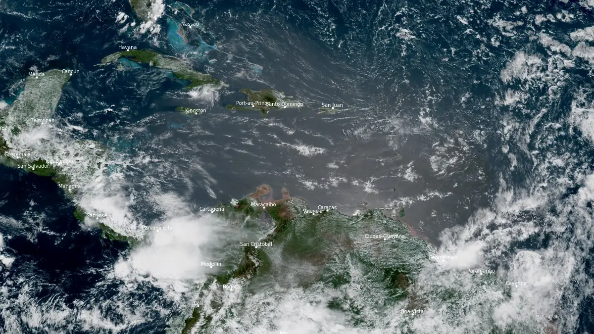
Saharan Air Layer (SAL) over the Caribbean Sea at 15:20 UTC on June 26, 2026. Credit: NOAA/GOES-East, RAMMB/CIRA, The Watchers
Meteorologists at the National Weather Service (NWS) office in San Juan, Puerto Rico, said high concentrations of Saharan dust are expected to persist over Puerto Rico and the U.S. Virgin Islands through late Friday afternoon, June 26.
Conditions are forecast to improve first over the Virgin Islands and then across Puerto Rico as the SAL progresses westward through the course of the day. Moderate concentrations are expected Friday night and low concentrations by early Saturday.
Hazy skies, reduced visibility, and deteriorated air quality are expected across the islands during the dust episode. NWS San Juan advised people in sensitive groups, including those with respiratory conditions, young children, and older adults, to limit prolonged outdoor exposure.
While the dry air mass is expected to suppress most shower activity, isolated afternoon showers remained possible over interior, western, and southwestern Puerto Rico.
A surface trough is forecast to cross the northeastern Caribbean on Saturday, bringing more normal moisture and a renewed chance of showers and isolated thunderstorms after the current dust episode moves out of the area.
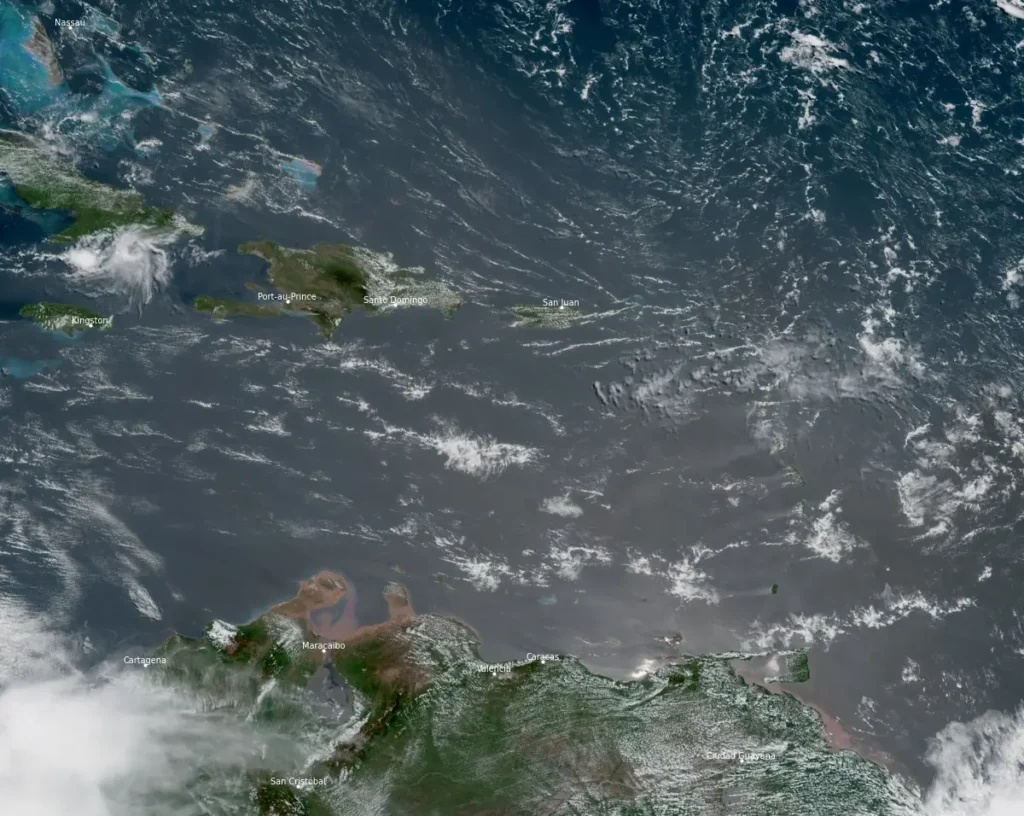
In South Florida, NWS Miami forecasts drier air associated with the SAL to begin moving into the region late Saturday, June 27.
Model guidance places the dust layer over the area on Sunday, but the office said its local weather effects remain uncertain. Afternoon thunderstorm chances remain in the forecast, with probabilities of 20–40% over eastern South Florida and 60–75% over interior and western areas.
NWS Houston/Galveston forecasts a Saharan dust plume to enter Southeast Texas late Sunday, June 28, and persist through late Tuesday, June 30. The plume may bring hazy skies and reduced air quality as well as more vivid sunrises and sunsets.
SAL is one of several factors forecasters watch across the tropical Atlantic during early hurricane season. Its warm, dry air and stronger mid-level winds can suppress thunderstorms and increase vertical wind shear, conditions that are unfavorable for tropical cyclone formation.
In its Tropical Weather Outlook issued at 12:00 UTC (08:00 EDT) on June 26, the National Hurricane Center said tropical cyclone formation was not expected across the North Atlantic, Caribbean Sea or Gulf of America during the following seven days.
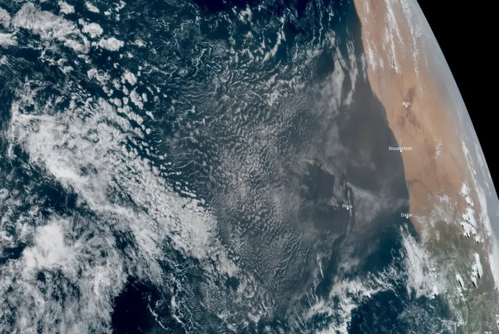
Satellite imagery acquired at 15:20 UTC on June 26 shows a fresh Saharan dust plume spreading west from the West African coast between Mauritania and Senegal into the eastern tropical Atlantic.
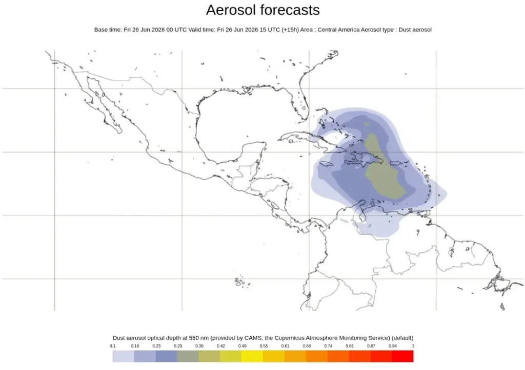
Copernicus Atmosphere Monitoring Service forecast initialized at 00:00 UTC on June 26 shows the leading aerosol signal advancing toward the eastern Caribbean by 00:00 UTC on June 30, while the denser core remains farther east over the Atlantic.
References:
1 Area Forecast Discussion – NWS/San Juan PR – June 26, 2026
2 Area Forecast Discussion – NWS/Miami FL – June 26, 2026
I'm a dedicated researcher, journalist, and editor at The Watchers. With over 20 years of experience in the media industry, I specialize in hard science news, focusing on extreme weather, seismic and volcanic activity, space weather, and astronomy, including near-Earth objects and planetary defense strategies. You can reach me at teo /at/ watchers.news.
Commenting rules and guidelines
We value the thoughts and opinions of our readers and welcome healthy discussions on our website. In order to maintain a respectful and positive community, we ask that all commenters follow these rules.