
Massive Saharan dust plume making its way over the Atlantic

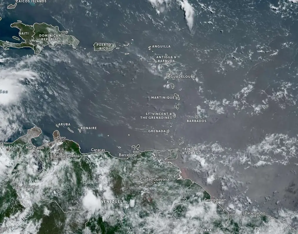
Featured image: Image credit: NOAA/GOES-East, Zoom Earth, The Watchers. Acquired at 14:20 UTC on June 26, 2024
The largest outbreak of Saharan dust this summer is currently making its way across the Atlantic Ocean, potentially impacting air quality and weather patterns throughout the Caribbean and parts of the United States. This marks a significant shift in the season’s weather patterns, influenced by the Saharan Air Layer (SAL), which is known for its ability to suppress tropical cyclone formation.
The current Saharan dust plume is the largest of the 2024 hurricane season, with its effects already observable in various regions.
The warm, dry, and windy conditions associated with the dust clouds are expected to continue suppressing tropical cyclone activity, providing a temporary respite from storm formation.
However, it remains to be seen whether this round of aerosols will reach the Lower 48 states, as early models from NASA and the European Union’s Copernicus program suggest that the dust may not traverse the entire Atlantic basin.
Saharan dust, composed of sand and mineral particles from the Sahara Desert, is transported across vast distances by high-altitude winds. This phenomenon is not unusual for this time of year.
“These plumes are common in the Atlantic basin at this time of year, typically peaking in late June and early July with a proclivity to spoil tropical development by stealing moisture from the air,” said Michael Lowry, Hurricane Specialist and Storm Surge Expert at WPLG-TV, ABC Miami, Florida.
A huge transport of #Saharandust is moving through #Atlantic.
— ADAM Platform (@PlatformAdam) June 25, 2024
As forecasted by @CopernicusECMWF the plume from #Africa is crossing the Ocean heading to #Caribbean. The #Copernicus #Sentinel5p map captured the long journey on June 24. #Airquality@TTWeatherCenter @Giulio_Firenze pic.twitter.com/jb6zfdg94K
#SaharanDust bringing high surface concentrations of PM10 across the Lesser Antilles today and continuing across the #Caribbean during the coming days in the #CopernicusAtmosphere forecast from 25 June 00 UTC. Latest charts at https://t.co/KZdmhRnNTD @CopernicusECMWF @ECMWF https://t.co/oOJNgdhTFO pic.twitter.com/7EbUros00J
— Mark Parrington (@m_parrington) June 25, 2024
The National Oceanic and Atmospheric Administration (NOAA) describes the SAL as having about 50% less moisture than the typical tropical atmosphere. This dry air, combined with strong winds and warm temperatures, can significantly impact tropical weather systems.
The extremely dry air can weaken tropical cyclones by promoting downdrafts around the storm. Additionally, the African Easterly Jet, with winds ranging from 40 to 88 km/h (25 to 55 mph), increases vertical wind shear, disrupting the internal structure of tropical cyclones. The warmth of the SAL stabilizes the atmosphere, suppressing cloud formation and maintaining its temperature as it travels across the ocean.
While models have waffled some on which feature may be the one to develop, they agree the environment will be ripe for formation this weekend into early next week.
— Michael Lowry (@MichaelRLowry) June 26, 2024
I discuss a growing tropical threat to the easternmost Caribbean in today's newsletterhttps://t.co/KnPAIRgQ5G pic.twitter.com/1c1upEpgTP
This year’s plume of Saharan dust began its moving over the Sahara Desert during the late spring, and as weather patterns transitioned to summer, the dust moved westward into the Atlantic basin.
The latest outbreak is expected to hold disturbances in the Main Development Region (MDR) in check for at least a week, possibly longer, limiting the formation of tropical cyclones.
Throughout the spring, major cities in Europe, including Rome, Paris, Athens, and Kyiv, experienced reduced visibility and poor air quality due to northward-traveling dust plumes.
As these patterns shifted, the dust is now headed towards the Caribbean and potentially the Gulf of Mexico. Coastal communities along the Florida Peninsula and the Gulf Coast are familiar with these summer dust plumes, which can impact air quality, produce colorful sunrises and sunsets, and reduce precipitation chances.
Islands in the Caribbean are particularly likely to see significant impacts from this dust plume, as enough particles will reach near the surface. According to forecasts, the dust is expected to enter the Caribbean and Gulf of Mexico this week and weekend, with varying degrees of impact on air quality and weather conditions.
Saharan dust has both positive and negative effects. On the beneficial side, it contributes to vibrant sunrises and sunsets and transports nutrients like iron across the ocean, enriching soil in areas such as the Amazon rainforest. However, the dust can also pose health risks, particularly for individuals with respiratory issues like asthma. The particles can exacerbate respiratory conditions and negatively impact coral reefs, contributing to algae blooms.
NOAA mentions three key characteristics of Saharan dust outbreaks that influence tropical cyclones and the general climate of the Atlantic tropical atmosphere: extremely dry air, the African Easterly Jet, and warm temperatures. The dry air reduces moisture levels by 50%, weakening tropical disturbances. The strong winds of the African Easterly Jet increase vertical wind shear, disrupting storm formation. The warm temperatures stabilize the atmosphere, suppressing cloud development and maintaining the dust layer’s warmth as it travels.
The presence of Saharan dust enhances the view of sunrises and sunsets. The dust scatters sunlight in a unique way, leading to hazy white skies during the day and vibrant orange and red hues during sunsets. These colorful displays are most noticeable a few hours after sunrise and in the late afternoon.
References:
1 Massive plume of Saharan dust keeps tropics in check for now – FOX Weather – June 25, 2024
2 The Saharan Air Layer: What is it? Why does NOAA track it? – NOAA – June 24, 2020
3 The Saharan Air Layer – AOML – June 24, 2020
4 What is Saharan dust? A huge blob is in the Atlantic. What does it do for storms? – USA Today -June 24, 2024
5 Saharan dust might be coming our way. Why do we care? – NBC6 -June 25, 2024

I am an Assistant Editor and Severe Weather & Science Journalist at The Watchers, specializing in real-time severe weather coverage, geophysical event reporting, and research-driven scientific analysis. You can reach me at rishav(at)watchers(.)news.
These headlines are much appreciated. Living outside of Philly, we do not hear of ANY of these headlines.. zero. EVER. It is as if this state lives in a box. A self congradulatory box. I truly appreciate this kind of coverage, with vetted info. Keep up the good work and excellent coverage. It is more important than we can possibly imagine.