
Netherlands issues first-ever Code Red warning for extreme heat as temperatures approach 40°C (104°F)
The Royal Netherlands Meteorological Institute (KNMI) placed much of the Netherlands under its first-ever Code Red warning for extreme heat on Friday after forecasting oppressive conditions, heat stress levels of 9 to 10 and isolated highs reaching up to 40°C (104°F).
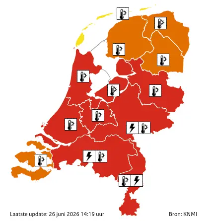
Netherlands red and orange heat alert map on June 26, 2026. Credit: KNMI
KNMI issued the country’s first-ever Code Red (Weeralarm) for extreme heat on Friday, June 26, placing much of the Netherlands under its highest weather warning.
Temperatures were forecast to locally reach 40°C (104°F). Code Orange remained in effect across the northern provinces and Zeeland, while the Wadden Islands were under Code Yellow.
The KNMI warned that the combination of exceptionally high temperatures and high humidity would create oppressive and uncomfortable conditions capable of causing dehydration, overheating, and heatstroke.
Afternoon heat stress values were forecast to reach 9 to 10, while the National Heat Plan issued by the National Institute for Public Health and the Environment (RIVM) remained in effect at least through Saturday.
“Today, code red applies in a large part of the Netherlands for extreme heat. In addition, heat force 10, the highest class, is also expected in parts of the country. Heat power shows how taxing the heat can be on your body. We not only look at the temperature, but also at the humidity, wind, and solar radiation,” KNMI said on June 26.
Friday’s forecast called for maximum temperatures of 33–36°C (91–97°F) across the north and west and 36–39°C (97–102°F) inland, with isolated locations possibly reaching 40°C (104°F). Along the coast, a developing sea breeze later in the afternoon and evening was expected to provide some relief.
The extreme heat is forecast to continue on Saturday, June 27, with maximum temperatures again reaching 33–36°C (91–97°F). The Code Red warning will remain in effect for Limburg, North Brabant, Gelderland, and Overijssel, while Code Orange will remain in force across the rest of the country, except for the Wadden Islands, which will remain under Code Yellow.
Nighttime conditions are also expected to remain exceptionally warm. Minimum temperatures of 20–23°C (68–73°F) are forecast during the nights into Saturday and Sunday, producing tropical nights across many areas. In urban locations, temperatures may remain between 23 and 25°C (73–77°F) overnight, limiting nighttime cooling and increasing cumulative heat stress.
Although temperatures in the Netherlands exceeded 40°C (104°F) during the July 2019 heatwave, this is the first occasion on which the country’s highest weather warning has been activated specifically for extreme heat.
The KNMI also warned of a growing risk of severe thunderstorms as the heatwave evolves. An isolated severe thunderstorm is possible over the southeast on Friday evening, where strong to severe wind gusts, hail, and heavy rainfall may occur under a Code Yellow warning.
On Saturday evening, the Code Yellow warning for severe thunderstorms is expected to expand nationwide, with large hail, damaging wind gusts, and heavy rainfall capable of causing localized disruption and damage.
It is worth noting that meteorologically, there is no difference between code orange and code red. The decision to escalate is taken by a weather impact team that includes the KNMI, police, the fire service, the national crisis center, and rail network manager ProRail, and is made when dangerous weather threatens to disrupt society.
“A lot of people wonder what the difference is between code orange and code yellow. When it’s hot, the meteorological guidelines for code orange and code red are the same. The difference is mainly in the expected impact,” KNMI said.
The heatwave is part of the larger event driven by a heat dome that broke multiple heat records across Europe over the last month and is expected to begin shifting east over the weekend. It has already claimed hundreds of lives, with 55 deaths being reported dead in France since June 18 and 212 in Spain from June 21 to 24.
References:
1 Liveblog heat and thunderstorms from June 22, 2026 – KNMI – June 26, 2026
2 WEATHER ALERT: Extreme heat in many places. Chance of thunderstorms as well, especially on Saturday evening – KNMI – June 26, 2026

I am an Assistant Editor and Severe Weather & Science Journalist at The Watchers, specializing in real-time severe weather coverage, geophysical event reporting, and research-driven scientific analysis. You can reach me at rishav(at)watchers(.)news.
Commenting rules and guidelines
We value the thoughts and opinions of our readers and welcome healthy discussions on our website. In order to maintain a respectful and positive community, we ask that all commenters follow these rules.