
Dense Saharan dust reaches Spain, France and Italy, reducing air quality and visibility
Thick Saharan dust from North Africa covered parts of Portugal, Spain, France, Italy, and neighboring countries on March 4, 2026, producing hazy skies, orange deposits, and moderate-to-poor air quality. Forecasts show the plume spreading toward central Europe before dispersing after March 6.
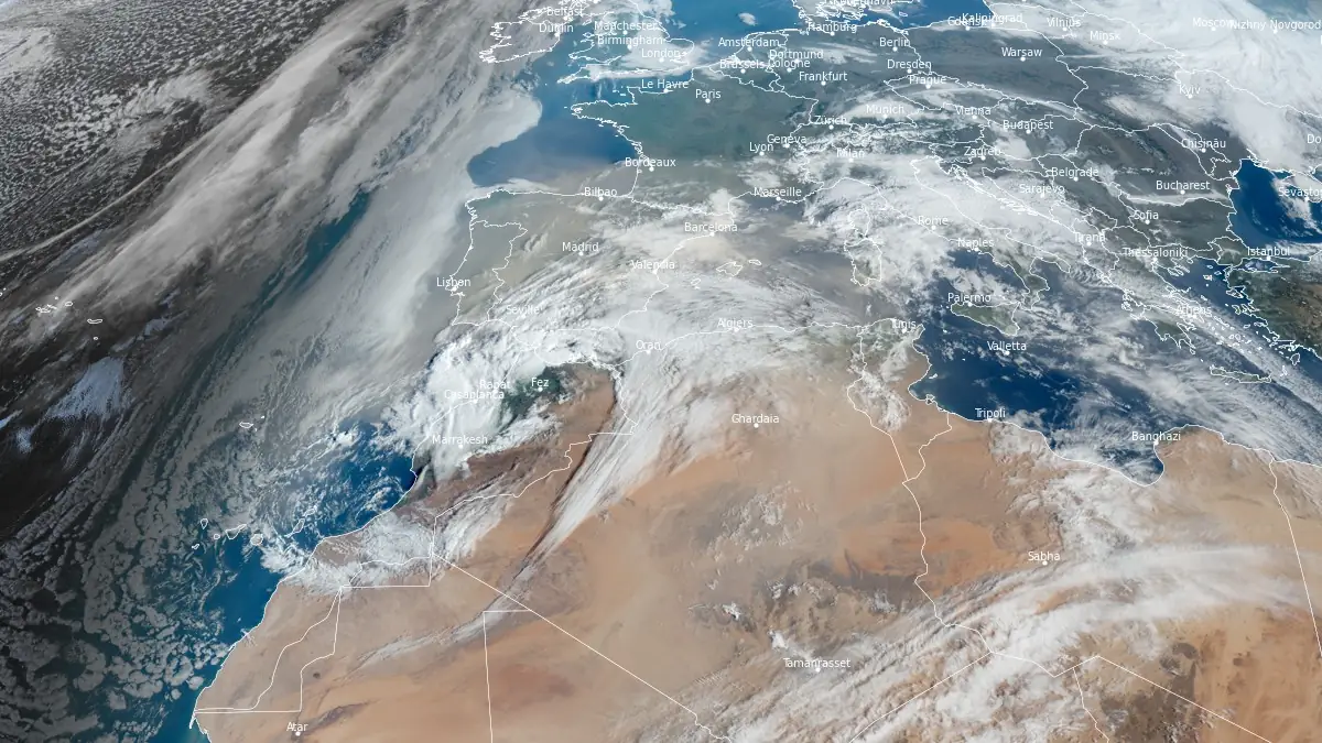
Satellite image showing Saharan dust over western Europe acquired at 08:10 UTC on March 4, 2026. Credit: EUMETSAT/Meteosat-12, The Watchers
A large plume of mineral dust originating over the central Sahara was advected north-northwest across the Mediterranean during the first week of March 2026.
At 00:00 UTC on March 4, the highest dust optical depth was centred over Algeria, Mali, and the western Sahara, extending through Tunisia toward southern Spain.
By 00:00 UTC on March 5, the core plume is forecast to expand across most of Spain and southern France, with moderate dust loading over the Balearic Islands, northern Italy, and the western Balkans. Model guidance for 00:00 UTC on March 6 shows the dust layer reaching the UK and Benelux region while weakening over the western Mediterranean, confirming a gradual dispersion phase.
According to the Copernicus Atmospheric Monitoring Service and the WMO Regional Specialized Meteorological Center Barcelona, the transport was driven by a persistent south-westerly flow ahead of an Atlantic trough. Ensemble forecasts from CAMS and BSC-DREAM predicted elevated aerosol optical depth values above 1.0 over parts of southern Spain and the western Mediterranean on March 4–5.
Ground observations reported visible haze and light dust deposition across Spain’s Mediterranean coast, southern France, and northern Italy. Air-quality indices in several cities reached the “unhealthy for sensitive groups” category, mainly due to increased PM10 and PM2.5 concentrations.
National agencies, including AEMET (Spain) and AtmoSud (France), advised individuals with respiratory conditions to limit outdoor activity until conditions improved.
Forecasts indicate the main dust layer will continue moving northeast through March 6 as frontal rainfall and stronger winds from the Atlantic promote washout and dilution. By March 7, most surface concentrations are expected to return to background values across western Europe, though residual aerosols may persist aloft over the Alps and central Europe.
Saharan dust intrusions are common in early spring when strengthening southerly flow interacts with surface heat over North Africa.
March marks the start of Europe’s seasonal dust-transport period, with events varying in duration and intensity depending on synoptic patterns. While dust-transport episodes contribute to nutrient deposition across the Mediterranean and Atlantic, they also temporarily degrade air quality and visibility.
References:
1 Dust Aerosol Optical Depth Forecast – CAMS – Accessed on March 4, 2026
2 Regional Dust Forecast – WMO RSMC Barcelona/AEMET – Accessed on March 4, 2026
I'm a dedicated researcher, journalist, and editor at The Watchers. With over 20 years of experience in the media industry, I specialize in hard science news, focusing on extreme weather, seismic and volcanic activity, space weather, and astronomy, including near-Earth objects and planetary defense strategies. You can reach me at teo /at/ watchers.news.
Commenting rules and guidelines
We value the thoughts and opinions of our readers and welcome healthy discussions on our website. In order to maintain a respectful and positive community, we ask that all commenters follow these rules.