
Dangerous storm surge forecast in the Bahamas as Hurricane Melissa moves across the islands toward Bermuda
Hurricane Melissa is forecast to produce a dangerous storm surge and life-threatening coastal flooding across the southeastern and central Bahamas on Wednesday, October 29, 2025. The system is expected to pass near or just west of Bermuda late Thursday and Thursday night, bringing hurricane-force winds and heavy rainfall to the island.
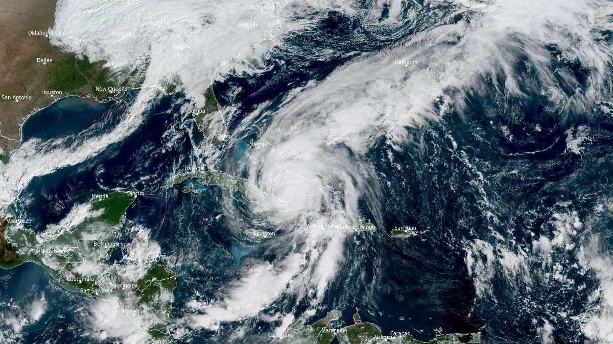
Satellite image of Hurricane Melissa at 14:40 UTC on October 29, 2025. Credit: NOAA/GOES-East, RAMMB/CIRA, The Watchers
NHC Key Messages:
- Eastern Cuba: Life-threatening storm surge, flash flooding and landslides, and damaging winds are ongoing through this afternoon. Remain in a safe shelter.
- Bahamas and the Turks and Caicos: Hurricane conditions, life-threatening storm surge, and heavy rainfall are expected across portions of the southeastern and central Bahamas today. Find a safe shelter and follow local official guidance. Tropical storm conditions, heavy rains, and significant storm surge are expected in the Turks and Caicos Islands today.
- Haiti and the Dominican Republic: Catastrophic flash flooding and landslides are expected across portions of Haiti and the Dominican Republic through today. In Haiti, extensive damage and isolation of communities is likely. Tropical storm conditions are expected through this afternoon. 4. Bermuda: Hurricane conditions and heavy rainfall are expected in Bermuda beginning late Thursday and continuing through Thursday night.
- Post-storm safety in impacted areas: Follow advice of local officials as you may need to remain sheltered after the storm due to downed power lines and flooded areas. Ensure generators are properly ventilated and placed outside at least 6 m (20 feet) away from dwellings and garages to avoid carbon monoxide poisoning. During clean up, be careful when using chainsaws and power tools. Drink plenty of water to avoid heat exhaustion.
At 11:00 EDT (15:00 UTC) on October 29, the center of Hurricane Melissa was located about 245 km (150 miles) south of the central Bahamas. The system is moving northeast at 22 km/h (14 mph) with maximum sustained winds of 155 km/h (100 mph) and higher gusts. The minimum central pressure is 974 mb.
According to the National Hurricane Center (NHC), a storm surge of 1.5–2.5 m (5–8 feet) above normally dry ground is possible across the southeastern and central Bahamas today. The surge will combine with large waves to produce life-threatening coastal inundation and hazardous surf conditions. Minor coastal flooding is possible in the Turks and Caicos Islands and along the north coast of eastern Cuba and Haiti.
A Hurricane Warning is in effect for the Cuban provinces of Granma, Santiago de Cuba, Guantánamo, Holguín, and Las Tunas, as well as for the southeastern and central Bahamas and Bermuda, while a Tropical Storm Warning is in effect for Haiti, the Cuban province of Camagüey, and the Turks and Caicos Islands.
Melissa is expected to produce 125–250 mm (5–10 inches) of rain across the southeastern Bahamas, leading to flash flooding in low-lying areas. Additional rainfall of 25–75 mm (1–3 inches) is expected in the Turks and Caicos Islands.
Over eastern Cuba, storm-total rainfall of 250–500 mm (10–20 inches) with local amounts up to 635 mm (25 inches) is expected, resulting in flash flooding and landslides. In southern Hispaniola, rainfall totals could reach up to 1 000 mm (40 inches) in isolated areas, causing catastrophic flooding and slope failures in mountainous terrain.

Melissa will continue moving northeast through the southwestern Atlantic, crossing the Bahamas today before accelerating toward Bermuda. The Meteorological Service of Bermuda has issued a hurricane warning, with tropical-storm-force winds expected to reach the island on Thursday morning, followed by hurricane-force winds late Thursday and Thursday night. Some slight strengthening is possible over the next 24 hours.
Swells generated by Melissa are affecting Hispaniola, Jamaica, Cuba, the Cayman Islands, the Bahamas, and the Turks and Caicos Islands, spreading toward Bermuda by Thursday. These swells will produce life-threatening surf and rip-current conditions along exposed coastlines.

Hurricane Melissa made landfall in Jamaica near New Hope on the island’s southwestern coast at about 13:00 EDT (17:00 UTC) on October 28, 2025. At the time of landfall, Melissa had sustained winds of about 295 km/h (185 mph), making it a Category 5 system on the Saffir–Simpson scale. The impact brought extreme winds and torrential rain across the island.
The second landfall occurred on the southern coast of eastern Cuba at approximately 03:10 EDT (07:10 UTC) on October 29. By that time, Melissa had weakened to a Category 3 hurricane with sustained winds near 195 km/h (120 mph). The storm then moved offshore into the southwestern Atlantic after crossing the eastern coastal zone.
In total, Melissa is blamed for the deaths of at least 32 people, most of them in Haiti, where severe flooding and landslides followed days of intense rainfall. At least 25 fatalities were confirmed there after rivers overflowed and swept through several communities.
Additional deaths were reported in Jamaica and the Dominican Republic, where widespread flooding and storm-related accidents occurred as the hurricane moved north toward Cuba.
References:
1 Hurricane Melissa Advisory Number 33 – NWS/NHC – October 29, 2025
2 Hurricane Melissa Discussion Number 33 – NWS/NHC – October 29, 2025
I'm a dedicated researcher, journalist, and editor at The Watchers. With over 20 years of experience in the media industry, I specialize in hard science news, focusing on extreme weather, seismic and volcanic activity, space weather, and astronomy, including near-Earth objects and planetary defense strategies. You can reach me at teo /at/ watchers.news.
Commenting rules and guidelines
We value the thoughts and opinions of our readers and welcome healthy discussions on our website. In order to maintain a respectful and positive community, we ask that all commenters follow these rules.