
Post-season NHC report finds Melissa tied for strongest Atlantic hurricane by maximum sustained wind
NOAA’s final Tropical Cyclone Report confirms that Hurricane Melissa reached Category 5 intensity with peak 1-minute sustained winds of 306 km/h (190 mph), tying for the highest maximum sustained wind speed on record in the Atlantic basin, and a minimum central pressure of 892 hPa. The hurricane made landfall near New Hope, Jamaica, at 17:25 UTC (13:25 LT) on October 28, 2025, resulting in 45 fatalities in Jamaica and 95 across the region, with economic losses in Jamaica estimated at USD 8.8 billion.

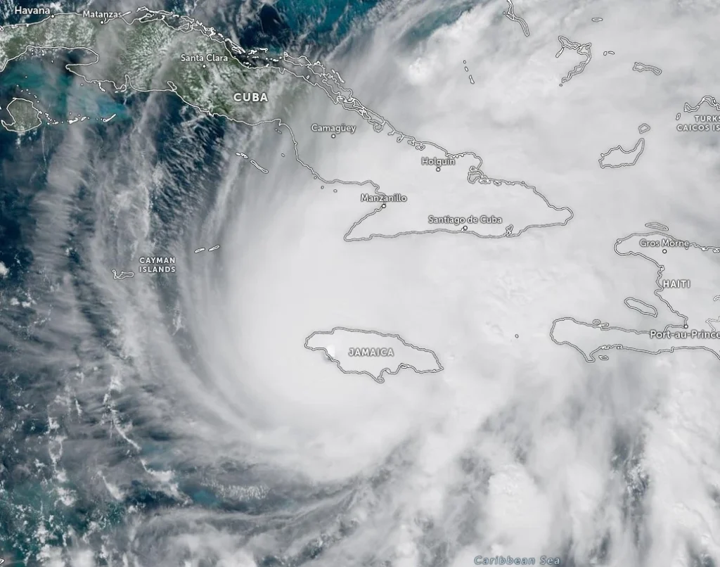
Hurricane Melissa near landfall in Jamaica at 14:00 UTC on October 28, 2026. Credit: NOAA/GOES-East, NHC
The National Hurricane Center has released its post-season report confirming that Hurricane Melissa was a Category 5 hurricane with peak sustained winds of 306 km/h (190 mph) and a central pressure of 892 hPa.
Melissa’s peak sustained winds of 306 km/h (190 mph) tie Hurricane Allen (1980) for the highest maximum sustained wind speed ever recorded in the Atlantic basin.
At landfall in Jamaica, sustained winds of 296 km/h (185 mph) made Melissa the strongest hurricane on record to strike Jamaica and tied the 1935 Labor Day Hurricane and Dorian (2019) for the strongest Atlantic landfall by wind speed.
Its minimum central pressure of 892 hPa is tied for the third lowest in Atlantic hurricane history, behind Wilma (882 hPa, 2005) and Gilbert (888 hPa, 1988).
In addition, a dropsonde measured an extreme instantaneous wind gust of 406 km/h (252 mph) within the eyewall — the strongest wind ever recorded by dropsonde in a tropical cyclone globally.
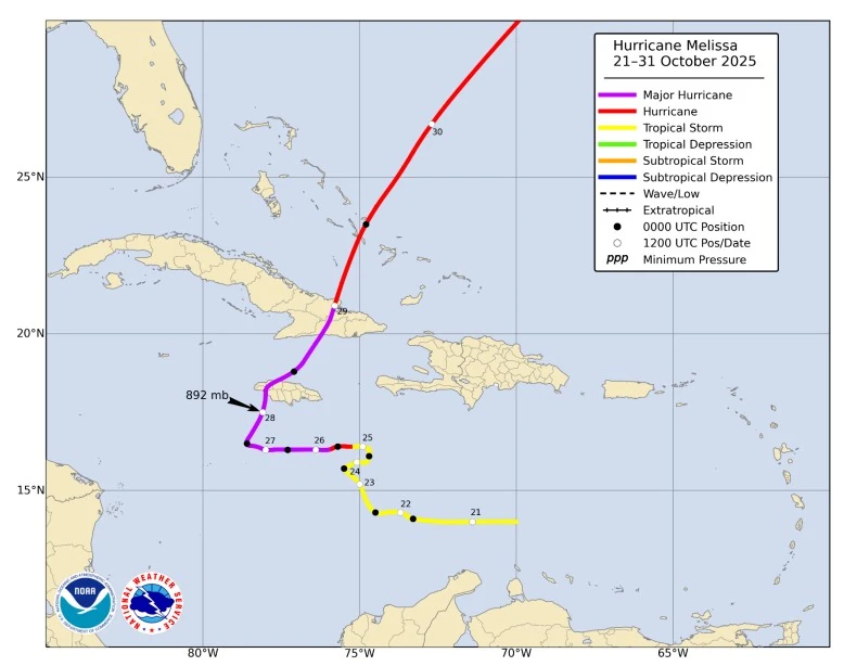
Melissa originated from a tropical wave that emerged from the west coast of Africa on October 13 and moved westward across the tropical Atlantic.
The system gradually organized over the central Caribbean Sea, and a closed low-level circulation formed at 06:00 UTC on October 21, marking the development of Tropical Storm Melissa about 510 km (317 miles) south of Port-au-Prince, Haiti, with maximum sustained winds of 74 km/h (46 mph).
Rapid intensification began on October 25 as Melissa moved over sea-surface temperatures of 30–31°C (86–88°F) with high oceanic heat content and decreasing vertical wind shear. The cyclone strengthened by 83 km/h (52 mph) in 24 hours and reached major hurricane status early on October 26. Aircraft reconnaissance documented a contracting radius of maximum winds, a well-defined 10 nautical mile (19 km / 12 miles) eye, and a sharp drop in central pressure.
The system made landfall near New Hope, Jamaica, around 17:25 UTC on October 28.
At landfall in Jamaica, Melissa produced sustained winds of about 296 km/h (185 mph) with gusts exceeding 320 km/h (200 mph) along the south and west coasts.
Storm surge heights ranged from 2.1 to 3.3 m (7 to 11 feet), while rainfall totals reached 817 mm (32.2 inches) at Knock Patrick.
The extreme winds, flooding, and landslides destroyed or damaged tens of thousands of homes and infrastructure, resulting in 45 deaths and damage valued at USD 8.8 billion, about 41% of the nation’s gross domestic product. A post-storm health crisis included a Leptospirosis outbreak linked to flooded areas.

Torrential rain caused severe flooding across Hispaniola, with Haiti recording 934 mm (36.8 inches) of rain at Camp Perrin, resulting in 43 fatalities and the displacement of tens of thousands of people as rivers overflowed and sanitation systems failed. In the Dominican Republic, rain peaked at 737 mm (29 inches) in Polo with four deaths reported.
Melissa made another landfall near Chivirico, Santiago de Cuba, as a Category 3 hurricane with winds of 185 km/h (115 mph) and a pressure of 954 hPa, damaging or destroying around 900 000 homes and causing one fatality.
After crossing Cuba, Melissa accelerated northeastward and made landfall on Long Island in the Bahamas at 22:15 UTC on October 29 with sustained winds of 150 km/h (93 mph). A second landfall followed on San Salvador Island at 02:00 UTC on October 30 at similar intensity. The storm then passed north of Bermuda while gradually weakening over cooler waters.
Two indirect fatalities occurred in Florida when an aircraft supporting relief operations crashed.
Melissa weakened as it moved over the cooler waters of the North Atlantic, became extratropical on October 31, opened into a trough on November 1, and merged with a larger mid-latitude system about two days later.
References:
1 Tropical Cyclone Report: Hurricane Melissa (AL132025) – National Hurricane Center – February 25, 2026

I’m a science journalist and researcher at The Watchers, contributing to the Epicenter edition, where I cover peer-reviewed scientific research and emerging discoveries across Earth and space sciences. With a background in astronomy and a passion for environmental science, I’ve worked in shark and coral conservation in Fiji, conducting reef and shark-behavior research, contributing to mangrove restoration, and earning PADI Open Water and Coral Reef Certifications. I bring a blend of scientific rigor and storytelling to illuminate the discoveries shaping our planet and beyond.
Commenting rules and guidelines
We value the thoughts and opinions of our readers and welcome healthy discussions on our website. In order to maintain a respectful and positive community, we ask that all commenters follow these rules.