
Catastrophic and life-threatening winds, flooding and storm surge forecast as Category 5 Hurricane Melissa nears Jamaica landfall
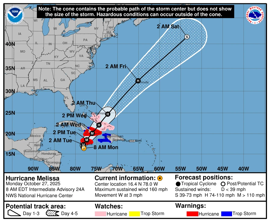
Hurricane Melissa reached Category 5 strength on Monday, October 27, 2025, becoming the third Category 5 hurricane of the 2025 Atlantic hurricane season. On the forecast track, the center of Melissa will be near or over Jamaica late tonight or early Tuesday, cross eastern Cuba Tuesday night or early Wednesday, and then move near or over the Bahamas and the Turks and Caicos on Wednesday. After that, the cyclone could reach the vicinity of Bermuda on Thursday night.
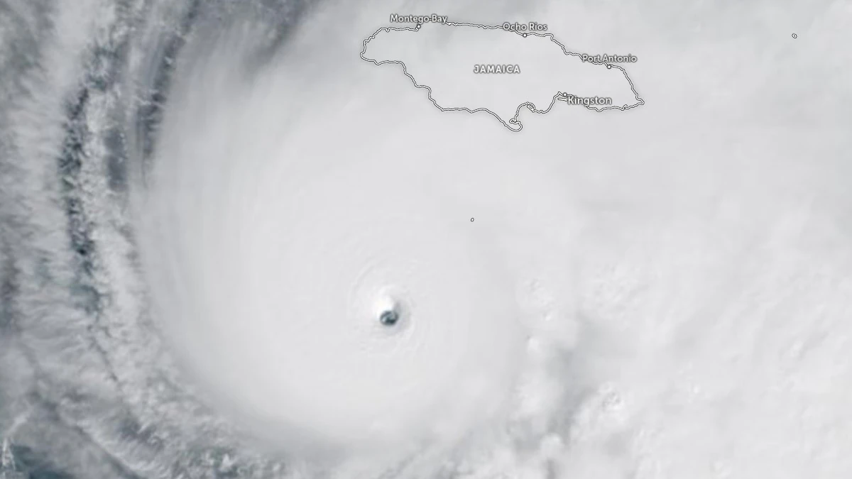
Satellite image of Category 5 Hurricane Melissa at 14:50 UTC on October 27, 2025. Credit: NOAA/GOES-East, Zoom Earth, The Watchers
- Jamaica: Do not venture out of your safe shelter. Catastrophic and life-threatening flash flooding and numerous landslides are likely today through Tuesday, October 28. Catastrophic winds in the eyewall have the potential to cause total structural failure, especially in higher elevation areas, tonight and early Tuesday. This will result in extensive infrastructural damage, long-lasting power and communication outages, and isolated communities. Life-threatening storm surge and damaging waves are expected along the southern coast through Tuesday.
- Haiti and the Dominican Republic: Catastrophic and life-threatening flash flooding and landslides are expected across southwestern Haiti and southern portions of the Dominican Republic through midweek. In Haiti, extensive infrastructural damage and isolation of communities is likely. Tropical storm conditions are expected late Tuesday and Wednesday.
- Eastern Cuba: Heavy rainfall, with life-threatening and potentially catastrophic flash flooding and landslides, is expected to begin today. Life-threatening storm surge and damaging winds are expected late Tuesday and Tuesday night. Preparations should be rushed to completion.
- Southeast Bahamas and the Turks and Caicos: Hurricane conditions, life-threatening storm surge, and heavy rainfall are possible on Wednesday. Residents should follow the advice given by local officials and be sure to have preparations complete by Tuesday night.
The National Hurricane Center designated Melissa as a Category 5 hurricane at 05:00 EDT (09:00 UTC) on October 27. At the time, the system was located about 210 km (130 miles) south-southwest of Kingston, Jamaica, and 505 km (315 miles) south-southwest of Guantánamo, Cuba.
Maximum sustained winds (averaged over one minute) had increased to 260 km/h (160 mph), with higher gusts. The estimated minimum central pressure dropped to 917 hPa as the storm moved westward at 5 km/h (3 mph).
The 2025 Atlantic hurricane season now ranks second for the number of Category 5 hurricanes, with three recorded. The only season with more is 2005, which produced four Category 5 hurricanes. Before 2025, the 2005 season was the only one on record with more than two Category 5 storms.

The system is forecast to take a slow turn toward the northwest and north is expected today and tonight, followed by a northeastward acceleration beginning on Tuesday and continuing through at least Thursday, October 29.
Hurricane Melissa is forecast to make landfall over Jamaica on Monday night or early Tuesday. Destructive winds, storm surge, and catastrophic flooding are expected to intensify across Jamaica through the day as the storm nears landfall.
Rainfall totals of 380 to 760 mm (15 to 30 inches) are forecast for Jamaica by Wednesday, October 29, with localized totals of up to 1 000 mm (40 inches).
Additional rainfall of 200 to 400 mm (8 to 16 inches) is forecast for southern Hispaniola through Wednesday, with localized totals of up to 1 000 mm (40 inches) possible.
Heavy rainfall of 250 to 380 mm (10 to 15 inches), with locally higher totals of up to 500 mm (20 inches), is forecast for eastern Cuba through Wednesday.
Heavy rainfall will lead to catastrophic flooding and life-threatening landslides in all affected regions as the storm moves closer to Jamaica.
The Jamaican government has ordered evacuations for parts of the capital, Kingston, and the entire island has been declared “threatened.” Prime Minister Andrew Holness has ordered the immediate evacuation of several vulnerable communities across the island.
Jamaica’s Minister of Local Government, Desmond McKenzie, told local media that all 881 shelters on the island are open.
Hurricane Melissa has already killed four people across Hispaniola and could be the strongest hurricane to ever hit Jamaica, according to the BBC.
At least three people are known to have died, and hundreds of homes have been flooded in Haiti as Melissa brought torrential rainfall to Hispaniola. One person was reported dead in the Dominican Republic.
Local media identified the victim as a 79-year-old man who was swept away by floodwaters in the capital, Santo Domingo.
A 13-year-old boy has also been reported missing after being dragged away by strong currents while swimming in the sea. Multiple rescues were conducted after people became trapped in their cars due to rising floodwaters.
A Hurricane Warning is in effect for Jamaica and for the Cuban provinces of Granma, Santiago de Cuba, Guantánamo, and Holguín.
A Hurricane Watch is in effect for the southeastern and central Bahamas, along with the Turks and Caicos Islands. Meanwhile, a Tropical Storm Warning is in effect for Haiti and the Cuban province of Las Tunas.
A life-threatening storm surge is likely along the south coast of Jamaica tonight and on Tuesday. Peak storm surge heights could reach 2.7 to 4 m (9 to 13 feet) above ground level, near and to the east of where the center of Melissa makes landfall. This surge will be accompanied by large and destructive waves.
There is potential for significant storm surge along the southeast coast of Cuba late Tuesday or Wednesday. Peak storm surge heights could reach 1.8 to 2.7 m (6 to 9 feet) above normal tide levels, near and to the east of where the center of Melissa makes landfall.
This storm surge will also be accompanied by large and destructive waves. Meanwhile, storm surge is possible in the southeastern Bahamas and the Turks and Caicos Islands on Wednesday.

I am an Assistant Editor and Severe Weather & Science Journalist at The Watchers, specializing in real-time severe weather coverage, geophysical event reporting, and research-driven scientific analysis. You can reach me at rishav(at)watchers(.)news.
Commenting rules and guidelines
We value the thoughts and opinions of our readers and welcome healthy discussions on our website. In order to maintain a respectful and positive community, we ask that all commenters follow these rules.